Click to visit the main New York Public Library Homepage
The New York Public Library
Digital Collections
About Digital Collections
Browse
Search only public domain materials
Items
Collections
Divisions
Home
Search
Browse
About
Search only public domain materials
Items
Collections
Divisions
Digital Collections
Using Images
Using Data
Collections
Charting America: Maps from the Lawrence H. Slaughter Collection and Others
Charting America: Maps from the Lawrence H. Slaughter Collection and Others
Navigation
Filters
Charting America: Maps from the Lawrence H. Slaughter Collection and Others
Previous
The south part of Virginia, now the north part of Carolina
0
Atlases, gazetteers, guidebooks and other books
377
Maps of the World
16
Maps of the Oceans
24
Maps of North and South America
23
Maps of North America.
551
Maps of New York City and State
1340
Lawrence H. Slaughter Collection of English maps, charts, globes, books and atlases
1020
John H. Levine Collection
60
More
Show filters
Hide filters
Show Only Public Domain
topic
Administrative and political divisions
282
Railroads
264
Real property
249
Landowners
181
City planning
102
More
Less
name
New York (N.Y.). Common Council
85
Mitchell, S. Augustus (Samuel Augustus), 1792-1868
49
Wells, Edward, 1667-1727
41
Moll, Herman, -1732
40
Dripps, M. (Matthew)
39
More
Less
collection
Maps of New York City and State
1370
Lawrence H. Slaughter Collection of English maps, charts, globes, books and atlases
221
Atlases, gazetteers, guidebooks and other books
73
John H. Levine Collection
11
Maps of the World
5
More
Less
place
New York (State)
922
New York (N.Y.)
454
New York
358
Manhattan (New York, N.Y.)
244
Brooklyn (New York, N.Y.)
205
More
Less
genre
Maps
1673
Cadastral maps
151
Manuscript maps
52
Topographic maps
24
Road maps
23
More
Less
publisher
publisher not identified
72
S. A. Mitchell, jr
42
Printed at the Theater,
38
G.W. & C.B. Colton & Co
33
... Sold ... by Tho. Bowles, print and map-seller in St. Paul's-Churchyard
28
More
Less
division
Map Division
1684
Manuscripts and Archives Division
2
type
cartographic
1666
text
19
still image
13
Date Range
to
1,686 results found for:
Islip (N.Y. : Town) -- Maps?tab=filter
Sort by:
Relevance
Title
Date created
Date digitized
Sequence
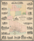
Map
of the
town
of Waterloo, Seneca County,
N
note:
Town
map
shows
m
Map
of the
town
of Morrisania, Westchester Co.
N
note:
Cadastral
map
showing wards, buildings
m
Map
of the
town
note:
Cadastral
map
.
… County,
N
.
Y
. …
abstract:
Cadastral
map
bound
Map
of the
town
note:
… catalog of the
Map
m
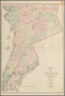
Map
of Allegany Co.,
N
.
Y
.
note:
LC copy hand colored to emphasize
town
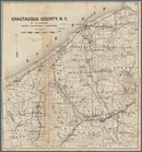
Map
of Chautauqua County,
N
.
Y
note:
… County,
N.Y
., for 1873-4, Syracuse,
N.Y
., 1873.
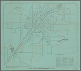
Map
of Saratoga Springs,
N
.
Y
.
note:
Mapping
the Nation (NEH grant, 2015-2018)…
m
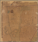
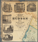
Map
of the City of Hudson,
N
.
Y
.
note:
Mapping
the Nation (NEH grant, 2015-2018)…
Map
of Westchester County,
N
.
Y
.
note:
Shows cities and
towns
, post offices
m
Map
of Kings County
N
.
Y
.
abstract:
… of Brooklyn and 6 rural
towns
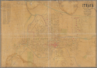
Map
of City of Ithaca,
N
.
Y
.
note:
Mapping
the Nation (NEH grant, 2015-2018)…
Town
of Greenburgh, Westchester Co.,
N
.
Y
.
note:
….,
N.Y
. -- Harts Corners
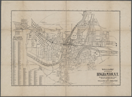
Williams'
map
of the City of Binghamton,
N
.
Y
.
note:
…., Bing.,
N.Y
."…
Map
of Richland, Oswego Co.
N
.
Y
.
note:
… (
N.Y
.).
m
Hagstrom's
map
of Queens
N
.
Y
. City …
note:
NYPL
Map
Div. copy has accession no
Geologic
map
of Orange County,
N
.
Y
.
note:
Mapping
the Nation (NEH grant, 2015-2018)…
m
Map
of Geneva, Ontario Co.,
N
.
Y
.
note:
Mapping
the Nation (NEH grant, 2015-2018)…
Road
map
of Westchester Co.,
N
.
Y
.
note:
Stevens & Morris, eng.,
N.Y
.
Geologic
map
of Rye,
N
.
Y
. and vicinity
note:
Mapping
the Nation (NEH grant, 2015-2018)…
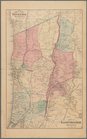
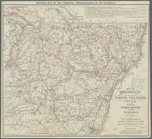
Topographical
map
of Seneca County,
N
.
Y
.
note:
Shows cities and
towns
, military survey
….,
N
.
Y
.
note:
Shows cities and
towns
, roads, railroads
Town
& village of Ovid, Seneca Co.,
N
.
Y
.
note:
Wall
map
showing city wards
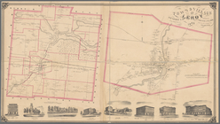
Town
& Village of Leroy, Genesee Co.,
N
.
Y
.
note:
Town
map
shows
….,
N
.
Y
. and portions
note:
Mapping
the Nation (NEH grant, 2015-2018)…
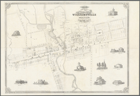
Map
of the village of Williamsville in Erie County,
N
note:
Cadastral
map
showing building
m
Map
of Oswego, Oswego Co.,
N
.
Y
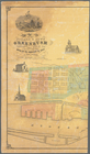
., 1851
note:
Map
within decorative border.
m
New
map
of St. Lawrence County,
N
.
Y
note:
Mapping
the Nation (NEH grant, 2015-2018)…
m
Map
of the City of Utica, Oneida Co.,
N
.
Y
.
note:
Map
shows city wards, streets names
Map
of Buffalo Harbor,
N
.
Y
., August 1854
note:
Mapping
the Nation (NEH grant, 2015-2018)…
… County,
N
.
Y
.
note:
Map
shows townships, block and lot numbers
… of Dunkirk,
N
.
Y
.
note:
Mapping
the Nation (NEH grant, 2015-2018)…
… of Erie,
N
.
Y
note:
… with
Map
of the
town
… County,
N
.
Y
.
note:
N
.F. Barrett, landscape engineer ; L. E
Towns
of West Farms and Morrisania, Weschester Co.,
N
note:
Shows cities and
towns
, streets
Map
of the
town
of Niagara
note:
… of Niagara Falls (
N.Y
.).
Map
of the
town
of Morrisania
note:
Survey
map
showing block dimensions, street
Map
of part
note:
… catalog of the
Map
… County
N
.
Y
.
note:
Shows roads, rivers, and buildings in the
town
m
… County,
N
.
Y
.
note:
Cadastral
map
showing property owners
m
….,
N
.
Y
.
note:
Cadastral
map
also showing wards, streets
Map
of Long Island City, Queens Co.
N
.
Y
.
collection:
Map
of Long Island City, Queens Co.
N.Y
.
Map
of lands in the
town
of Yonkers
note:
Mapping
the Nation (NEH grant, 2015-2018)…
Map
of part of
Town
of Fishkill
note:
Mapping
the Nation (NEH grant, 2015-2018)…
m
Map
of the village &
town
of Greenbush
note:
Cadastral
map
showing streets, lots
m
…, Long Island
N
.
Y
.
note:
Mapping
the Nation (NEH grant, 2015-2018)…
…, Chatauque Co.
N
.
Y
.
note:
Includes text, note, and inset
map
of: "Part
… of Niagara County,
N
.
Y
.
note:
… Washington St., Buffalo,
N.Y
."…
m
…, Long Island,
N
.
Y
.
note:
Cadastral
map
showing property owners
…, Long Island,
N
.
Y
note:
Cadastral
map
showing property owners
1
2
3
4
5
6
7
Previous
Next
1
2
3
4
5
6
7
Previous
Next