Click to visit the main New York Public Library Homepage
The New York Public Library
Digital Collections
About Digital Collections
Browse
Search only public domain materials
Items
Collections
Divisions
Home
Search
Browse
About
Search only public domain materials
Items
Collections
Divisions
Digital Collections
Using Images
Using Data
Collections
Charting America: Maps from the Lawrence H. Slaughter Collection and Others
Charting America: Maps from the Lawrence H. Slaughter Collection and Others
Navigation
Filters
Charting America: Maps from the Lawrence H. Slaughter Collection and Others
Previous
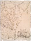
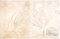
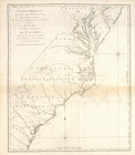
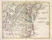
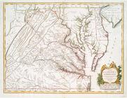
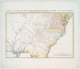
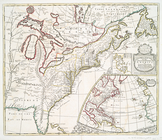
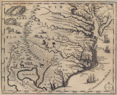
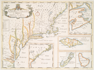
The south part of Virginia, now the north part of Carolina
0
Atlases, gazetteers, guidebooks and other books
377
Maps of the World
16
Maps of the Oceans
24
Maps of North and South America
23
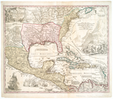
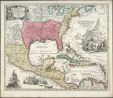
Maps of North America.
551
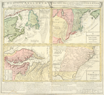
Maps of New York City and State
1340
Lawrence H. Slaughter Collection of English maps, charts, globes, books and atlases
1020
John H. Levine Collection
60
More
Show filters
Hide filters
Show Only Public Domain
topic
Atlases, British
3
Coasts
3
Colonies
3
Geography
3
Nautical charts
3
More
Less
name
Homann Erben (Firm)
6
Homann, Johann Baptist, 1663-1724
5
Fry, Joshua, approximately 1700-1754
4
Jefferson, Peter, 1708-1757
4
Jefferys, Thomas, -1771
4
More
Less
collection
Lawrence H. Slaughter Collection of English maps, charts, globes, books and atlases
49
John H. Levine Collection
8
Atlases, gazetteers, guidebooks and other books
1
place
North America
16
North Carolina
15
Virginia
13
South Carolina
9
Virginia -- Maps -- Early works to 1800
9
More
Less
genre
Maps
58
publisher
Presso Antonio Zatta
4
Homann Erben
3
s.n
3
Chez Cóvens & Mortier
2
Edward Wells
2
More
Less
division
Map Division
58
type
cartographic
58
text
1
Date Range
to
58 results found for:
North Carolina?tab=filter
Sort by:
Relevance
Title
Date created
Date digitized
Sequence
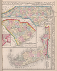
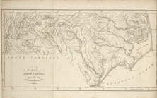
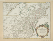
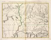
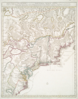
County map of
North
Carolina
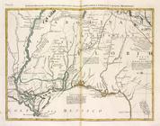
, Map of South
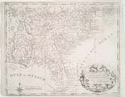
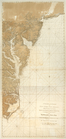
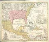
United States of Nth. America…
A chart of Delaware Bay and R…
collection:
… part of the
North
… and
North
Carolina
… of Virginia,
North
Carolina
, South
Carolina
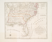
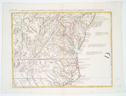
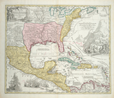
A map of
North
Carolina
, from the best
… of Virginia,
North
Carolina
, South
Carolina
note:
Kendall, H.P. Early maps of
Carolina
83.
… and
North
Carolina
Virginia
… of
North
America, comprehending the two
Carolinas
note:
… for marches in South
Carolina
,
North
Carolina
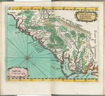
Carte réduite du Sud des État…
abstract:
…, Maryland, Virginia,
North
Carolina
, South
Carolina
Partie de l'Amerique septentr…
note:
Variant of LC Maps of
North
America, 1750-1789
…, Maryland, Virginia,
North
Carolina
, & c.
note:
LC Maps of
North
America, 1750-1789, 766
…, Maryland, Virginia,
North
Carolina
, & c.
…
Carolina
Settentrionale.
…
Carolina
Settentrionale.
… Occidentale della
Carolina
… Georgia, e
Carolina
Merid
collection:
… Georgia, e
Carolina
… Georgia, e
Carolina
m
… and
North
Carolina
… and
North
Carolina
Part of
North
America
abstract:
… to
Carolina
.
…,
Carolinae
, Virginiae
…,
Carolinae
, Virginiae et
note:
LC Maps of
North
America, 1750-1789, 82
Dominia Anglorum in America S…
note:
… Maryland -- D.
Carolina
Carte de la Louisiane, Maryla…
note:
LC Maps of
North
America, 1750-1789, 1386
Carte de la Louisiane, Maryla…
note:
LC Maps of
North
America, 1750-1789, 1386
… and
North
Carolina
note:
LC Maps of
North
America, 1750-1789, 1428
Partie de l'Amérique septentr…
note:
LC Maps of
North
America, 1750-1789, 718
A New map of Virginia.
note:
… and
North
Carolina
.
m
… continent of
North
America
note:
… part of
North
America
A chart of the Atlantick Ocea…
note:
… of
North
America from Labrador to South
Carolina
.
A new map of the English empi…
A new map of the English empi…
…,
Carolinae
, Virginiae
…,
Carolinae
, Virginiae
…,
Carolinae
, Virginiae
note:
LC Maps of
North
America, 1750-1789, 82
…,
North
Carolina
, and South
Carolina
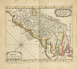
Carolina
newly discribed
abstract:
Covers as far
north
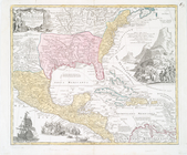
A new map of the most conside…
note:
… --
Carolina
.
A new map of the most conside…
note:
… --
Carolina
.
m
Nova tabula geographica compl…
A new map of the most conside…
note:
… --
Carolina
.
Nova tabula geographica compl…
Partie orientale du Canada ou…
note:
Shows eastern
North
Carolina
newly discribed
note:
Covers as far
north
as southern Virginia
…, Maryland &
Carolina
, from C
m
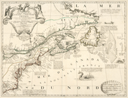
North
America divided into its
note:
…, and Ireland, this map of
North
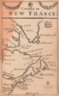
Canada, or, New France
note:
…, and the Atlantic coast of
North
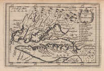
Virginia and Maryland.
note:
Oriented with
north
to the right.
… the islands in the
North
Sea
note:
…,
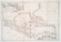
Carolina
and Florida.