Click to visit the main New York Public Library Homepage
The New York Public Library
Digital Collections
About Digital Collections
Browse
Search only public domain materials
Items
Collections
Divisions
Home
Search
Browse
About
Search only public domain materials
Items
Collections
Divisions
Digital Collections
Using Images
Using Data
Collections
Charting America: Maps from the Lawrence H. Slaughter Collection and Others
Charting America: Maps from the Lawrence H. Slaughter Collection and Others
Navigation
Filters
Charting America: Maps from the Lawrence H. Slaughter Collection and Others
Previous
The south part of Virginia, now the north part of Carolina
0
Atlases, gazetteers, guidebooks and other books
377
Maps of the World
16
Maps of the Oceans
24
Maps of North and South America
23
Maps of North America.
551
Maps of New York City and State
1340
Lawrence H. Slaughter Collection of English maps, charts, globes, books and atlases
1020
John H. Levine Collection
60
More
Show filters
Hide filters
Show Only Public Domain
topic
Administrative and political divisions
11
Real property
9
Railroads
8
History
6
Nautical charts
5
More
Less
name
Burr, David H., 1803-1875
9
S. Stiles & Co
7
Hooker, William
5
Sayer, Robert, 1725-1794
5
Disturnell, John, 1801-1877
4
More
Less
collection
Maps of New York City and State
50
Lawrence H. Slaughter Collection of English maps, charts, globes, books and atlases
22
Atlases, gazetteers, guidebooks and other books
7
John H. Levine Collection
4
Maps of North and South America
2
place
New York (State)
28
New York (N.Y.)
19
Manhattan (New York, N.Y.) -- Maps
14
New York (N.Y.) -- Maps
13
New York
10
More
Less
genre
Maps
85
Cadastral maps
5
Manuscript maps
3
Early works to 1800
1
Facsimiles
1
More
Less
publisher
s.n
6
Printed for Robert Sayer, No. 53, Fleet-Street
3
S. A. Mitchell, jr
3
S.R. Stoddard
3
W. Hooker
3
More
Less
division
x
Map Division
type
cartographic
84
text
3
still image
1
Date Range
to
85 results found for:
x
West (U.S.)?tab=filter
Filtering on:
x
Division
: Map Division
Sort by:
Relevance
Title
Date created
Date digitized
Sequence
1863,
West
Point
note:
…"History of
West
Point" -- top center
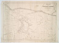
Route of the Albany &
West
Stockbridge Rail
note:
… of Albany, N.Y. and
West
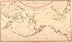
A New generall chart for the
West
note:
… and
S
100.
West
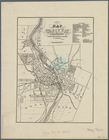
Point, New York
A chart of the
West
Indies, from the latest
A Generall chart for the
West
Indies : according
note:
… and
S
140.
Plan of
West
Point
note:
… to the
U.S
. Military Academy
A new generall chart for the
West
note:
… and
S
14º, adjacent
West
Point
note:
…"Lithograph'd by T.B. Brown,
U.S
. Army."…
A new generall chart for the
West
note:
… and
S
100.
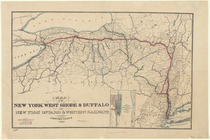
Map of the New York
West
Shore & Buffalo
note:
compiled by F.
S
. Cook, 20 Nassau St
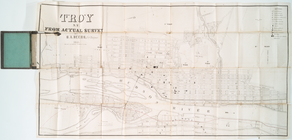
Troy, N.Y., from actual survey
note:
Covers also parts of Green Island and
West
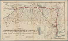
Map of the New York
West
Shore & Buffalo
note:
compiled by F.
S
. Cook, Mills building 35
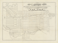
Map of the Ebenezer lands in …
note:
… ... in the town of
West
Seneca
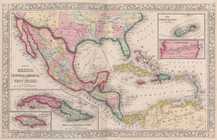
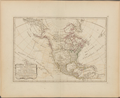
America with those known part…
note:
[Heading
West
; 5]
Map of the Adirondack wildern…
note:
… on the north,
west
, and south
A topographical map of Lewis …
note:
… of Lowville --
West
Map of the Adirondack wildern…
note:
… on the north,
west
, and south
Map of the Adirondack wildern…
note:
… on the north,
west
, and south
… with the
West
India Islands
note:
…"N.B. The letters E, F,
S
, D, Da, annexed
… with the
West
India Islands
note:
…"N.B. The letters E, F,
S
, D, Da, annexed
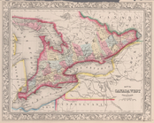
Map of Canada
West
in counties.
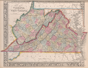
County map of Virginia and
West
Virginia.
A new and accurate map of the…
note:
…"Longitude
west
A new generall chart for the
West
note:
… and
S
14º, adjacent
Castrum Mauritij Ad Ripam Fluminis
S
m
Hammond's complete map of New…
New-York.
note:
…. on the
west
and south of 31st
Block distribution of childre…
abstract:
…,
West
Broadway, Walker
Map of the city of Rochester:…
note:
S
. Cornell, surveyor.
Map of Bellaire Estates : own…
note:
Includes vignette of P.
S
. 34.
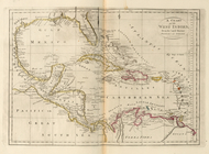
A chart of North and South Am…
note:
…, and the
West
Indies -- Chart
Chart of the N.W. coast of Am…
note:
[Heading
West
; 19]
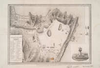
Sketch of
West
Pier, Oswego Harbor, September
note:
M. P. Hatch,
U.S
. agent.
…, and the
West
Indies ; Map
Country-seat of Danl. P. Barn…
note:
Geo. W. Van Siclen, B.
S
.
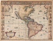
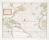
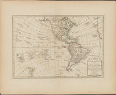
America North and South and the
West
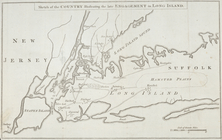
Sketch of the country illustr…
abstract:
…., on the
west
and south
m
Map of property belonging to Milton
S
note:
Shows several lots on the
west
side of East 10th
Hammond's complete map of New…
… and
west
shores of the East
note:
… of Engineers,
U.S
A Map of Carolana and of the …
note:
Covers
U.S
. as far
west
as the Rocky
Vereinigte Staaten in Nord Am…
note:
Covers
U.S
. as far
west
as the Great
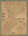
Map of
West
Chester County, New York
North America, with the
West
Indies, wherein
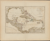
A compleat map of the
West
Indies, containing
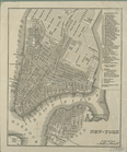
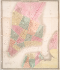
City of New-York
note:
Covers Manhattan to 26th St. on the
west
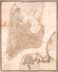
Map of the city of New-York
note:
Covers Manhattan up to 33rd St. on the
west
City of New-York
note:
Covers Manhattan up to 26th St. on the
west
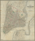
Map of the city of New-York
note:
Covers Manhattan up to 22nd St. on the
west