Click to visit the main New York Public Library Homepage
The New York Public Library
Digital Collections
About Digital Collections
Browse
Search only public domain materials
Items
Collections
Divisions
Home
Search
Browse
About
Search only public domain materials
Items
Collections
Divisions
Digital Collections
Using Images
Using Data
Collections
Charting America: Maps from the Lawrence H. Slaughter Collection and Others
Charting America: Maps from the Lawrence H. Slaughter Collection and Others
Navigation
Filters
Charting America: Maps from the Lawrence H. Slaughter Collection and Others
Previous
The south part of Virginia, now the north part of Carolina
0
Atlases, gazetteers, guidebooks and other books
377
Maps of the World
16
Maps of the Oceans
24
Maps of North and South America
23
Maps of North America.
551
Maps of New York City and State
1340
Lawrence H. Slaughter Collection of English maps, charts, globes, books and atlases
1020
John H. Levine Collection
60
More
Show filters
Hide filters
Show Only Public Domain
topic
Roads
22
Railroads
12
Administrative and political divisions
9
Local transit
4
Railroads, Elevated
4
More
Less
name
G.W. & C.B. Colton & Co
8
Rand McNally and Company
5
Buell & Wilgus
1
C.S. Hammond & Company
1
Colles, Christopher, 1738-1816
1
More
Less
collection
Maps of New York City and State
28
place
New York (State)
27
New York Metropolitan Area
10
New York
7
Long Island (N.Y.)
4
New Jersey
4
More
Less
genre
x
Road maps
Maps
28
Mass transit
3
Wall maps
2
Facsimiles
1
More
Less
publisher
G.W. & C.B. Colton & Co
9
The Company
4
Buell & Wilgus
1
C.S. Hammond & Co
1
Colton, Ohman & Co., Geographical Publishers
1
More
Less
division
Map Division
28
type
cartographic
28
Date Range
to
28 results found for:
x
New York (N.Y.)?tab=filter
Filtering on:
x
Genre
: Road maps
Sort by:
Relevance
Title
Date created
Date digitized
Sequence
Distance map of the state of
New
York
use:
… partner (e.g.,
New
York
… of
New
York
, pursuant
use:
… partner (e.g.,
New
York
Van Loan's road map of the Ca…
use:
… partner (e.g.,
New
York
New
York
to
New
Rochelle
use:
… partner (e.g.,
New
York
m
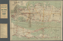
Colton's road map of Long Isl…
use:
… partner (e.g.,
New
York
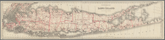
Map of Long Island
use:
… partner (e.g.,
New
York
Colton's road map of Long Isl…
use:
… partner (e.g.,
New
York
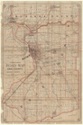
… of Niagara County,
N
.
Y
.
use:
… partner (e.g.,
New
York
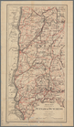
… & Dutchess,
New
York
use:
… partner (e.g.,
New
York
… & Dutchess,
New
York
use:
… partner (e.g.,
New
York
… of
New
York
use:
… partner (e.g.,
New
York
… and Rockland, state of
New
York
use:
… partner (e.g.,
New
York
Road map of Westchester Co.,
N
.
Y
.
use:
… partner (e.g.,
New
York
Colton's map of the county of…
use:
… partner (e.g.,
New
York
Colton's map of the county of…
use:
… partner (e.g.,
New
York
… of
New
York
use:
… partner (e.g.,
New
York
Driving road chart of Westche…
use:
… partner (e.g.,
New
York
Rand McNally & Co.'s
new
handy map
use:
… partner (e.g.,
New
York
m
Hammond's complete map of Bro…
use:
… partner (e.g.,
New
York
m
Cyclists' road map of
New
York
use:
… partner (e.g.,
New
York
m
Map of
New
York
City …
use:
… partner (e.g.,
New
York
m
The five boroughs of the city of
New
York
use:
… partner (e.g.,
New
York
m
Hagstrom's map of Queens
N
.
Y
. City …
use:
… partner (e.g.,
New
York
… the city of
New
York
use:
… partner (e.g.,
New
York
m
… to golf links,
New
York
use:
… partner (e.g.,
New
York
Rand Mcnally official detaile…
use:
… partner (e.g.,
New
York
… map
New
York
City
use:
… partner (e.g.,
New
York
New
York
and vicinity roads and rail
use:
… partner (e.g.,
New
York
End of results
|
Top