Click to visit the main New York Public Library Homepage
The New York Public Library
Digital Collections
About Digital Collections
Browse
Search only public domain materials
Items
Collections
Divisions
Home
Search
Browse
About
Search only public domain materials
Items
Collections
Divisions
Digital Collections
Using Images
Using Data
Collections
Charting America: Maps from the Lawrence H. Slaughter Collection and Others
Charting America: Maps from the Lawrence H. Slaughter Collection and Others
Navigation
Filters
Charting America: Maps from the Lawrence H. Slaughter Collection and Others
Previous
The south part of Virginia, now the north part of Carolina
0
Atlases, gazetteers, guidebooks and other books
377
Maps of the World
16
Maps of the Oceans
24
Maps of North and South America
23
Maps of North America.
551
Maps of New York City and State
1340
Lawrence H. Slaughter Collection of English maps, charts, globes, books and atlases
1020
John H. Levine Collection
60
More
Show filters
Hide filters
Show Only Public Domain
topic
Railroads
8
Local transit
6
Piers
6
Buildings
3
City planning
3
More
Less
name
New York Central and Hudson River Railroad Company
3
Taunton, S. D. L
3
United States. War Department
3
Andrews, Peter, fl. 1765-1782
2
Dripps, M. (Matthew)
2
More
Less
collection
Maps of New York City and State
22
Lawrence H. Slaughter Collection of English maps, charts, globes, books and atlases
2
place
x
Manhattan (New York, N.Y.)
New York (N.Y.)
23
New York (State)
20
New York
13
Bronx (New York, N.Y.)
6
More
Less
genre
Maps
24
Manuscript maps
3
Tourist maps
3
Cadastral maps
2
publisher
producer not identified
3
G.W. & C.B. Colton & Co
2
J.N. Matthews Co
2
S.D.L. Taunton, 88 Warren St
2
Sold by A. Dury, Dukes Court, St. Martins Lane
2
More
Less
division
Map Division
24
type
cartographic
24
Date Range
to
24 results found for:
x
Hudson River (N.Y. and N.J.)?tab=filter
Filtering on:
x
Place
: Manhattan (New York, N.Y.)
Sort by:
Relevance
Title
Date created
Date digitized
Sequence
A plan of the city of New-Yor…
note:
Stokes, I.
N
. P. Iconography of Manhattan
A plan of the city of New-Yor…
note:
Stokes, I.
N
. P. Iconography of Manhattan
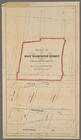
Map (A) of West Washington Ma…
note:
…., and the pier line at
Hudson
River
.
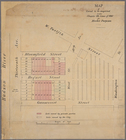
Map drawn for "The Morningsid…
note:
… by 110th Street,
Hudson
River
, 130th Street
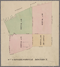
New York City, 8th Congressio…
note:
…, Houston Street and
Hudson
River
.
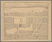
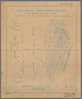
Map of land to be acquired un…
note:
… and the
Hudson
River
, Manhattan, New York (
N.Y
.) Shows
m
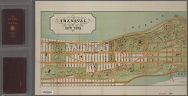
The Transval of New York
note:
… the Harlem and
Hudson
rivers
m
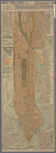
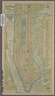
Taunton new guide map and dir…
note:
… of the
Hudson
River
from New
m
Taunton new guide map and dir…
note:
…ʹ22ʺ/
N
40°46ʹ40ʺ--
N
… Central &
Hudson
River
R
note:
…ʹ39ʺ/
N
40°51ʹ28ʺ--
N
… of the
Hudson
River
extending
note:
…
River
and the
Hudson
River
in Manhattan, New
Location of North
River
Bridge
note:
Shows banks of
Hudson
River
on Manhattan
m
… to the
Hudson
River
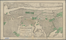
The heart of greater New York…
note:
… Park, New York (
N.Y
.); also the
Hudson
River
m
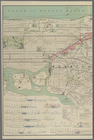
Center of New York, first cit…
m
… Street, and
Hudson
River
m
… Avenue to
Hudson
River
collection:
…, and Lenox Avenue to
Hudson
River
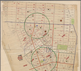
Block distribution of childre…
abstract:
… Street and
Hudson
River
.
m
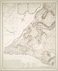
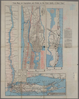
Topographical map of New York…
note:
… cities along the
Hudson
River
.
m
Taunton new guide map and dir…
note:
… of the
Hudson
River
from New
… to the
Hudson
River
note:
… 73°58ʹ42ʺ--W 73°54ʹ35ʺ/
N
40°52ʹ47ʺ--
N
40°46ʹ53ʺ)…
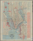
New-York City, County, and vi…
note:
…, and neighboring parts of
Hudson
County,
N.J
., Bronx
Center of New York, first cit…
note:
… York Central &
Hudson
River
R.R.
Tracts and farms with street …
note:
… bound by
Hudson
River
End of results
|
Top