Click to visit the main New York Public Library Homepage
The New York Public Library
Digital Collections
About Digital Collections
Browse
Search only public domain materials
Items
Collections
Divisions
Home
Search
Browse
About
Search only public domain materials
Items
Collections
Divisions
Digital Collections
Using Images
Using Data
Collections
Charting America: Maps from the Lawrence H. Slaughter Collection and Others
Charting America: Maps from the Lawrence H. Slaughter Collection and Others
Navigation
Filters
Charting America: Maps from the Lawrence H. Slaughter Collection and Others
Previous
The south part of Virginia, now the north part of Carolina
0
Atlases, gazetteers, guidebooks and other books
377
Maps of the World
16
Maps of the Oceans
24
Maps of North and South America
23
Maps of North America.
551
Maps of New York City and State
1340
Lawrence H. Slaughter Collection of English maps, charts, globes, books and atlases
1020
John H. Levine Collection
60
More
Show filters
Hide filters
Show Only Public Domain
topic
Atlases, British
2
Middle Atlantic States
1
name
Morden, Robert, approximately 1650-1703
2
Cockerill, Thomas, active 1674-1702
1
Des Barres, Joseph F. W. (Joseph Frederick Wallet), 1729-1824
1
George Ramsay and Company
1
Hewitt, N. R
1
More
Less
collection
x
Lawrence H. Slaughter Collection of English maps, charts, globes, books and atlases
place
x
Maps
New England -- Maps -- Early works to 1800
2
Early works to 1800
1
Fort Montgomery State Historic Site (Highlands, N.Y.)
1
History
1
More
Less
genre
Maps
4
publisher
J.F.W. Des Barres, Esqr.,
1
Printed by George Ramsay and Company for John Thomson and Company, etc.,
1
Printed for Robert Morden and Thomas Cockeril, at the Atlas in Cornhill, and at the Three Legs in the Poultrey, over against the Stocks-Market
1
Sold by Robt. Morden at ye Atlas in Cornhill,
1
division
Map Division
4
type
cartographic
4
Date Range
to
4 results found for:
x
Hudson River (N.Y. and N.J.)?tab=filter
Filtering on:
x
Place
: Maps
x
Collection
: 6a373d50-c5d3-012f-a6fb-58d385a7bc34
Sort by:
Relevance
Title
Date created
Date digitized
Sequence
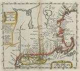
A new map of New England and …
note:
…., and covers
N.Y
. as far west as the
Hudson
River
Valley.
New England and New York
note:
Covers
Hudson
River
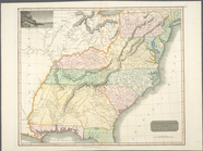
Southern provinces of the Uni…
note:
… of the
Hudson
River
.
A plan of Fort Montgomery & F…
note:
… map: Part of
Hudsons
River
, shewing