Click to visit the main New York Public Library Homepage
The New York Public Library
Digital Collections
About Digital Collections
Browse
Search only public domain materials
Items
Collections
Divisions
Home
Search
Browse
About
Search only public domain materials
Items
Collections
Divisions
Digital Collections
Using Images
Using Data
Collections
Charting America: Maps from the Lawrence H. Slaughter Collection and Others
Charting America: Maps from the Lawrence H. Slaughter Collection and Others
Navigation
Filters
Charting America: Maps from the Lawrence H. Slaughter Collection and Others
Previous
The south part of Virginia, now the north part of Carolina
0
Atlases, gazetteers, guidebooks and other books
377
Maps of the World
16
Maps of the Oceans
24
Maps of North and South America
23
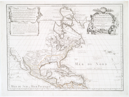
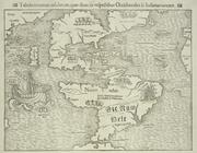
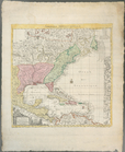
Maps of North America.
551
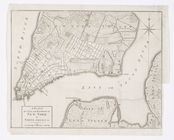
Maps of New York City and State
1340
Lawrence H. Slaughter Collection of English maps, charts, globes, books and atlases
1020
John H. Levine Collection
60
More
Show filters
Hide filters
Show Only Public Domain
topic
Atlases, British
7
Nautical charts
4
Atlases
2
Coasts
2
Cod fisheries
2
More
Less
name
Bowles, John, 1701-1779
2
Bowles, Thomas, -1767
2
Faden, William, 1749-1836
2
Godbid, Anne
2
Holland, N., Captain
2
More
Less
collection
x
Lawrence H. Slaughter Collection of English maps, charts, globes, books and atlases
place
x
Maps
Early works to 1800
21
North America
11
America
4
Caribbean Area
4
More
Less
genre
Maps
29
publisher
Printed at the Theater,
2
Printed by A. Godbid and J. Playford, for John Seller ...,
2
Rob[er]t Laurie & James Whittle, No. 53 Fleet Street
2
Sold by H. Moll over against Deverux Court in ye Strand ...,
2
And are to be sold at his shopps in Wapping at the Hermitage and in Exchange-Alley near the Royall-Exchange ..
1
More
Less
division
Map Division
29
type
cartographic
29
Date Range
to
29 results found for:
x
North America?tab=filter
Filtering on:
x
Place
: Maps
x
Collection
: 6a373d50-c5d3-012f-a6fb-58d385a7bc34
Sort by:
Relevance
Title
Date created
Date digitized
Sequence
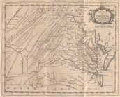
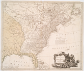
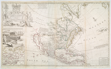
A new map of Virginia from th…
note:
LC Maps of
North
America
, 1750-1789, 1436
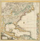
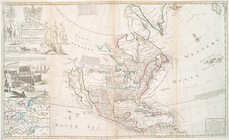
A map of Florida and ye Great…
note:
Covers eastern
North
America
from
A new map of
North
America
shewing its
collection:
North
America
.
… in
America
A chart of the West Indies fr…
America
.
note:
…, P.D. Mapping of
North
America
, 360
m
A chart of the West Indias fr…
m
A chart of the West Indias fr…
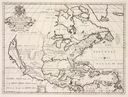
The
north
west part of
America
note:
Covers northeastern
North
America
, from
… States of
North
America
note:
Oriented with
north
to the upper right.
…) of the
North
American Coast
note:
… and harbours of
North
America
Carte de la Louisiane, Maryla…
note:
LC Maps of
North
America
, 1750-1789, 1386
Carte du Canada et de la Loui…
note:
LC Maps of
North
America
, 1750-1789, 72
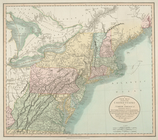
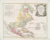
The United States of
North
America
note:
LC Maps of
North
America
, 1750-1789, 733
Canada et Louisiane
note:
LC Maps of
North
America
, 1750-1789, 34
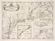
Amerique septentrionale : sui…
… of the United States of
North
America
: containing those
note:
Phillips. List of maps of
America
, p. 875
A chart of Delawar River from…
note:
LC Maps of
North
America
, 1750-1789, 1369
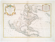
This map of
North
America
according to ye
This map of
North
America
according to ye
Amerique septentrionale : div…
America
Septentrionalis concinnata juxta
L'Amerique Septentrionale : d…
note:
Phillips. Maps of
America
, p. 564
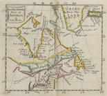
Tabula nouarum insularum, qua…
note:
Burden, P.D. Mapping of
North
America
… of
America
: divided into
North
and South and West
note:
Includes inset "The supplement to
North
America
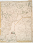
A plan of Fort Montgomery & F…
note:
… in LC Maps of
North
America
, 1750-1789, 1191.
… in
North
America
… of
North
America
note:
…, in the Southern Provinces of
North
America
. 1787. Opp. p. 1.
Amerique septentrionale : sui…
note:
… edge:
America
.
End of results
|
Top