Click to visit the main New York Public Library Homepage
The New York Public Library
Digital Collections
About Digital Collections
Browse
Search only public domain materials
Items
Collections
Divisions
Home
Search
Browse
About
Search only public domain materials
Items
Collections
Divisions
Digital Collections
Using Images
Using Data
Collections
Charting America: Maps from the Lawrence H. Slaughter Collection and Others
Charting America: Maps from the Lawrence H. Slaughter Collection and Others
Navigation
Filters
Charting America: Maps from the Lawrence H. Slaughter Collection and Others
Previous
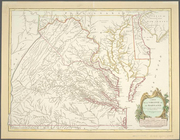
The south part of Virginia, now the north part of Carolina
0
Atlases, gazetteers, guidebooks and other books
377
Maps of the World
16
Maps of the Oceans
24
Maps of North and South America
23
Maps of North America.
551
Maps of New York City and State
1340
Lawrence H. Slaughter Collection of English maps, charts, globes, books and atlases
1020
John H. Levine Collection
60
More
Show filters
Hide filters
Show Only Public Domain
topic
Coasts
4
Nautical charts
3
Atlases
1
Atlases, British
1
name
Fry, Joshua, approximately 1700-1754
3
Jefferson, Peter, 1708-1757
3
Robert de Vaugondy, Gilles, 1688-1766
3
Visscher, Nicolaes, 1618-1679
3
Aa, Pieter van der, 1659-1733
2
More
Less
collection
Lawrence H. Slaughter Collection of English maps, charts, globes, books and atlases
15
John H. Levine Collection
3
place
x
Middle Atlantic States
Virginia
8
New England
7
Maryland
5
Maps
4
More
Less
genre
Maps
18
publisher
s.n.,
2
And are to be sold at his shopps in Wapping at the Hermitage and in Exchange-Alley near the Royall-Exchange ..
1
By Pieter vander Aa
1
Chez Brocas
1
Chez Delamarche?,
1
More
Less
division
Map Division
18
type
cartographic
18
Date Range
to
18 results found for:
x
Virginia?tab=filter
Filtering on:
x
Place
: Middle Atlantic States
Sort by:
Relevance
Title
Date created
Date digitized
Sequence
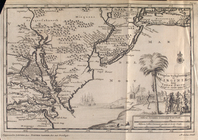
D'Engelze volkplanting in Vir…
Part of North America: compre…
collection:
…, New-England,
Virginia
…, New-Jarsey,
Virginia
… orientale della
Virginia
, e
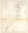
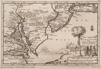
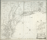
Carte réduite du Sud des État…
abstract:
Covers Delaware, Maryland,
Virginia
, North
A map of that part of America…
note:
… section of
Virginia
.
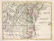
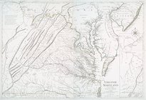
Carte de la Virginie et du Ma…
note:
… of
Virginia
and Maryland
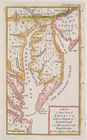
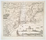
Virginie, Maryland : en 2 feu…
note:
Described in: Fry & Jefferson map of
Virginia
Virginia
, Maryland, Pennsilvania, east & west New
Virginia
, Maryland, Pennsilvania, east & west New
D'Engelze volkplanting in Vir…
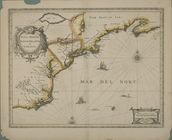
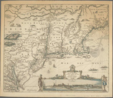
Nova Anglia, Novum Belgium, et
Virginia
.
…, Maryland, and
Virginia
.
note:
…, and eastern
Virginia
.
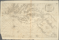
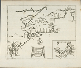
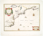
Costes et rivieres de Virgini…
… partis
Virginiae
tabula
Carte de la Virginie et du Ma…
note:
Covers
Virginia
, Maryland, and "De La War
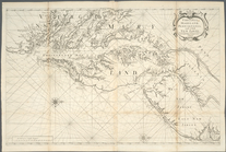
Nova Anglia, Novum Belgium, et
Virginia
.
… partis
Virginiae
tabula
End of results
|
Top