Click to visit the main New York Public Library Homepage
The New York Public Library
Digital Collections
About Digital Collections
Browse
Search only public domain materials
Items
Collections
Divisions
Home
Search
Browse
About
Search only public domain materials
Items
Collections
Divisions
Digital Collections
Using Images
Using Data
Collections
Charting America: Maps from the Lawrence H. Slaughter Collection and Others
Charting America: Maps from the Lawrence H. Slaughter Collection and Others
Navigation
Filters
Charting America: Maps from the Lawrence H. Slaughter Collection and Others
Previous
The south part of Virginia, now the north part of Carolina
0
Atlases, gazetteers, guidebooks and other books
377
Maps of the World
16
Maps of the Oceans
24
Maps of North and South America
23
Maps of North America.
551
Maps of New York City and State
1340
Lawrence H. Slaughter Collection of English maps, charts, globes, books and atlases
1020
John H. Levine Collection
60
More
Show filters
Hide filters
Show Only Public Domain
topic
Colonies
4
Geography
2
History
1
Smallpox
1
name
Childe, Timothy
3
Moll, Herman, -1732
3
Falconer, Robert, active 1700
2
Jefferys, Thomas, d. 1771
2
Luyts, Jan, 1655-1721
2
More
Less
collection
Lawrence H. Slaughter Collection of English maps, charts, globes, books and atlases
9
Maps of the Oceans
1
place
x
North America
America
4
Great Britain
3
France
2
United States
2
More
Less
genre
Maps
10
publisher
Printed for Timothy Childe at the White Hart at the West-end of St. Paul's Church-yard
2
Chez G. Broedelet
1
Chez Iean Covens & Corneille Mortier
1
Printed for Daniel Browne ... , John Senex ..
1
Printed for John and Paul Knapton
1
More
Less
division
Map Division
10
type
cartographic
10
Date Range
to
10 results found for:
x
Atlantic Coast (North America)?tab=filter
Filtering on:
x
Place
: North America
Sort by:
Relevance
Title
Date created
Date digitized
Sequence
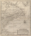
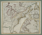
The English empire in
America
, Newfound-land
note:
…
Atlantic
Seaboard.
m
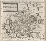
The isle of California, New M…
note:
… of
North
America
, but does not cover East
Coast
.
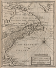
The English Empire in
America
, Newfound-land
note:
… on the
coasts
, and Bermudas.
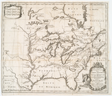
North
America
from the French of Mr. D'Anville
note:
…
Atlantic
Seaboard.
… settlements in
North
America
note:
… topography of
North
America
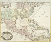
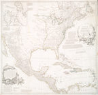
Carte du Mexique et de la Flo…
note:
…
America
from the
Atlantic
coast
to the Gulf
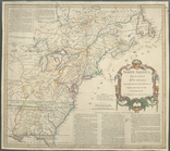
A new map of the English empire in
America
note:
… of the
coasts
& isles of Europe, Africa and
America
.
North
America
from the French of Mr. D'Anville :…
note:
…
Atlantic
Seaboard.
Carte d'un tres grand pais no…
note:
Wagner, H. R. Cartog. NW
coast
, II, 452
North
America
note:
…
Atlantic
Seaboard.