Click to visit the main New York Public Library Homepage
The New York Public Library
Digital Collections
About Digital Collections
Browse
Search only public domain materials
Items
Collections
Divisions
Home
Search
Browse
About
Search only public domain materials
Items
Collections
Divisions
Digital Collections
Using Images
Using Data
Collections
Charting America: Maps from the Lawrence H. Slaughter Collection and Others
Charting America: Maps from the Lawrence H. Slaughter Collection and Others
Navigation
Filters
Charting America: Maps from the Lawrence H. Slaughter Collection and Others
Previous
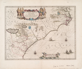
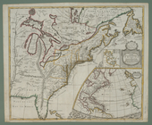
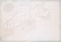
The south part of Virginia, now the north part of Carolina
0
Atlases, gazetteers, guidebooks and other books
377
Maps of the World
16
Maps of the Oceans
24
Maps of North and South America
23
Maps of North America.
551
Maps of New York City and State
1340
Lawrence H. Slaughter Collection of English maps, charts, globes, books and atlases
1020
John H. Levine Collection
60
More
Show filters
Hide filters
Show Only Public Domain
topic
Nautical charts
26
Coasts
7
Pilot guides
5
Atlases, British
4
Colonies
4
More
Less
name
Des Barres, Joseph F. W. (Joseph Frederick Wallet), 1729-1824
6
Blunt, Edmund M. (Edmund March), 1770-1862
5
Blunt, G. W. (George William), 1802-1878
5
Hooker, William
5
Moll, Herman, -1732
5
More
Less
collection
Lawrence H. Slaughter Collection of English maps, charts, globes, books and atlases
46
John H. Levine Collection
6
Atlases, gazetteers, guidebooks and other books
1
Maps of New York City and State
1
Maps of North and South America
1
More
Less
place
Atlantic Coast (North America)
17
North America
10
America
7
Caribbean Area
7
Atlantic Coast (South America)
6
More
Less
genre
Maps
56
Nautical charts
2
Prints
1
publisher
Pub. by E.M. Blunt for W. Hooker
5
By Pieter Goos, op de Texelse Kay, naest de Rams-koy, in de Zee-Spiegel
2
Chez Cóvens & Mortier
2
Printed by A. Godbid and J. Playford, for John Seller ...,
2
Printed for Timothy Childe at the White Hart at the West-end of St. Paul's Church-yard
2
More
Less
division
Map Division
56
type
cartographic
56
still image
1
Date Range
to
56 results found for:
x
Atlantic Coast (North America)?tab=filter
Filtering on:
x
Rights
: Public Domain
Sort by:
Relevance
Title
Date created
Date digitized
Sequence
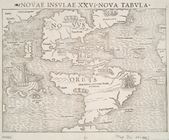
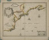
Novae insvlae XXVI nova tabvla
note:
…, with northeast
coast
of Asia and west
coast
of Africa.
Part of
North
America
collection:
… the sea-
coasts
, capes, head-lands
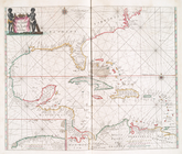
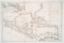
A chart of the West Indies fr…
note:
…
Atlantic
Seaboard.
… of the
coast
, countries
note:
…
Atlantic
Seaboard.
Pascaerte vande Vlaemsche, So…
abstract:
Oriented with
north
to the left. Includes
Pascaerte van Westindien : de…
note:
Covers
coast
of
North
America
as far
m
A chart of the West Indias fr…
note:
…
Atlantic
Seaboard.
m
A chart of the West Indias fr…
note:
…
Atlantic
Seaboard.
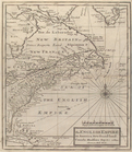
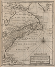
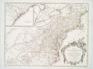
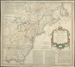
The English empire in
America
, Newfound-land
note:
…
Atlantic
Seaboard.
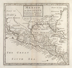
Mexico, or, New Spain : divid…
note:
Covers
North
America
as far
north
m
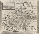
The isle of California, New M…
note:
… of
North
America
, but does not cover East
Coast
.
The English Empire in
America
, Newfound-land
note:
… on the
coasts
, and Bermudas.
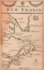
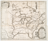
Canada, or, New France
note:
…, and the
Atlantic
coast
of
North
America
as far south
North
America
from the French of Mr. D'Anville
note:
…
Atlantic
Seaboard.
Chart of Long Island Sound, 1…
note:
…"Engraved for The American
coast
pilot."…
Entrance to New York Bay from…
note:
…"Engraved for The American
coast
pilot. 10th
Nautical chart of Little Egg …
note:
…"Engraved for The American
coast
pilot."…
The Bay and river of Delaware
note:
…"Engraved for The American
coast
pilot."…
Chart of the entrance to Ches…
note:
…"Engraved for The American
coast
pilot."…
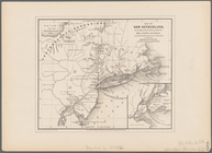
Map of New Netherland: accord…
note:
Covers
Atlantic
coast
from New England
… settlements in
North
America
note:
… topography of
North
America
… the islands in the
North
Sea
note:
Also covers
Atlantic
coast
of Virginia
… of the
coast
of New York, New
note:
LC Maps of
North
America
, 1750-1789, 766
…) of the
North
American
Coast
note:
…: Charts N.A.
Coast
1799
…) of the
North
American
Coast
note:
…: American
Coast
by Laurie
A chart of the
coast
of
America
: from
note:
…
Atlantic
Seaboard.
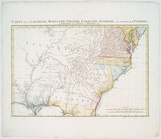
Carte de la Louisiane, Maryla…
note:
…
Atlantic
Seaboard.
Virginiae partis australis, e…
note:
Covers
Atlantic
Coast
from Virginia
Carte de la Louisiane, Maryla…
note:
LC Maps of
North
America
, 1750-1789, 1386
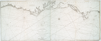
Terra nova, ac maris tractus …
note:
…, and the
coasts
of northeastern
North
America
… : describing part of the
coasts
note:
Covers
Atlantic
Ocean between N 620
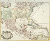
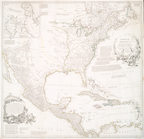
Carte du Mexique et de la Flo…
note:
…
America
from the
Atlantic
coast
to the Gulf
Nova Anglia, Novum Belgium, e…
note:
…
coast
of
North
America
A chart of the Atlantick Ocea…
note:
Covers east
coast
of
North
America
from
Partie de l'Amérique septentr…
note:
… the
Atlantic
coast
A new map of the English empire in
America
note:
… of the
coasts
& isles of Europe, Africa and
America
.
Pas kaart van West Indien : b…
note:
…
coast
of
North
America
North
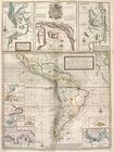
America
from the French of Mr. D'Anville :…
note:
…
Atlantic
Seaboard.
A new chart of
America
with the harbors
note:
Nautical chart of the east
coast
of the U.S
Carte d'un tres grand pais no…
note:
Wagner, H. R. Cartog. NW
coast
, II, 452
North
America
note:
…
Atlantic
Seaboard.
A chart of the sea
coast
of New Foundland
note:
…
Atlantic
Seaboard.
The
coast
of Nova Scotia, New England, New
note:
Appears in the author's
Atlantic
Neptune.
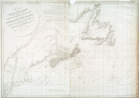
The
coast
of Nova Scotia, New England, New
note:
… Maps of
North
America
A chart of
North
and South
America
note:
… with the adjacent
coast
of Asia
m
A chart of
North
and South
America
note:
… with the adjacent
coast
of Asia
[A chart of New York Island &
North
note:
Covers the
coast
of Long Island from Eaton
A chart of New York Island &
North
River
note:
Covers the
coast
of Long Island from Eaton
… mariners of
America
: this chart of their
coast
note:
…
Atlantic
Seaboard.
m
Sable Island
collection:
The
Atlantic
Neptune, published