Click to visit the main New York Public Library Homepage
The New York Public Library
Digital Collections
About Digital Collections
Browse
Search only public domain materials
Items
Collections
Divisions
Home
Search
Browse
About
Search only public domain materials
Items
Collections
Divisions
Digital Collections
Using Images
Using Data
Collections
Charting America: Maps from the Lawrence H. Slaughter Collection and Others
Charting America: Maps from the Lawrence H. Slaughter Collection and Others
Navigation
Filters
Charting America: Maps from the Lawrence H. Slaughter Collection and Others
Previous
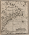
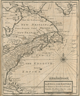
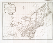
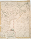
The south part of Virginia, now the north part of Carolina
0
Atlases, gazetteers, guidebooks and other books
377
Maps of the World
16
Maps of the Oceans
24
Maps of North and South America
23
Maps of North America.
551
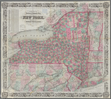
Maps of New York City and State
1340
Lawrence H. Slaughter Collection of English maps, charts, globes, books and atlases
1020
John H. Levine Collection
60
More
Show filters
Hide filters
Show Only Public Domain
topic
Railroads
21
Administrative and political divisions
11
Colonies
11
Canals
6
Geography
4
More
Less
name
Moll, Herman, -1732
7
Lotter, Matthäus Albrecht, 1741-1810
6
Lotter, Tobias Conrad, 1717-1777
6
Bowles, John, 1701-1779
5
Weed, Parsons & Co
5
More
Less
collection
Lawrence H. Slaughter Collection of English maps, charts, globes, books and atlases
35
Maps of New York City and State
33
John H. Levine Collection
9
Atlases, gazetteers, guidebooks and other books
7
place
North America
30
New York (State)
29
Canada
16
America
13
United States
13
More
Less
genre
Maps
84
Cadastral maps
1
Early works to 1800
1
Facsimiles
1
Geological maps
1
More
Less
publisher
Tobias Conrad Lotter?
5
publisher not identified
5
Lith. by Weed, Parsons & Co
3
P. Goos
3
Printed for Timothy Childe at the White Hart at the West-end of St. Paul's Church-yard
3
More
Less
division
Map Division
84
type
cartographic
83
still image
1
text
1
Date Range
to
84 results found for:
x
Canada?tab=filter
Filtering on:
x
Rights
: Public Domain
Sort by:
Relevance
Title
Date created
Date digitized
Sequence
… of
Canada
… of Upper
Canada
m
North America divided into it…
note:
…,
Canada
, N. Fpance [sic
m
A new and exact map of the do…
note:
… beavers of
Canada
m
…, Mississipi,
Canada
and New
America.
note:
In upper right corner:
Tab
. 46.
…,
Canada
, Hudsons Bay, &c
m
… of
Canada
.
…,
Canada
, Hudsons Bay, &c
note:
… of
Canada
, viz. New-England
…,
Canada
, Hudsons Bay, &c
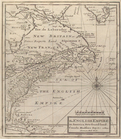
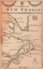
Canada
, or, New France
note:
Covers eastern
Canada
, southern
… Francia o
Canada
Parte Orientale del
Canada
, Nuova Scozia
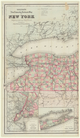
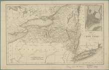
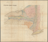
The state of New York from th…
note:
… of bordering states and
Canada
.
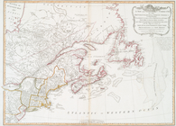
A new map of Upper and Lower
Canada
, 1794.
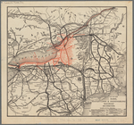
Colton's railroad & township …
On the Borders of
Canada
... resemblance
Nieuwe en nauwkeurige kaart v…
Agricultural and geological m…
note:
…. Johns,
Canada
m
Colton's new township railroa…
Colton's railroad & township …
… of the adjoining states &
Canada
Map of the Rome, Watertown an…
note:
… States and part of
Canada
.
m
Post route map of the State o…
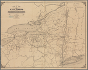
Map of the rail roads of the …
note:
… of
Canada
.
Map of the rail roads of the …
note:
… of
Canada
.
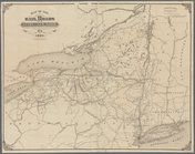
Revised map of the rail roads…
note:
… and Quebec,
Canada
.
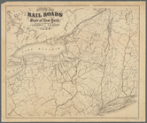
Map of the rail roads and can…
note:
… of
Canada
.
Map of the rail roads of the …
note:
… and provinces of
Canada
.
Map of the railroads of the S…
note:
… and provinces of
Canada
.
m
Geological map of the State o…
note:
…'s,
Canada
… of
Canada
…, and
Canada
note:
… States or
Canada
… of the adjoining states &
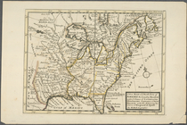
Canada
United States of America.
note:
… to Early
Canada
and Mexico.
Carte du
Canada
et de la Louisiane qui
Canada
, Louisiane et terres angloises
… septentrionale savoir le
Canada
… septentrionale voir le
Canada
, la
… septentrionale voir le
Canada
, la
… septentrionale voir le
Canada
, la
Carte de la Nouvelle France: …
Canada
et Louisiane
note:
On verso of the map, written in ink:
Canada
Theatre de la guerre en Améri…
note:
Later ed. of the author's
Canada
et
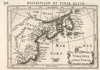
Virginia et Nova Francia
Le
Canada
, ou Nouvelle France, la Floride
Partie orientale du
Canada
ou de la Nouvelle
note:
Kershaw, K.A. Early printed maps of
Canada
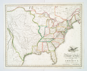
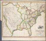
United States of America
note:
… of
Canada
and Mexico.
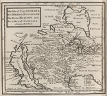
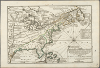
A new map of ye north parts o…
… comprehending eastern
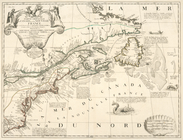
Canada