Click to visit the main New York Public Library Homepage
The New York Public Library
Digital Collections
About Digital Collections
Browse
Search only public domain materials
Items
Collections
Divisions
Home
Search
Browse
About
Search only public domain materials
Items
Collections
Divisions
Digital Collections
Using Images
Using Data
Collections
Charting America: Maps from the Lawrence H. Slaughter Collection and Others
Charting America: Maps from the Lawrence H. Slaughter Collection and Others
Navigation
Filters
Charting America: Maps from the Lawrence H. Slaughter Collection and Others
Previous
The south part of Virginia, now the north part of Carolina
0
Atlases, gazetteers, guidebooks and other books
377
Maps of the World
16
Maps of the Oceans
24
Maps of North and South America
23
Maps of North America.
551
Maps of New York City and State
1340
Lawrence H. Slaughter Collection of English maps, charts, globes, books and atlases
1020
John H. Levine Collection
60
More
Show filters
Hide filters
Show Only Public Domain
topic
Discovery and exploration
3
Indians of North America
3
Discoveries in geography
1
name
Blaeu, Joan, 1596-1673
3
Blaeu, Willem Janszoon, 1571-1638
3
White, John, fl. 1585-1593
3
Leth, Andries de, 1662-1731
1
Leth, Hendrik de, 1703-1766
1
collection
x
Maps of North and South America
place
America
4
Western Hemisphere
2
Atlantic Ocean
1
Pacific Ocean
1
genre
Maps
4
publisher
Joan Blaeu
3
Donnè au public, par And. & Henry de Leth ... sur le Pont de la Bourse au Pescheur
1
division
Map Division
4
type
cartographic
4
text
2
Date Range
to
4 results found for:
x
Mexico?tab=filter
Filtering on:
x
Collection
: 5c9f7820-c6b9-012f-b035-58d385a7bc34
Sort by:
Relevance
Title
Date created
Date digitized
Sequence
m
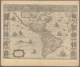
Americae nova tabula
note:
…, Cartegena,
Mexico
City
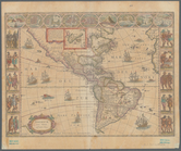
m
Americae nova tabula
note:
…, Cartegena,
Mexico
City
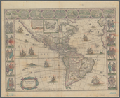
m
Americae nova tabula
note:
…, Cartegena,
Mexico
City
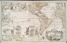
Carte nouvelle de la mer du S…
note:
… ville de
Mexico
-- Istme