Click to visit the main New York Public Library Homepage
The New York Public Library
Digital Collections
About Digital Collections
Browse
Search only public domain materials
Items
Collections
Divisions
Home
Search
Browse
About
Search only public domain materials
Items
Collections
Divisions
Digital Collections
Using Images
Using Data
Collections
Charting America: Maps from the Lawrence H. Slaughter Collection and Others
Charting America: Maps from the Lawrence H. Slaughter Collection and Others
Navigation
Filters
Charting America: Maps from the Lawrence H. Slaughter Collection and Others
Previous
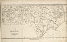
The south part of Virginia, now the north part of Carolina
0
Atlases, gazetteers, guidebooks and other books
377
Maps of the World
16
Maps of the Oceans
24
Maps of North and South America
23
Maps of North America.
551
Maps of New York City and State
1340
Lawrence H. Slaughter Collection of English maps, charts, globes, books and atlases
1020
John H. Levine Collection
60
More
Show filters
Hide filters
Show Only Public Domain
topic
x
Geography
Atlases
1
Bible
1
Colonies
1
Constellations
1
More
Less
name
Childe, Timothy
5
Falconer, Robert, active 1700
5
Luyts, Jan, 1655-1721
5
Moll, Herman, -1732
5
Morse, Jedidiah, 1761-1826
4
More
Less
collection
x
Lawrence H. Slaughter Collection of English maps, charts, globes, books and atlases
place
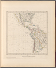
North America
6
North America -- Maps -- Early works to 1800
5
United States
4
Central America
2
Great Britain
2
More
Less
genre
Maps
13
publisher
Printed for Timothy Childe at the White Hart at the West-end of St. Paul's Church-yard
5
Printed for J. Stockdale
4
Chapman and Hall
1
Printed by S. Palmer, for R. Knaplock, J. and B. Sprint, S. Burroughs, D. Midwinter, A. Bettesworth, R. Ford, A. Ward and J. Clark,
1
Printed for Edward and Charles Dilly in the Poultrey, and George Robinson, Pater-noster Row,
1
More
Less
division
Map Division
13
type
cartographic
13
Date Range
to
13 results found for:
x
North America?tab=filter
Filtering on:
x
Collection
: 6a373d50-c5d3-012f-a6fb-58d385a7bc34
x
Topic
: Geography
Sort by:
Relevance
Title
Date created
Date digitized
Sequence
m
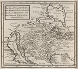
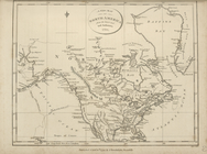
The isle of California, New M…
note:
Covers most of
North
America
, but does
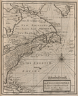
The English Empire in
America
, Newfound-land
note:
Covers eastern
North
America
.
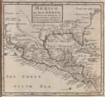
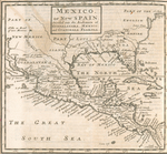
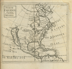
Mexico, or, New Spain : divid…
note:
Covers
North
America
as far
north
The English empire in
America
, Newfound-land
note:
Covers eastern
North
America
.
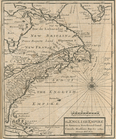
Mexico, or, New Spain : divid…
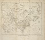
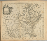
A new map of
North
America
from the latest
… dominions in
North
America
A map of the states of Virginia,
North
Carolina
A map of
North
Carolina, from the best
North
America
North
America
: according to the latest
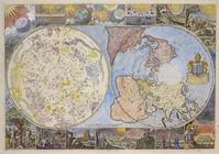
World on gnomonic projection …
Map of the heavens and the ea…
note:
… centered on
North
Pole
End of results
|
Top