Click to visit the main New York Public Library Homepage
The New York Public Library
Digital Collections
About Digital Collections
Browse
Search only public domain materials
Items
Collections
Divisions
Home
Search
Browse
About
Search only public domain materials
Items
Collections
Divisions
Digital Collections
Using Images
Using Data
Collections
Charting America: Maps from the Lawrence H. Slaughter Collection and Others
Charting America: Maps from the Lawrence H. Slaughter Collection and Others
Navigation
Filters
Charting America: Maps from the Lawrence H. Slaughter Collection and Others
Previous
The south part of Virginia, now the north part of Carolina
0
Atlases, gazetteers, guidebooks and other books
377
Maps of the World
16
Maps of the Oceans
24
Maps of North and South America
23
Maps of North America.
551
Maps of New York City and State
1340
Lawrence H. Slaughter Collection of English maps, charts, globes, books and atlases
1020
John H. Levine Collection
60
More
Show filters
Hide filters
Show Only Public Domain
topic
World maps
4
Religions
2
Atmospheric temperature
1
Climatology
1
Ethnology
1
More
Less
name
Woodbridge, William C. (William Channing), 1794-1845
2
Bassett, Thomas
1
Chiswell, Richard
1
Humboldt, Alexander von, 1769-1859
1
Huntington, Eleazar (1789-1852 )
1
More
Less
collection
x
Maps of the World
place
Maps
4
genre
Maps
4
publisher
William C. Woodbridge
2
Are to be sold by Tho. Bassett in Fleet Street and Ric. Chiswell in St. Pauls Church yard,
1
Published by H. Frederick Sumner
1
division
Map Division
4
type
cartographic
4
Date Range
to
4 results found for:
x
Middle Atlantic States?tab=filter
Filtering on:
x
Collection
: Maps of the World
Sort by:
Relevance
Title
Date created
Date digitized
Sequence
… and
states
: also
note:
… to Early Maps of the
Middle
Atlantic
Seaboard.
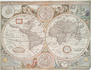
A new and accurat map of the …
note:
Imprint on map indicates this is 4th
state
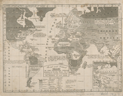
Isothermal chart, or, View of…
note:
…. Woodbridge of the
state
Moral and political chart of …
note:
…. Woodbridge of the
state