Click to visit the main New York Public Library Homepage
The New York Public Library
Digital Collections
About Digital Collections
Browse
Search only public domain materials
Items
Collections
Divisions
Home
Search
Browse
About
Search only public domain materials
Items
Collections
Divisions
Digital Collections
Using Images
Using Data
Collections
Charting America: Maps from the Lawrence H. Slaughter Collection and Others
Charting America: Maps from the Lawrence H. Slaughter Collection and Others
Navigation
Filters
Charting America: Maps from the Lawrence H. Slaughter Collection and Others
Previous
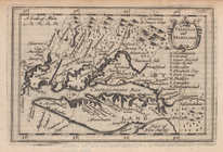
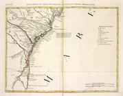
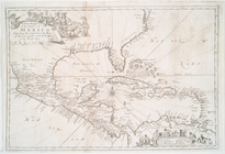
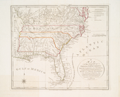
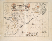
The south part of Virginia, now the north part of Carolina
0
Atlases, gazetteers, guidebooks and other books
377
Maps of the World
16
Maps of the Oceans
24
Maps of North and South America
23
Maps of North America.
551
Maps of New York City and State
1340
Lawrence H. Slaughter Collection of English maps, charts, globes, books and atlases
1020
John H. Levine Collection
60
More
Show filters
Hide filters
Show Only Public Domain
topic
Geography
7
Nautical charts
6
Atlases
3
Coasts
3
Colonies
3
More
Less
name
Moll, Herman, -1732
4
Childe, Timothy
3
Cóvens et Mortier
3
Laurie & Whittle
3
Stockdale, John, 1749?-1814
3
More
Less
collection
x
Lawrence H. Slaughter Collection of English maps, charts, globes, books and atlases
place
North America
11
Maps
7
America
6
North Carolina
6
Mexico
5
More
Less
genre
Maps
37
publisher
Presso Antonio Zatta
3
Chez Cóvens & Mortier
2
Printed for J. Stockdale
2
Printed for Tho. Basset ... and Ric. Chiswell ...,
2
Printed for Timothy Childe at the White Hart at the West-end of St. Paul's Church-yard
2
More
Less
division
Map Division
37
type
cartographic
36
still image
1
text
1
Date Range
to
37 results found for:
x
Florida?tab=filter
Filtering on:
x
Collection
: Lawrence H. Slaughter Collection of English maps, charts, globes, books and atlases
Sort by:
Relevance
Title
Date created
Date digitized
Sequence
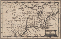
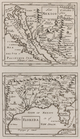
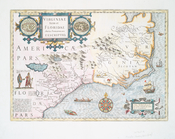
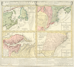
Virginia and Maryland.
collection:
…, ... Carolina,
Florida
Newengland and New York.
collection:
…, ... Carolina,
Florida
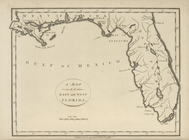
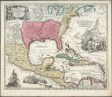
A map of
Florida
and ye Great Lakes
note:
… the Great Lakes to
Florida
A chart of Delaware Bay and R…
collection:
…,
Florida
, and the Havanna
m
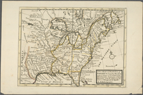
North America divided into it…
note:
…, Virginia, Carolina,
Florida
m
A new and exact map of the do…
note:
… of
Florida
...
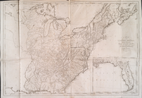
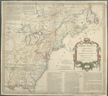
A map of the United States : …
note:
Includes inset of
Florida
.
America.
note:
In upper right corner:
Tab
. 46.
…,
Florida
.
…,
Florida
.
…,
Florida
.
North America from the French…
abstract:
… to northern
Florida
…
Florida
Orientale.
…, della
Florida
, della
Parte Orientale della
Florida
, della
New Mexico ;
Florida
.
… and West
Florida
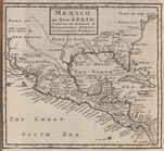
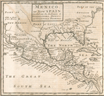
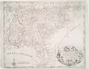
A map of the East and West
Florida
.
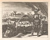
The Inhabitants of
Florida
are an Olive
note:
…"The Inhabitants of
Florida
are an Olive
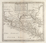
A new mapp of the Empire of M…
note:
…, Carolina and
Florida
.
… Philadelphia and
Florida
note:
… Philadelphia and
Florida
… of
Florida
respectfully
To the members of the Nautica…
note:
… York to
Florida
… or Gulf of
Florida
note:
…
Florida
to mouth
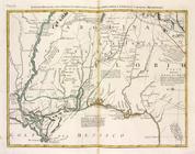
Carte de la Louisiane, Maryla…
abstract:
…. Augustine in
Florida
Virginiae partis australis, et
Floridae
note:
… to
Florida
.
Carte de la Louisiane, Maryla…
abstract:
…. Augustine in
Florida
… and west
Florida
Virginiae item et
Floridae
Americae
note:
… of a
Florida
Indian village
…,
Floridae
, Novae Angliae
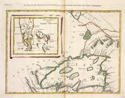
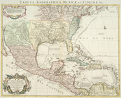
Carte du Mexique et de la Flo…
collection:
Tabula geographica Mexicæ et
Floridæ
&c.
Dominia Anglorum in America S…
note:
…
Florida
.
Pas kaart van West Indien : b…
note:
… to
Florida
, Gulf Coast
North America from the French…
abstract:
… to northern
Florida
A new map of ye north parts o…
note:
… to
Florida
and as far west
… and East
Florida
from
Virginiae partis australis et
Floridae
partis
End of results
|
Top