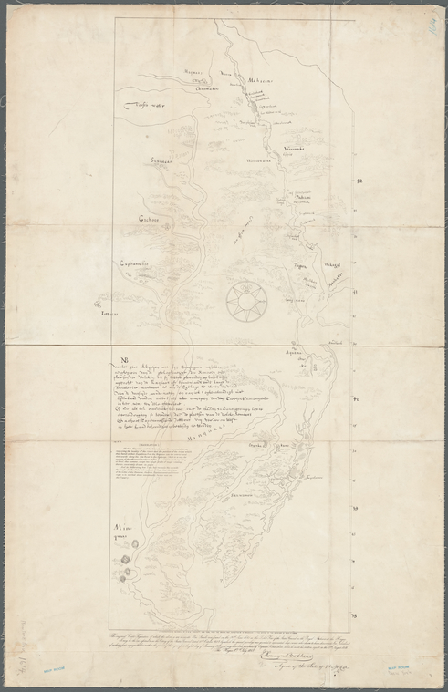
TitleMap of New Netherland
NamesBrodhead, John Romeyn, 1814-1873 (Associated name)G. & W. Endicott (Firm) (Lithographer)
CollectionMaps of New York City and State
Whole
Dates / OriginDate Issued: 1841 (Inferred)Place: New York, N.Y.?Publisher: publisher not identified
Library locationsLionel Pincus and Princess Firyal Map DivisionShelf locator: Map Div. 16-748
TopicsIndians of North America -- New NetherlandNew Netherland -- Maps -- Early works to 1800 -- Facsimiles
GenresMapsEarly mapsFacsimiles
NotesStatement of responsibility: Lithographed in fac-simile by G. & W. Endicott, New York, from the original map deposited by M. Brodhead in the office of the secretary of state at Albany.Content: Also shows the locations of various Indian tribes.Content: "The original Carte Figurative of which the above is an accurate fac-simile, was found on the 26th June 1841 in the Loket Kas of the States General in the Royal Archives at The Hague. It may be the one referred to in the Octroy of the States General dated the 11th October, 1614, by which the special privilege was granted to associated Ship owners, who claim to have discovered New Netherland, of making four voyages thither, within the period of three year from the first day of January, 1615; or it may have been presented by Captain Hendricksen, when he made his written report, on the 19th August 1616."Content: Includes text.Statement of responsibility: Map signed "The Hague, 27th July, 1841. J. Romeyn Brodhead, agent of the state of New York."Funding: Mapping the Nation (NEH grant, 2015-2018)
Physical DescriptionExtent: 1 map ; 85 x 36 cm, on sheet 95 x 61 cm
Type of ResourceCartographic
LanguagesDutch, FlemishEnglish
IdentifiersRLIN/OCLC: 953414399NYPL catalog ID (B-number): b21009990Other local Identifier: US136.1.04Universal Unique Identifier (UUID): bcbd47e0-34a8-0134-f4aa-00505686a51c
Rights StatementThe New York Public Library believes that this item is in the public domain under the laws of the United States, but did not make a determination as to its copyright status under the copyright laws of other countries. This item may not be in the public domain under the laws of other countries. Though not required, if you want to credit us as the source, please use the following statement, "From The New York Public Library," and provide a link back to the item on our Digital Collections site. Doing so helps us track how our collection is used and helps justify freely releasing even more content in the future.
Item timeline of events
-
-
-
-
-
-