

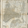
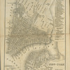
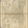
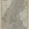
![Union County, Double Page Plate No. 1 [Map bounded by King St., Pennsylvania Ave., Parker Rd., Union Ave.]](https://s3.amazonaws.com/repo-transcoded-web-media-thumnails/3a16e350-c5ed-012f-910b-58d385a7bc34/3a16e350-c5ed-012f-910b-58d385a7bc34-00002.jpg)
![Union County, Double Page Plate No. 1 [Map bounded by King St., Pennsylvania Ave., Parker Rd., Union Ave.]](https://images.nypl.org/index.php?id=3997129&t=b)
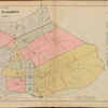
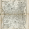
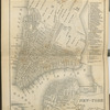
![Union County, Double Page Plate No. 2 [Map bounded by Parker Rd., Union Ave., Whitehead Pl., Westfield Ave., Bay Way Ave.]](https://s3.amazonaws.com/repo-transcoded-web-media-thumnails/3a6451d0-c5ed-012f-de49-58d385a7bc34/3a6451d0-c5ed-012f-de49-58d385a7bc34-00002.jpg)
![Union County, Double Page Plate No. 2 [Map bounded by Parker Rd., Union Ave., Whitehead Pl., Westfield Ave., Bay Way Ave.]](https://images.nypl.org/index.php?id=3997130&t=b)
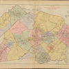
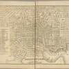
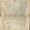
![Union County, Double Page Plate No. 3 [Map bounded by West Grand St., Broad St., Fay Ave.]](https://s3.amazonaws.com/repo-transcoded-web-media-thumnails/3ac5ea20-c5ed-012f-03fc-58d385a7bc34/3ac5ea20-c5ed-012f-03fc-58d385a7bc34-00002.jpg)
![Union County, Double Page Plate No. 3 [Map bounded by West Grand St., Broad St., Fay Ave.]](https://images.nypl.org/index.php?id=3997131&t=b)
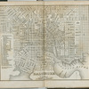
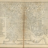
![Union County, Double Page Plate No. 4 [Map bounded by Burnet St., S. Union St., W. Jersey St., E. Jersey St., Reid St., 3rd Ave., Summer St.]](https://s3.amazonaws.com/repo-transcoded-web-media-thumnails/3b089a70-c5ed-012f-c38f-58d385a7bc34/3b089a70-c5ed-012f-c38f-58d385a7bc34-00002.jpg)
![Union County, Double Page Plate No. 4 [Map bounded by Burnet St., S. Union St., W. Jersey St., E. Jersey St., Reid St., 3rd Ave., Summer St.]](https://images.nypl.org/index.php?id=3997132&t=b)
![Union County, Double Page Plate No. 5 [Map bounded by Walnut St., North Ave., Henry St., Jaques St., E. Jersey St.]](https://s3.amazonaws.com/repo-transcoded-web-media-thumnails/3b586540-c5ed-012f-6715-58d385a7bc34/3b586540-c5ed-012f-6715-58d385a7bc34-00002.jpg)


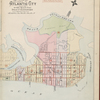
![Atlantic City, Double Page Plate No. 1 [Map bounded by Pacific Ave., Atlantic Ocean, Maryland Ave.]](https://images.nypl.org/index.php?id=3905954&t=b)
![Atlantic City, Double Page Plate No. 2 [Map bounded by Pacific Ave., Maryland Ave., Atlantic Ocean, Kentucky Ave.]](https://images.nypl.org/index.php?id=3905955&t=b)
![Atlantic City, Double Page Plate No. 3 [Map bounded by Pacific Ave., Kentucky Ave., Atlantic Ocean, Mississippi Ave.]](https://images.nypl.org/index.php?id=3905956&t=b)
![Atlantic City, Double Page Plate No. 4 [Map bounded by Atlantic Ave., Mississippi Ave., Atlantic Ocean, Stenton Pl.]](https://images.nypl.org/index.php?id=3905957&t=b)
![Atlantic City, Double Page Plate No. 5 [Map bounded by Vermont Ave., Mediterranean Ave., Atlantic Ocean, Pacific Ave.]](https://images.nypl.org/index.php?id=3905958&t=b)
![Atlantic City, Double Page Plate No. 6 [Map bounded by Vermont Ave., Pacific Ave., New Jersey Ave., Mediterranean Ave.]](https://images.nypl.org/index.php?id=3905959&t=b)
![Atlantic City, Double Page Plate No. 7 [Map bounded by New Jersey Ave., Pacific Ave., Pennsylvania Ave., Mediterranean Ave.]](https://images.nypl.org/index.php?id=3905960&t=b)
![Atlantic City, Double Page Plate No. 8 [Map bounded by Pennsylvania Ave., Pacific Ave., New York Ave., Mediterranean Ave.]](https://images.nypl.org/index.php?id=3905961&t=b)
![Atlantic City, Double Page Plate No. 9 [Map bounded by New York Ave., Pacific Ave., Ohio Ave., Mediterranean Ave.]](https://images.nypl.org/index.php?id=3905962&t=b)
![Atlantic City, Double Page Plate No. 10 [Map bounded by Ohio Ave., Pacific Ave., Mississippi Ave., Mediterranean Ave.]](https://images.nypl.org/index.php?id=3905963&t=b)
![Atlantic City, Double Page Plate No. 11 [Map bounded by Mississippi Ave., Atlantic Ave., California Ave., Beach Thoroughfare]](https://images.nypl.org/index.php?id=3905964&t=b)
![Atlantic City, Double Page Plate No. 12 [Map bounded by California Ave., Atlantic Ocean, Boston Ave., Beach Thoroughfare]](https://images.nypl.org/index.php?id=3905965&t=b)
- The Library Shop
- Privacy Policy
- Rules and Regulations
- Using the Internet
- Website Terms and Conditions
- Gifts of Materials to NYPL
-
© The New York Public Library, 2024
The New York Public Library is a 501(c)(3) | EIN 13-1887440
Lionel Pincus and Princess Firyal Map Division, The New York Public Library. "Atlas of Union County, New Jersey, 1906" The New York Public Library Digital Collections. 1906. https://digitalcollections.nypl.org/items/38b11ad0-c5ed-012f-7f90-58d385a7bc34
Lionel Pincus and Princess Firyal Map Division, The New York Public Library. "Atlas of Union County, New Jersey, 1906" New York Public Library Digital Collections. Accessed April 19, 2024. https://digitalcollections.nypl.org/items/38b11ad0-c5ed-012f-7f90-58d385a7bc34
Lionel Pincus and Princess Firyal Map Division, The New York Public Library. (1906). Atlas of Union County, New Jersey, 1906 Retrieved from https://digitalcollections.nypl.org/items/38b11ad0-c5ed-012f-7f90-58d385a7bc34
<ref name=NYPL>{{cite web | url=https://digitalcollections.nypl.org/items/38b11ad0-c5ed-012f-7f90-58d385a7bc34 | title=
(cartographic)
Atlas of Union County, New Jersey, 1906, (1906)|author=Digital Collections, The New York Public Library |accessdate=April 19, 2024 |publisher=The New York Public Library, Astor, Lenox, and Tilden Foundations}}</ref>
