


- The Library Shop
- Privacy Policy
- Rules and Regulations
- Using the Internet
- Website Terms and Conditions
- Gifts of Materials to NYPL
-
© The New York Public Library, 2024
The New York Public Library is a 501(c)(3) | EIN 13-1887440
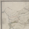
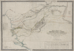
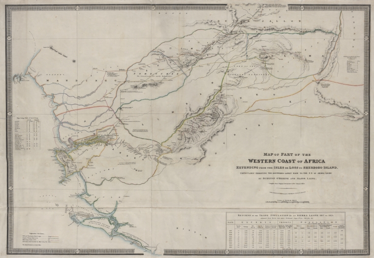
Schomburg Center for Research in Black Culture, Jean Blackwell Hutson Research and Reference Division, The New York Public Library. "Map of part of the western coast of Africa extending from the Isles de Loss to Sherboro Island, particularly exhibiting the discoveries lately made to the N.E. of Sierra Leone by Surgeon O'Beirne and Major Laing" The New York Public Library Digital Collections. 1873. https://digitalcollections.nypl.org/items/38c4ae30-fa28-0131-ca0d-58d385a7b928
Schomburg Center for Research in Black Culture, Jean Blackwell Hutson Research and Reference Division, The New York Public Library. "Map of part of the western coast of Africa extending from the Isles de Loss to Sherboro Island, particularly exhibiting the discoveries lately made to the N.E. of Sierra Leone by Surgeon O'Beirne and Major Laing" New York Public Library Digital Collections. Accessed April 27, 2024. https://digitalcollections.nypl.org/items/38c4ae30-fa28-0131-ca0d-58d385a7b928
Schomburg Center for Research in Black Culture, Jean Blackwell Hutson Research and Reference Division, The New York Public Library. (1873). Map of part of the western coast of Africa extending from the Isles de Loss to Sherboro Island, particularly exhibiting the discoveries lately made to the N.E. of Sierra Leone by Surgeon O'Beirne and Major Laing Retrieved from https://digitalcollections.nypl.org/items/38c4ae30-fa28-0131-ca0d-58d385a7b928
<ref name=NYPL>{{cite web | url=https://digitalcollections.nypl.org/items/38c4ae30-fa28-0131-ca0d-58d385a7b928 | title=
(cartographic)
Map of part of the western coast of Africa extending from the Isles de Loss to Sherboro Island, particularly exhibiting the discoveries lately made to the N.E. of Sierra Leone by Surgeon O'Beirne and Major Laing, (1873)
|author=Digital Collections, The New York Public Library |accessdate=April 27, 2024 |publisher=The New York Public Library, Astor, Lenox, and Tilden Foundations}}</ref>