


- The Library Shop
- Privacy Policy
- Rules and Regulations
- Using the Internet
- Website Terms and Conditions
- Gifts of Materials to NYPL
-
© The New York Public Library, 2024
The New York Public Library is a 501(c)(3) | EIN 13-1887440
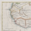
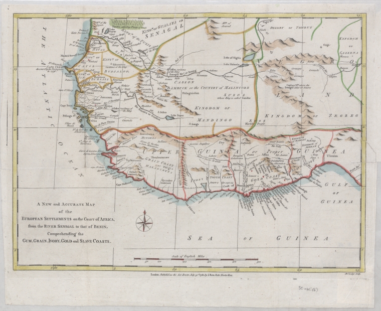
Schomburg Center for Research in Black Culture, Jean Blackwell Hutson Research and Reference Division, The New York Public Library. "A new and accurate map of the European settlements on the coast of Africa, from the River Senegal to that of Benin, comprehending the gum, grain, ivory, gold and slave coasts" The New York Public Library Digital Collections. 1781. https://digitalcollections.nypl.org/items/4ef1d920-fa28-0131-a087-58d385a7b928
Schomburg Center for Research in Black Culture, Jean Blackwell Hutson Research and Reference Division, The New York Public Library. "A new and accurate map of the European settlements on the coast of Africa, from the River Senegal to that of Benin, comprehending the gum, grain, ivory, gold and slave coasts" New York Public Library Digital Collections. Accessed April 27, 2024. https://digitalcollections.nypl.org/items/4ef1d920-fa28-0131-a087-58d385a7b928
Schomburg Center for Research in Black Culture, Jean Blackwell Hutson Research and Reference Division, The New York Public Library. (1781). A new and accurate map of the European settlements on the coast of Africa, from the River Senegal to that of Benin, comprehending the gum, grain, ivory, gold and slave coasts Retrieved from https://digitalcollections.nypl.org/items/4ef1d920-fa28-0131-a087-58d385a7b928
<ref name=NYPL>{{cite web | url=https://digitalcollections.nypl.org/items/4ef1d920-fa28-0131-a087-58d385a7b928 | title=
(cartographic)
A new and accurate map of the European settlements on the coast of Africa, from the River Senegal to that of Benin, comprehending  the gum, grain, ivory, gold and slave coasts, (1781)
|author=Digital Collections, The New York Public Library |accessdate=April 27, 2024 |publisher=The New York Public Library, Astor, Lenox, and Tilden Foundations}}</ref>