


- The Library Shop
- Privacy Policy
- Rules and Regulations
- Using the Internet
- Website Terms and Conditions
- Gifts of Materials to NYPL
-
© The New York Public Library, 2024
The New York Public Library is a 501(c)(3) | EIN 13-1887440
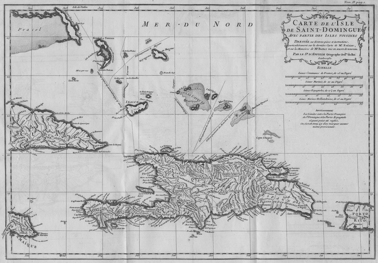
Schomburg Center for Research in Black Culture, Manuscripts, Archives and Rare Books Division, The New York Public Library. "Carte de L'Isle de Saint-Domingue Avec partie des Isles Voisines" The New York Public Library Digital Collections. 1731. https://digitalcollections.nypl.org/items/510d47da-7209-a3d9-e040-e00a18064a99
Schomburg Center for Research in Black Culture, Manuscripts, Archives and Rare Books Division, The New York Public Library. "Carte de L'Isle de Saint-Domingue Avec partie des Isles Voisines" New York Public Library Digital Collections. Accessed April 25, 2024. https://digitalcollections.nypl.org/items/510d47da-7209-a3d9-e040-e00a18064a99
Schomburg Center for Research in Black Culture, Manuscripts, Archives and Rare Books Division, The New York Public Library. (1731). Carte de L'Isle de Saint-Domingue Avec partie des Isles Voisines Retrieved from https://digitalcollections.nypl.org/items/510d47da-7209-a3d9-e040-e00a18064a99
<ref name=NYPL>{{cite web | url=https://digitalcollections.nypl.org/items/510d47da-7209-a3d9-e040-e00a18064a99 | title=
(cartographic)
Carte de L'Isle de Saint-Domingue Avec partie des Isles Voisines, (1731)
|author=Digital Collections, The New York Public Library |accessdate=April 25, 2024 |publisher=The New York Public Library, Astor, Lenox, and Tilden Foundations}}</ref>