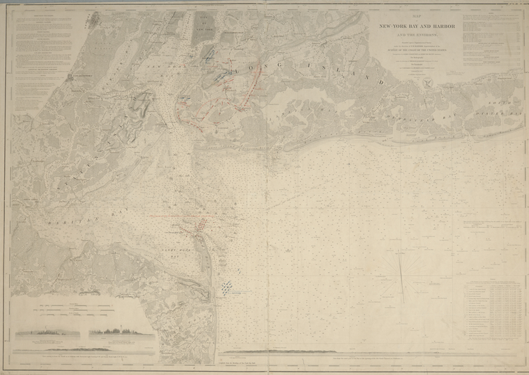
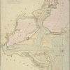
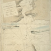
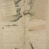
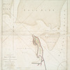
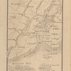
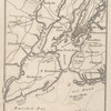
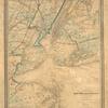
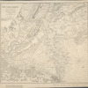
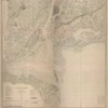
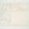
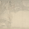
TitleMap of New-York Bay and Harbor and the environs : with colored manuscript additions to show positions of troops and fleets at the Battle of Long Island, 1776
NamesFarley, John, 1802 or 1803-1874 (Associated name)Gedney, Thomas R. (Associated name)Humphreys, A. A. (Andrew Atkinson), 1810-1883 (Associated name)United States Coast Survey (Publisher)Lawson, Oscar A., 1813-1854 (Associated name)Mathiot, G. (Associated name)Blunt, Edmund M. (Edmund March), 1770-1862 (Associated name)Rollé, A. (Associated name)Ferguson, James, 1710-1776 (Associated name)Hassler, F. R. (Ferdinand Rudolph), 1770-1843 (Surveyor)Jenkins, T. A. (Associated name)Renard, C. (Associated name)Bache, A. D. (Alexander Dallas), 1806-1867 (Associated name)Dankworth, Frederick, approximately 1804- (Associated name)Siebert, Selmar (Associated name)Knight, J. (Jonathan), 1787-1858 (Associated name)Sands, B. F. (Benjamin Franklin), 1811-1883 (Associated name)
CollectionMaps of New York City and State
New York City
New York Harbor
Dates / OriginDate Issued: 1845Place: [Washington, D.C.]Publisher: Survey of the Coast of the United States
Library locationsLionel Pincus and Princess Firyal Map DivisionShelf locator: Map Div. 01-1767 [Filed with N.Y.S. Rev. War. Long Island Battle of, 1776]
TopicsNew York (N.Y.)New JerseyLong Island, Battle of, New York, N.Y., 1776Harbors -- New York Metropolitan AreaNautical charts -- New York Harbor (N.Y. and N.J.)Nautical charts -- New York Metropolitan AreaNew York (N.Y.) -- History -- Revolution, 1775-1783 -- Maps
GenresMaps
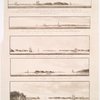
NotesContent: "Topography engraved by S. Siebert & A. Rolle; views engraved by O.A. Lawson ; engraving supervised & views of the coast drawn by J. Farley ; hydrography engraved by F. Dankworth ; lettering by F. Dankworth & J. Knight."Content: Annotated with red and blue ink to show positions of troops and fleets at the Battle of Long Island. NNContent: In upper right margin: Electrotype copy no. 7, by G. Mathiot U.S.C.S.Content: National Endowment for the Humanities Grant for Access to Early Maps of the Middle Atlantic Seaboard.Content: Prime meridians: New York and Greenwich.Content: Relief shown by hachures; depths shown by soundings.Content: Includes text, table of currents, and 4 coastal panoramas.Statement of responsibility: founded upon a trigonometrical survey under the direction of F.R. Hassler, superintendent of the Survey of the Coast of the United States ; triangulation by James Ferguson and Edmund Blunt, assistants ; the hydrography under the direction of Thomas R. Gedney, lieutenant U.S. Navy ; the topography by C. Renard, T.A. Jenkins & B.F. Sands assists. ; A.D. Bache superintendent ; verified by Lieut. A.A. Humphreys, topl. engrs. assistant, U.S. Coast Survey.
Physical DescriptionExtent: 1 map ; 61 x 88 cm.
Type of ResourceCartographic
IdentifiersRLIN/OCLC: 45848513NYPL catalog ID (B-number): b14968547Universal Unique Identifier (UUID): 063a2480-c5ab-012f-719b-58d385a7bc34
Rights StatementThe New York Public Library believes that this item is in the public domain under the laws of the United States, but did not make a determination as to its copyright status under the copyright laws of other countries. This item may not be in the public domain under the laws of other countries. Though not required, if you want to credit us as the source, please use the following statement, "From The New York Public Library," and provide a link back to the item on our Digital Collections site. Doing so helps us track how our collection is used and helps justify freely releasing even more content in the future.
Item timeline of events
-
-
-
-
-
-