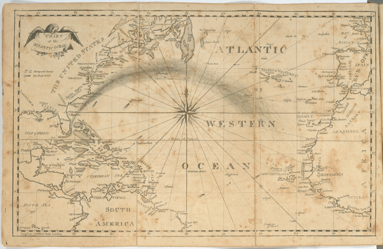
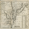
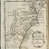
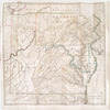
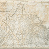
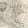
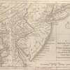
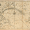
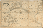
TitleChart of the Atlantic Ocean.
NamesBowditch, Nathaniel, 1773-1838 (Cartographer)
CollectionLawrence H. Slaughter Collection of English maps, charts, globes, books and atlases
Atlases
The new American practical navigator; : being an epitome of navigation; containing all the tables necessary to be used with the Nautical Almanac, in determining the latitude; and the longitude by lunar observations; and keeping a complete reckoning at sea. ... : The whole exemplified in a journal, kept from Boston to Madeira, in which all the rules of navigation are introduced ... : To which are added, some general instructions and information ... relative to maritime laws and mercantile customs. From the best authorities. ; enriched with a number of new tables, with original improvements and additions, and a large variety of new and important matter: also many thousand errors are corrected, which have appeared in the best systems of navigation yet published.
Dates / OriginDate Issued: 1802Place: [Newburyport, Mass.]Publisher: Printed ... by Edmund M. Blunt (Proprietor) for Cushing & Appleton, Salem : Sold by every book-seller, ship-chandler, and mathematical-instrument-maker in the United States and West-Indies,
Library locationsLionel Pincus and Princess Firyal Map DivisionShelf locator: Map Div. 97-6461[LHS 4002, atlas cases]Shelf locator: Map Div. 97-6461 (Map preceding t.p.) [In LHS 4002]
TopicsNautical astronomyNavigationAtlantic OceanAtlantic Ocean -- MapsNorth Atlantic Ocean -- Maps
GenresMaps
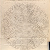
NotesContent: Lawrence H. Slaughter Collection ; 4002.Content: National Endowment for the Humanities Grant for Access to Early Maps of the Middle Atlantic Seaboard.Content: In 4 corners of map, from lower right, counterclockwise: A -- B -- C -- D.Content: Lawrence H. Slaughter Collection.Content: Prime meridian: London.Content: Shows currents and trade winds.
Physical DescriptionExtent: 1 map ; 20 x 32 cm. folded to 22 x 15 cm.
Type of ResourceCartographic
IdentifiersRLIN/OCLC: 40409296NYPL catalog ID (B-number): b15346336RLIN/OCLC: 49052838NYPL catalog ID (B-number): b15346338Universal Unique Identifier (UUID): c8ad2fa0-c5d4-012f-6733-58d385a7bc34
Rights StatementThe New York Public Library believes that this item is in the public domain under the laws of the United States, but did not make a determination as to its copyright status under the copyright laws of other countries. This item may not be in the public domain under the laws of other countries. Though not required, if you want to credit us as the source, please use the following statement, "From The New York Public Library," and provide a link back to the item on our Digital Collections site. Doing so helps us track how our collection is used and helps justify freely releasing even more content in the future.
Item timeline of events
-
-
-
-
-
-