


- The Library Shop
- Privacy Policy
- Rules and Regulations
- Using the Internet
- Website Terms and Conditions
- Gifts of Materials to NYPL
-
© The New York Public Library, 2024
The New York Public Library is a 501(c)(3) | EIN 13-1887440
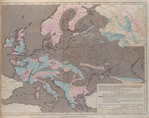
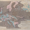
General Research Division, The New York Public Library. "Map shewing the extent of surface in Europe which has been covered by water since the commencement of the deposition of the older Tertiary strata." The New York Public Library Digital Collections. 1830 - 1833. https://digitalcollections.nypl.org/items/510d47dc-9f7d-a3d9-e040-e00a18064a99
General Research Division, The New York Public Library. "Map shewing the extent of surface in Europe which has been covered by water since the commencement of the deposition of the older Tertiary strata." New York Public Library Digital Collections. Accessed April 27, 2024. https://digitalcollections.nypl.org/items/510d47dc-9f7d-a3d9-e040-e00a18064a99
General Research Division, The New York Public Library. (1830 - 1833). Map shewing the extent of surface in Europe which has been covered by water since the commencement of the deposition of the older Tertiary strata. Retrieved from https://digitalcollections.nypl.org/items/510d47dc-9f7d-a3d9-e040-e00a18064a99
<ref name=NYPL>{{cite web | url=https://digitalcollections.nypl.org/items/510d47dc-9f7d-a3d9-e040-e00a18064a99 | title=
(cartographic)
Map shewing the extent of surface in Europe which has been covered by water since the commencement of the deposition of the older Tertiary strata., (1830 - 1833)
|author=Digital Collections, The New York Public Library |accessdate=April 27, 2024 |publisher=The New York Public Library, Astor, Lenox, and Tilden Foundations}}</ref>