


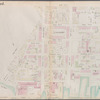
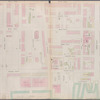
![Plate 1: [Bounded by Montgomery Street, New York Avenue, Malbone Street, Kingston Avenue, Fenimore Street, Ocean Avenue and Flatbush Avenue.]](https://images.nypl.org/index.php?id=1519717&t=b)
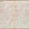
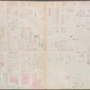
![Plate 2: [Bounded by Fenimore Street, Kingston Avenue, Winthrop Street, E. 39th Street, Linden Avenue, E. 40th Street, Grant Street, Flatbush Avenue, Church Lane, Ocean Avenue, Franklin Avenue and E. 21st Street.]](https://images.nypl.org/index.php?id=1519718&t=b)
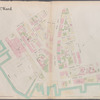
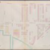
![Plate 3: [Bounded by Grant Street, Clove Drive (Cemetery of the Holy Cross), Canarsie Lane, E. 40th Street, Avenue D, Rogers Street, Newkirk Avenue, Ocean Avenue, Avenue A and Flatbush Avenue.]](https://images.nypl.org/index.php?id=1519719&t=b)
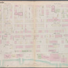
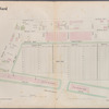
![Plate 4:[Bounded by Terrace Place, Coney Island Avenue (Prospect Park), Ocean (Franklin Avenue) Parkway, Ocean Avenue, Avenue A, West Street, Fort Hamilton Avenue and Gravesend Avenue.]](https://images.nypl.org/index.php?id=1519720&t=b)
![Plate 5: [Bounded by Avenue A, Ocean Avenue, Avenue E, E. 13th Street, Avenue D, Coney Island Avenue, Avenue E, West Street and Church Lane.]](https://images.nypl.org/index.php?id=1519721&t=b)
![Plate 6: [Bounded by Avenue E, Coney Island Avenue, Franklin Avenue, E. 16th Street, Newkirk Avenue, Ocean Avenue, Avenue I and West Street.]](https://images.nypl.org/index.php?id=1519722&t=b)
![Plate 7: [Bounded by 60th Street, Seventh Avenue, 66th Street, Stewart Avenue, 75th Street, Fourth Avenue, 72nd Street, Second Avenue, 71st Street, First Avenue, Mackay Place, Shore Road and New York Bay Pier Line.]](https://images.nypl.org/index.php?id=1519723&t=b)
![Plate 8: [Bounded by Mackay Place, Narrows Avenue, 71st Street, First Avenue, 72nd Street, Second Avenue, 73rd Street, Third Avenue, 74th Street, Fourth Avenue, 75th Street, Stewart Avenue, 89th Street, Third Avenue, 87th Street, First Avenue, 86th Street, Narrows Avenue, 85th Street and Shore Road.]](https://images.nypl.org/index.php?id=1519724&t=b)
![Plate 9: [Bounded by 85th Street, Narrows Avenue, 86th Street, Second Avenue, 87th Street, Fifth Avenue, 86th Street, Bay 2nd Street, Bath Avenue, Bay Street (Dyker Basin), Sharp Avenue, Bay 2nd Street, 112th Street, Seventh Avenue, 113th Street, (United States Government) Battery Avenue and (Narrows) Shore Road.]](https://images.nypl.org/index.php?id=1519725&t=b)
![Plate 10: [Bounded by 72nd Street, Fourteenth Avenue, 86th Street and Stewart Avenue.]](https://images.nypl.org/index.php?id=1519726&t=b)
![Plate 11: [Bounded by 58th Street, Fourteenth Avenue, 72nd Street, Stewart Avenue Cowenhoven Lane and Seventh Avenue.]](https://images.nypl.org/index.php?id=1519727&t=b)
![Plate 12: [Bounded by 4rd Street, Fourteenth Avenue, 58th Street, Eighth Avenue, 49th Street and Ninth Avenue.]](https://images.nypl.org/index.php?id=1519728&t=b)
![Plate 13: [Bounded by West Street, Sixteenth Avenue, 43rd Street, Ninth Avenue, 37th Street (Greenwood Cemetery) and Fort Hamilton Avenue.]](https://images.nypl.org/index.php?id=1519729&t=b)
- The Library Shop
- Privacy Policy
- Rules and Regulations
- Using the Internet
- Website Terms and Conditions
- Gifts of Materials to NYPL
-
© The New York Public Library, 2024
The New York Public Library is a 501(c)(3) | EIN 13-1887440
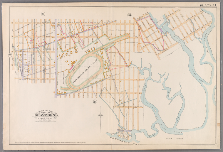
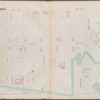
![Plate 27: [Bounded by Avenue U, Gerritsen Avenue, Avenue U, Marsh Street, Avenue V, E. 35th Street, Avenue W, Ryder Street, Avenue X, Gerritsen Avenue, Avenue W, Knapp Street, Avenue V, Bragg Street, Emmons Avenue, Ford Street, Voorhies Avenue, Batchelder Street, Avenue Z, Jerome Avenue, Ocean Avenue, Avenue Y and E. 12th Street.]](https://images.nypl.org/index.php?id=1519743&t=b)
Robinson's atlas of Kings County, New York : compiled from official records ... [1890]
Lionel Pincus and Princess Firyal Map Division, The New York Public Library. "Plate 27: [Bounded by Avenue U, Gerritsen Avenue, Avenue U, Marsh Street, Avenue V, E. 35th Street, Avenue W, Ryder Street, Avenue X, Gerritsen Avenue, Avenue W, Knapp Street, Avenue V, Bragg Street, Emmons Avenue, Ford Street, Voorhies Avenue, Batchelder Street, Avenue Z, Jerome Avenue, Ocean Avenue, Avenue Y and E. 12th Street.]" The New York Public Library Digital Collections. 1890. https://digitalcollections.nypl.org/items/510d47e2-49db-a3d9-e040-e00a18064a99
Lionel Pincus and Princess Firyal Map Division, The New York Public Library. "Plate 27: [Bounded by Avenue U, Gerritsen Avenue, Avenue U, Marsh Street, Avenue V, E. 35th Street, Avenue W, Ryder Street, Avenue X, Gerritsen Avenue, Avenue W, Knapp Street, Avenue V, Bragg Street, Emmons Avenue, Ford Street, Voorhies Avenue, Batchelder Street, Avenue Z, Jerome Avenue, Ocean Avenue, Avenue Y and E. 12th Street.]" New York Public Library Digital Collections. Accessed April 16, 2024. https://digitalcollections.nypl.org/items/510d47e2-49db-a3d9-e040-e00a18064a99
Lionel Pincus and Princess Firyal Map Division, The New York Public Library. (1890). Plate 27: [Bounded by Avenue U, Gerritsen Avenue, Avenue U, Marsh Street, Avenue V, E. 35th Street, Avenue W, Ryder Street, Avenue X, Gerritsen Avenue, Avenue W, Knapp Street, Avenue V, Bragg Street, Emmons Avenue, Ford Street, Voorhies Avenue, Batchelder Street, Avenue Z, Jerome Avenue, Ocean Avenue, Avenue Y and E. 12th Street.] Retrieved from https://digitalcollections.nypl.org/items/510d47e2-49db-a3d9-e040-e00a18064a99
<ref name=NYPL>{{cite web | url=https://digitalcollections.nypl.org/items/510d47e2-49db-a3d9-e040-e00a18064a99 | title=
(cartographic)
Plate 27: [Bounded by Avenue U, Gerritsen Avenue, Avenue U, Marsh Street, Avenue V, E. 35th Street, Avenue W, Ryder Street, Avenue X, Gerritsen Avenue, Avenue W, Knapp Street, Avenue V, Bragg Street, Emmons Avenue, Ford Street, Voorhies Avenue, Batchelder Street, Avenue Z, Jerome Avenue, Ocean Avenue, Avenue Y and E. 12th Street.], (1890)
|author=Digital Collections, The New York Public Library |accessdate=April 16, 2024 |publisher=The New York Public Library, Astor, Lenox, and Tilden Foundations}}</ref>
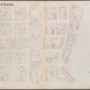
![Plate 27: [Bounded by Avenue U, Gerritsen Avenue, Avenue U, Marsh Street, Avenue V, E. 35th Street, Avenue W, Ryder Street, Avenue X, Gerritsen Avenue, Avenue W, Knapp Street, Avenue V, Bragg Street, Emmons Avenue, Ford Street, Voorhies Avenue, Batchelder Street, Avenue Z, Jerome Avenue, Ocean Avenue, Avenue Y and E. 12th Street.]](https://images.nypl.org/index.php?id=1519743&t=t)