


- The Library Shop
- Privacy Policy
- Rules and Regulations
- Using the Internet
- Website Terms and Conditions
- Gifts of Materials to NYPL
-
© The New York Public Library, 2024
The New York Public Library is a 501(c)(3) | EIN 13-1887440
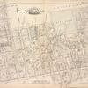
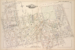
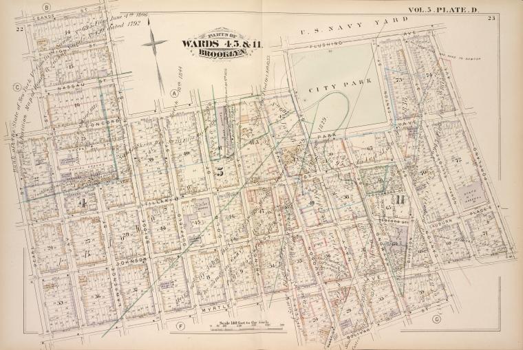
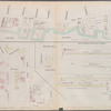
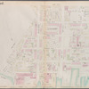
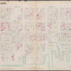
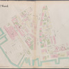
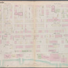
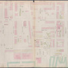
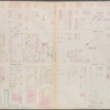
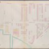
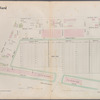
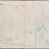
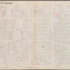
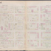
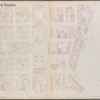
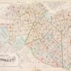
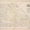
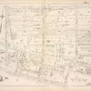
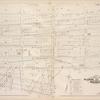
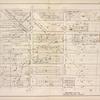
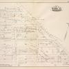
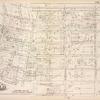
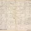
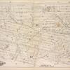
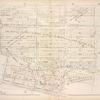
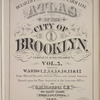
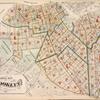
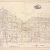
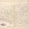
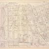
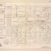
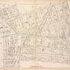
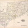
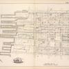
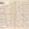
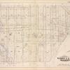
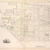
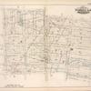
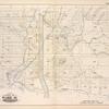
Lionel Pincus and Princess Firyal Map Division, The New York Public Library. "Map bound by Sands St., U.S. Navy Yard, Portland Ave., Myrtle Ave., Canton St., Bolivar St., Fleet Place, Pearl St., Concord St., Jay St.; Including High St., Nassau St., Flushing Ave., Chapel St., Park Ave., Tillary St., Sycamore St., Johnson St., Bedford St., Auburn Place, Lawrence St., Bridge St., Duffield St., Gold St., Prince St., Hudson Ave., Navy St., Raymond St., Division St., Elliott St." The New York Public Library Digital Collections. 1880. https://digitalcollections.nypl.org/items/510d47e4-4199-a3d9-e040-e00a18064a99
Lionel Pincus and Princess Firyal Map Division, The New York Public Library. "Map bound by Sands St., U.S. Navy Yard, Portland Ave., Myrtle Ave., Canton St., Bolivar St., Fleet Place, Pearl St., Concord St., Jay St.; Including High St., Nassau St., Flushing Ave., Chapel St., Park Ave., Tillary St., Sycamore St., Johnson St., Bedford St., Auburn Place, Lawrence St., Bridge St., Duffield St., Gold St., Prince St., Hudson Ave., Navy St., Raymond St., Division St., Elliott St." New York Public Library Digital Collections. Accessed April 18, 2024. https://digitalcollections.nypl.org/items/510d47e4-4199-a3d9-e040-e00a18064a99
Lionel Pincus and Princess Firyal Map Division, The New York Public Library. (1880). Map bound by Sands St., U.S. Navy Yard, Portland Ave., Myrtle Ave., Canton St., Bolivar St., Fleet Place, Pearl St., Concord St., Jay St.; Including High St., Nassau St., Flushing Ave., Chapel St., Park Ave., Tillary St., Sycamore St., Johnson St., Bedford St., Auburn Place, Lawrence St., Bridge St., Duffield St., Gold St., Prince St., Hudson Ave., Navy St., Raymond St., Division St., Elliott St. Retrieved from https://digitalcollections.nypl.org/items/510d47e4-4199-a3d9-e040-e00a18064a99
<ref name=NYPL>{{cite web | url=https://digitalcollections.nypl.org/items/510d47e4-4199-a3d9-e040-e00a18064a99 | title=
(cartographic)
Map bound by Sands St., U.S. Navy Yard, Portland Ave., Myrtle Ave., Canton St., Bolivar St., Fleet Place, Pearl St., Concord St., Jay St.; Including High St., Nassau St., Flushing Ave., Chapel St., Park Ave., Tillary St., Sycamore St., Johnson St., Bedford St., Auburn Place, Lawrence St., Bridge St., Duffield St., Gold St., Prince St., Hudson Ave., Navy St., Raymond St., Division St., Elliott St., (1880)
|author=Digital Collections, The New York Public Library |accessdate=April 18, 2024 |publisher=The New York Public Library, Astor, Lenox, and Tilden Foundations}}</ref>