


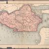

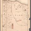
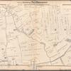
![Plate 1, Part of Ward 1 [Map bound by Richmond Terrace (Bay St), Pierhead Line, Hyatt St, St. Marks PL (Tompkins Ave), Fort PL, Daniel Low Terrace, Hamilton Ave, Nicholas St]](https://images.nypl.org/index.php?id=1646318&t=b)
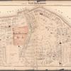
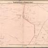
![Plate 2, Part of Ward 1 [Map bound by Fort PL, St. Marks PL (Tompkins Ave), Hyatt St, Borough PL (South St), Bulkhead Line, Arrietta St, Richmond Turnpike, Westervelt Ave (Oak St), Hendricks Ave (5th Ave), Sherman Ave]](https://images.nypl.org/index.php?id=1646319&t=b)
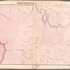
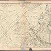
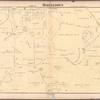
![Plate 3, Part of Ward 1 [Map bound by Brighton Ave, York Ave, Pauw St (Centre St), Jersey St, Taft Ave (6th Ave), Westervelt Ave (Oak St), Richmond Turnpike, Cebra Ave, Castleton Ave, Wester Ave]](https://images.nypl.org/index.php?id=1646320&t=b)
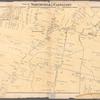
![Plate 4, Part of Ward 1 [Map bound by Pierhead Line, Richmond Terrace, Nicholas St, St. Marks PL, Hamilton Ave, Daniel Low Terrace, Fort PL, Taft Ave (6th Ave), Jersey St, Pauw St (Center), York Ave, Prospect Ave, La Fayette Ave]](https://images.nypl.org/index.php?id=1646321&t=b)
![Plate 5, Part of Ward 1 [Map bound by Greenwood Ave, Ridgewood PL, Castleton Ave, Brighton Ave, Third St, La Fayette Ave, Prospect Ave, York Ave, Webster Ave, Cebra Ave, Richmond Turnpike, Silver Lake Reservoir]](https://images.nypl.org/index.php?id=1646322&t=b)
![Plate 6, Part of Ward 2 [Map bound by Richmond Turnpike, Arriette St, Bulkhead Line, Bay St (Griffin St), Congress St, Van Duzer St (Richmond RD), Sands St, Wave St, Beach St, St. Pauls Ave, Occident Ave, Ward Ave, Austin PL (St)]](https://images.nypl.org/index.php?id=1646323&t=b)
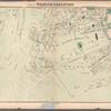
![Plate 7, Part of Ward 2 [Map bound by St. Pauls Ave, Beach St, Jackson St, Van Duzer St (Richmond RD), Sands St, Wave St, Front St, Thompson St, Bay St, Broad St, Gordon St, Purroy St (Elm), Targee St]](https://images.nypl.org/index.php?id=1646324&t=b)
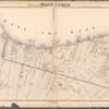
![Plate 8, Part of Ward 2 [Map bound by Broad St, Bay St, Thompson St, Front St, Dock St, Vanderbilt Ave, Pleasant PL, Coursen PL, Dix PL (Elm), Hill St, Fulton St, Meadow St, Patten St]](https://images.nypl.org/index.php?id=1646325&t=b)
![Plate 9, Part of Ward 2 [Map bound by Serpentine Road, Howard Ave (Serpentine RD) , Broad St, Gordon St, Tompkins St (Serpentine RD), Warren St, Pleasant PL, Vanderbilt Ave, Richmond Road, Northcole Ave, Cedar Terrace]](https://images.nypl.org/index.php?id=1646326&t=b)
![Plate 10, Part of Ward 2 [Map bound by Richmond Turnpike, Austin PL, Occident Ave, St. Pauls Ave, Stone St, Targee St, Purroy St (Elm St), Gordon St, Broad St, Howard Ave (Serpentine RD), Eddy St, Duncan Ave, Thressea PL]](https://images.nypl.org/index.php?id=1646311&t=b)
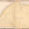
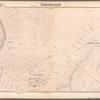
![Plate 11, Part of Ward 1 [Map bound by Bement Ave, Harvest Ave, Revere Ave (Laurel Ave), University PL, Greenwood Ave, Forest Ave (Barrett Blvd), Reservoir North Basin, Richmond Turnpike, Clove Road]](https://images.nypl.org/index.php?id=1646312&t=b)
![Plate 12, Part of Ward 1 [Map bound by Castleton Ave, Forest Ave (Brighton), Greenwood Ave, University PL, Revere Ave (Laurel Ave), Laurel Ave, Bard Ave, Lawrence Ave (Pelton Ave), Davis Ave, Pelton Ave (Lowell Ave), Shaw Ave, Bement Ave, Cary Ave]](https://images.nypl.org/index.php?id=1646313&t=b)
- The Library Shop
- Privacy Policy
- Rules and Regulations
- Using the Internet
- Website Terms and Conditions
- Gifts of Materials to NYPL
-
© The New York Public Library, 2024
The New York Public Library is a 501(c)(3) | EIN 13-1887440
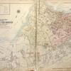
![Atlas of The City of New York - Borough of Richmond Staten Island Volume One Wards 1, 2, & 3 [Title Page]](https://images.nypl.org/index.php?id=1646315&t=b)
Lionel Pincus and Princess Firyal Map Division, The New York Public Library. "Atlas of The City of New York - Borough of Richmond Staten Island Volume One Wards 1, 2, & 3 [Title Page]" The New York Public Library Digital Collections. 1917. https://digitalcollections.nypl.org/items/5e66b3e8-df4a-d471-e040-e00a180654d7
Lionel Pincus and Princess Firyal Map Division, The New York Public Library. "Atlas of The City of New York - Borough of Richmond Staten Island Volume One Wards 1, 2, & 3 [Title Page]" New York Public Library Digital Collections. Accessed April 25, 2024. https://digitalcollections.nypl.org/items/5e66b3e8-df4a-d471-e040-e00a180654d7
Lionel Pincus and Princess Firyal Map Division, The New York Public Library. (1917). Atlas of The City of New York - Borough of Richmond Staten Island Volume One Wards 1, 2, & 3 [Title Page] Retrieved from https://digitalcollections.nypl.org/items/5e66b3e8-df4a-d471-e040-e00a180654d7
<ref name=NYPL>{{cite web | url=https://digitalcollections.nypl.org/items/5e66b3e8-df4a-d471-e040-e00a180654d7 | title=
(cartographic)
Atlas of The City of New York - Borough of Richmond Staten Island Volume One Wards 1, 2, & 3 [Title Page], (1917)
|author=Digital Collections, The New York Public Library |accessdate=April 25, 2024 |publisher=The New York Public Library, Astor, Lenox, and Tilden Foundations}}</ref>
![Atlas of The City of New York - Borough of Richmond Staten Island Volume One Wards 1, 2, & 3 [Title Page]](https://images.nypl.org/index.php?id=1646315&t=t)