


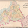
![Plate 4: [Bounded by Pomeroy Street, Jackson Avenue, Nott Avenue, Creek Street, Borden Avenue, West Avenue, Flushing Street, Front Street, Fifth Street, West Avenue, Nott Avenue, Vernon Avenue, Sanford Street, Sherman Street, Pierce Avenue, Lockwood Avenue and Webster Avenue.]](https://images.nypl.org/index.php?id=1523074&t=b)
![Plate 5: [Bounded by Dickinson Street, Woodside Avenue, Calvary Cemetery Road, Borden Avenue, Greenpoint Avenue, (Calvary Cemetery) Bradley Avenue, Review Avenue, Bradley Avenue, Orton Street, Nott Avenue and Jackson Avenue.]](https://images.nypl.org/index.php?id=1523075&t=b)
![Plate 6: [Bounded by Franklin Street, Flushing Avenue, Old Bowery Bay Blvd., Jackson Avenue, Western Avenue, Lockwood Avenue, Pierce Avenue, Sherman Street, Broadway, Boulevard, Fulton Street and Mills Street.]](https://images.nypl.org/index.php?id=1523076&t=b)
![Plate 7: [Bounded by Berrians Avenue, De Bevoise Avenue, Riker Avenue, Old Bowery Road, Cabinet Street, Flushing Avenue, Mills Street, Orchard Street, Remsen Street and Boulevard.]](https://images.nypl.org/index.php?id=1523077&t=b)
![Plate 8: [Bounded by Hillside Ave., Union Ave., Highland Ave., Grand St., Warwick Ave., Warwick Crescent, King St., Madison St., Fulton St., Wheeleer Ave., South St., George St., Sayres St., Merrick & Jamaica Plank Rd., South St., Jay St., Humboldt Blvd., Wyckoff Street, Liberty Ave., Guilford St., Chichester Ave., Kensington Ave., Johnston Ave., Rockway Tpke., Fulton St. & Hoffman Blvd.]](https://images.nypl.org/index.php?id=1523078&t=b)
![Plate 9: [Bounded by Lawrence Avenue, Bayside Avenue, Congress Avenue, Myrtle Avenue, Whitestone Avenue, Bayside Avenue, Murray Avenue, Sanford Avenue, Parsons Avenue, Laburnum Avneue, Bowne Avenue, Oak Avenue, Jamaica Avenue, Mulberry Street, Colden Avenue, Franklin Pl., Summit Street, Bank Street.]](https://images.nypl.org/index.php?id=1523079&t=b)
![Plate 10: [Bounded by Intersection Street, Franklin Street, Stevens Avenue, Main Street, Columbia Street, Stewart Avenue, Bennett Avenue, Fulton Street, William Street, Gerard Street, Greenwich Street, Grove Street, Prospect Street, Franklin Street, Front Street, Fulton Street, Cathedral Avenue, Atlantic Street and Cedar Valley Street.]](https://images.nypl.org/index.php?id=1523080&t=b)
![Plate 11: [Bounded by Bay Avenue, Franklin Avenue, Ocean Avenue, Healey Avenue, Bayview Avenue, The Strand, Bay Street, Mott Avenue, Grand Avenue, Crescent Place, Bay Street, Mott Avenue, Bay view Terrace, Cedar Avenue, Mott Avenue, Central Avenue, John Street, Wave Crest Avenue, and Bay Avenue.]](https://images.nypl.org/index.php?id=1523081&t=b)
![Plate 12: [Bounded by Central Avenue, Boulevard, Horton Avenue, Remsen Avenue, Mc Neil Avenue, Central Avenue, Lord Avenue, Greenwood, Jarvis Avenue, Cedar Hill Avenue, Fenwick Avenue, Somerset Avenue, Cedar Hill Avenue, Oak Street, Greenwood, Rue De. St. Felix, Coster Street and South Street.]](https://images.nypl.org/index.php?id=1523082&t=b)
![Plate 13: [Bounded by Rockaway Beach Boulevard, Averne Boulevard,... (Atlantic Ocean, Jamaica Bay), Eldert Avenue, Rockaway Beach Boulevard, Eastern Avenue, Triton Avenue and Tenth Avenue.]](https://images.nypl.org/index.php?id=1523083&t=b)
![Street Index for Fourth Ward. [Front]](https://images.nypl.org/index.php?id=1693890&t=b)
![Street Index for Fifth Ward. [Front]](https://images.nypl.org/index.php?id=1693891&t=b)
![Queens, Vol. 1, Double Page Plate No. 1; Part of ward Four, Jamaica; [Map bounded by Borough of Brooklyn, Forest Park, Lott Ave., Vanerveer Ave., Leggett Ave., Road to Forest Park, Hill Side Ave., Benedic Ave., Dennington Ave., Ocean View Ave., Woodland Ave., Columbia Ave., Manor Ave., Willard Ave., Brooklyn and Jamaica Plank Road, Woodheaven Ave., Flushing Ave., Morris Ave., Atlantic Ave., Ridgewood Ave., Shaw Ave., Snedeker Ave., Johnson Ave., Center Ave., Drew Ave., Elderts Lane, Rockaway Plank Road, Fulton Ave.; Including Simpson St., Stanley St., Shipley St., Windom St., Howard St., Ashland St., Casco Ave., Ferriss St., Ferry St., Brandon St., Elmwood St., Elm St., Russel St., Forman St., Sterling St., Sliydam St., 1st St., 2nd St., 3rd St., 4th St., 5th St., 6th St., 7th St., 8th St., Lewis St., Grand St., John St.; Including Summit PL., Charles PL., Ruth PL., Emma PL., Roswell PL., Ditmas PL., Avondale PL., Pakland PL., Vanderveer PL., W PL>gt;gt;, I PL., Haven PL., Thrall PL., Agate PL., Crystal PL., Park PL., Melville PL., Graves PL., Clinton PL., Ptkin Pl.]](https://images.nypl.org/index.php?id=1693886&t=b)
![Queens, Vol. 1, Double Page Plate No. 2; Part of Ward Four, Jamaica; [Map bounded by Borough of Brooklyn, Elderst Lane, Drew Ave., Center Ave., Snedeker Ave., Rockaway Plank Road, Dakota Ave., Shaw Ave., Nevada Ave., Montana Ave., Fulton Ave., Benedict Ave., Morris Ave., Atlantic Ave., Flushing Ave., Hopkinton Ave., Walker Ave., Belmont Ave., Woodhaven Ave., Bigelow Ave., Thrall Ave., Cherardi Ave., Canal Ave., Kimball Ave., Broadway, Grafton Ave., Beaufort Ave., Chichester Ave., Belmont Ave., Pitkin Ave., Glenmore Ave., Old South Road; Including South St., 8th St., 3rd St., 4th St., Ferry St., Canal St., S. 3rd St., S. 2nd St., Weymouth St., Halifax St., Spruce St., Digby St., West St., Shoew and Leather St., Water St., Bengal St., Togo St., Fundy St., Emerald St., Ruby St., Fundy St.; Including Pitkin PL., Park PL., Clinton PL., Bigelow PL., Thrall PL., Lutheran PL., Oyama PL.]](https://images.nypl.org/index.php?id=1693887&t=b)
![Queens, Vol. 1, Double Page Plate No. 3; Part of Ward Four, Jamaica; [Map bounded by Atlantic Ave., Napier Ave., Ocean Ave., Hopkinton Ave., Woodhaven Ave., Flushing Ave., Grafton Ave., Hatch Ave., Shattuck Ave., Oakley Ave., Lawn Ave., Union Ave., Mc. Cormick Ave., Wyckoff Ave., Clinton Ave., Washington Ave., Hoffman Ave., Grant Ave., Myrtle Ave., Greenwood Ave., Grove Ave., Cedar Ave., Linden Ave., Hamilton Ave., Jefferson Ave., Broadway, Belmont Ave., Liberty Ave., Rockway Plank Road, Chester Ave., Vanwicklen Ave., Metropolis Ave., Stoothoff Ave.; Including South St., Concord St., Elm St., Oak St., Walnut St.; Including Vanderveer PL., University PL., Welcome PL.]](https://images.nypl.org/index.php?id=1693888&t=b)
![Queens, Vol. 1, Double Page Plate No. 4; Part of ward 4, Jamaica; [Map bounded by Manor Ave., Willard Ave., Magnolia Ave., Park Ave., Prospect Ave., Waterbury Ave., Garfiled Ave., Grant Ave., Cleveland Ave., Orchard Ave., Lincoln Ave., Washington Ave., Division Ave., Myrtle Ave., Central Ave., Brooklyn and Jamaica Plank Road, Napier Ave., Ridgewood Ave., Diamond Ave., Greenwood Ave., Grove Ave., Maple Ave., Stoothoff Ave., Hamilton Ave., Jefferson Ave., Stewart Ave., Briggs Ave., Fulton Ave., Atlantic Ave.; Including Ashland St., Avondale St., Ferris St., Elmwood St., Branson St., Tulip St., Walnut St., Chestnut St., Amber St., Oak St., Welling St., Cherry St., Maple St., Elm St., Walnut St., Park St., Market St., FultonSt., Popular St., Linden St., Beech St., North St., Lexington St., Pierce St., Scott St.; Including Union PL., Vanderveer PL., Guion PL., Napier PL., Pitkin PL.]](https://images.nypl.org/index.php?id=1693847&t=b)
![Queens, Vol. 1, Double Page Plate No. 5; Sub Plan; [Map bounded by Division Ave.; Including Market St., Church St., Richmond Hill St., Drive, Walnut St.];Part of ward 4, Jamaica; [Map bounded by Newtown Road, Whitepot Road, Cottage Ave., Richmond Ave., Williamsburgh Turnpike, Metropolitan Ave., Washington Ave., Morris Ave., Curtis Ave., Brooklyn and Jamaciam Plank Road, Central Ave., Lefferts Ave., Hillside Ave., Division Ave., Johnson Ave., Myrtle Ave., Briggs Ave., Stewart Ave., Fulton Ave., Grant Ave., Atlantic Ave.; Including Troy St., Greene St., Gould St., Wickes St., Sherman St., Ward St., Linden St., Arbor St., Vine St., Willow St., Spruce St., Beech St., Church St., Market St., Richmond St., Park St., Chestnut St., Monroe St., Linwood St.; Including Elm PL., Willow PL., Sycamore PL.]](https://images.nypl.org/index.php?id=1693848&t=b)
![Queens, Vol. 1, Double Page Plate No. 6; Part of Ward 4, Jamaica; [Map bounded by Atlantic Ave., Jefferson Ave., Briggs Ave., Johnson Ave., Lefferts Ave., Chichester Ave., Broadway, Belmont Ave., Liberty Ave., Morris Ave., Maure Ave., Frost Ave., Atfield Ave., Hulst Ave., Baker Ave., Vanwyck Ave., Dakota Ave., Minnesota Ave., Wyoming Ave. Nebraska Ave., Van Sicklen Ave., Dark Lane, Metropolis Ave.; Including Beech St., Walnut St., Church St., Brown St., Lambert St., Windsor St., Curtis St., Spruce St., Vine St., Beaufort St. Garden St., Sherman St., Wickes St., Mill St.; Including Blanco PL., Elm PL., Maple PL., Linden PL., Poplar PL.]](https://images.nypl.org/index.php?id=1693849&t=b)
![Queens, Vol. 1, Double Page Plate No. 7; Part of Ward 4, Jamaica; [Map bounded by Rockaway Turnpike, Vanderbilt Ave., Foley Ave., Campion Ave., Rose Ave., Mc.Auley Ave., Van Wyck Ave., Lester Ave., Agnolia Ave., Johnson Ave., Chichester Ave., Atlantic Ave., Beaufort Ave., Broadway, Whittier Ave., Bryant Ave., Lowell Ave., Longfellow Ave., Remington Ave., Liberty Ave., Wells Ave., Bandman Ave., Humboldt Blvd., Sylvester Ave., Shore Ave., Lincoln Ave.; Including Fulton St., Alsop St., Tyndall St., Guilford St., Clinton St., Carll St., Archer St., Jefferson St., Beaufort St., Elm St., Jay St., Henry St., Wyckoff St., Dean St., Baltic St., Allen St., West St., Swale Road, South St., 1st St., 2nd St.; Including Kissam PL., Archer PL., Hanson PL., Clifton PL., Bath PL., Irving PL., Napier PL., Blanco PL., Otto PL., Lux PL.]](https://images.nypl.org/index.php?id=1693850&t=b)
![Queens, Vol. 1, Double Page Plate No. 8; Part of Ward 4, Jamaica; [Map bounded by Kaplan Ave., Pette Ave., Jeffrey Ave., Hutton Ave., Maple Ave., Haffman Blvd., Sussman Ave., Jefferson Ave., Barrett Ave., Vanderbilt Ave., Keystone Ave., Oak Ave., Morningside Ave., Newtown Road, White Pot Road, Hillside Ave., Williamburgh Turnpike, Horton Ave., Hammond Ave., Shelton Ave., Brooklyn and Jamaica Turnpike, Muller Ave., Augustina Ave., Lefferts Ave., Hoffman Ave.; Including Welton St., Walton St., Williams St., Pierson St., Mitchell St., Rowland St., Lewis St., Hancock St., Troy St., Cottage St., Fulton St.]](https://images.nypl.org/index.php?id=1693851&t=b)
![Queens, Vol. 1, Double Page Plate No. 9; Sub Plan;[Map bounded by Flushing Ave., Grand Ave., Briarwood Road; Including Alsop St., Lake St., Orchard St., Hutton PL.]; Part of Ward 4, Jamaica; [Map bounded by Terrace Ave., Ocean View Ave., Kaplan Ave., De Grau Ave., Amherst Ave., Hillside Ave., Colonial Ave., Judd Ave., Shelton Ave., Carlton Ave., Flushing Ave., Lathrop Ave., Chapin Ave., Ayling Ave., Maxwell Ave., Desmond Ave., Malden Ave., Melrose Ave., Union Park Ave., Dix Ave., Highland Ave., Clinton Ave., Park Ave., Hillcrest Ave., Bergen Ave., Hardenbrook Ave., Harriman Ave.; Including Victoria St., Clyde Ave., Alsop St., Lake St., Orchard St., Glen St., Grand St., N. Washington St., Grove St., Ray St., Fulton St.; Including Colfax PL., Delap PL., St. Charles PL.]](https://images.nypl.org/index.php?id=1693852&t=b)
![Queens, Vol. 1, Double Page Plate No. 10; Part of Ward 4, Jamaica; [Map bounded by New York Ave., Brooklyn Ave., Globe Ave., Rail Road Ave., Norris Ave., Brown Ave., Phraner Ave., Dubroff Ave., O' Donnell Ave., Russell Ave., Woodlawn Ave.; Including Fulton St., Canal St., Smith St., Puntine St., Locust St., Locust St., Linden St., Evergreen St., South St., Union Hall St., Centre St., Washington St., Fleet St., Prospect St., Beaver St., Church St., Division St., Rockaway Turnpike, Alsop St., Atlantic St., W. Catherine St., Catherine St., Water St., Hackett St., Scudder St., Cumberland St., Pacific St., Kosciusco St., Henry St., Little St., Remsen St.; Including Clayton PL., Twombly PL., Styler PL., Jack PL., Fleming PL., Strenski PL., Guinsburg PL., Duke PL., Claude PL., Brown PL.]](https://images.nypl.org/index.php?id=1693853&t=b)
![Queens, Vol. 1, Double Page Plate No. 11; Sub Plan; Formerly Town of Flushing 3rd Ward; [Map bounded by Grand Ave., Black Stump Road, Charlecote, Croydon Jamaica Estates Road, Edgerton Blvd., Doncaster Blvd., Henley Road, Midland Parkway, Radnor Road, Brdnor Road, Avon Road, Kent Road, Chevy Chase Road]; Part of Ward 4 Jamaica; [Map bounded by Hillside Ave., Prospect Ave., Home Lawn Ave., Harvard Ave., Yale Ave., Larremore Ave., Homer Lee Ave., Compton Terrace, Warwick Ave., Hilldale Ave., Avalon Ave., Ackroyd Ave., Dugan Ave., Thomas Ave., Shelton Ave., Wheeler Ave., Cooper Ave., Dunham Ave., Candage Ave., Brenton Ave.; Including Madison St., High St., Lafayette St., King St., Emma St., Henry St., Orchard St., N. First St., Liberty St., Fulton St., Skidmore St., Charles St., Dora St., Franklin St., Willow St., Douglas St., Larch St., South St., Theoadbe St., Sayre St., George St., Gilbert St., Samuel St., William St.; Including Covert PL., Islington PL., Hedges PL., St. Albans PL., Eastwood PL.; Including Merrick Road, Radnor Road, Croydon Road, Charlecote Cardiff Road, Henley Road, Dalny Road, Ridge, Circle, Wexford Terrace, Midland Parkway, Putney Road, Black Stump Road, Canonburg Road]; Sub Plan; [Map bounded by The Odore St., Adolph St., George St.]](https://images.nypl.org/index.php?id=1693854&t=b)
![Atlas of the borough of Queens city of New York Vol. 2, Long Island City first ward. [Title Page]](https://images.nypl.org/index.php?id=1693944&t=b)
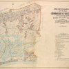
![Street Index for Long Island City (Ward One), Street Index for Newtown (Ward Two). [Front]](https://images.nypl.org/index.php?id=1693945&t=b)
![Queens, Vol. 2, Double Page Plate No. 1; Part of Long Island City Ward One (Part of Old Ward 1) Sub Plan; [Map bounded by Pier St., River St., Front St., Newtown Creek.]; Part of Long Island City Ward One (Part of Old Ward 1). [Map bounded by East River, West Ave., Vernon Ave., Jackson Ave., East Ave., Van Alst Ave., Ely Ave., Thomson Ave., Nott Ave., Borden Ave., Hunters Point Ave., Anable Ave., Duch Kill Creek, Newtown Creek; Including Division St., 10th St., 9th St., 8th St., 7th St., 6th St., 4th St., 3rd St., Flushing St., Pidgeon St., Front St., Court St., Pearson St., Davis St., Crane St., Beech St., Arch St., Meadow St., Oliver St., Hayward St., Creek St., Pennsylvania R. R.]](https://images.nypl.org/index.php?id=1693947&t=b)
![Queens, Vol. 2, Double Page Plate No. 2; Part of Long Island City Ward One (Part of Old Ward 1& 3). [Map bounded by Webster Ave., Freeman Ave., Vernon Ave., Payntar Ave., Beebe Ave., Wilbur Ave., Harris Ave., Jackson Ave., Nott Ave., West Ave., Ely Ave., Vanalst Ave., Boulevard, East Ave., West Ave.; Including Prospect St., Crescent St., William St., Sunswick St., Marion St., Sherman St., Hancock St., Hamilton St., Judson St., Noble St., Worth St., Harsell St., Babbett St., Rogers st., North Jane St., Charles St., Wallach St., Bodine St., Englis St., Fourteenth St., Thirteenth St., Twelfth St.. East River.]](https://images.nypl.org/index.php?id=1693948&t=b)
![Queens, Vol. 2, Double Page Plate No. 3; Part of Long Island City Ward One (Part of Old Ward 2, 3 & 4). [Map bounded by Washington Ave., Webster Ave., Freeman Ave., Rapelje Ave., Beebe Ave., Payntar Ave., Wilbur Ave., Hunter Ave., Jackson Ave., Thomson Ave., Nott Ave. Harris Ave., Skillman Ave. Queens Boulevard, Foster Ave.; Including Prospect st., Radde St., Academy St., Lockwood St., Lathrop St., Briell St., Bartow St., Blackwell St., Pomeroy St., North Jane St., South Jane St., Henry St., Barn St., Orchard St., Queens Pl., Dutch Kills Pl., Creek St., Van Pelt St., Hulst St., Buckley St., Honeywell St., Moore St., Rawson St., Hill St., Vandam St., School St., Mount St., Manley St., Orton St.]](https://images.nypl.org/index.php?id=1693949&t=b)
![Queens, Vol. 2, Double Page Plate No. 4; Part of Long Island City Ward One (Part of Old Wards 1 & 2 ) Sub Plan; [Map bounded by Water St., Marsh St., Proposed Canal]; Part of Long Island City Ward One (Part of Old Wards 1 & 2 ) [Map bounded by Nott Ave., Anable Ave., Hunters Point Ave., Borden Ave., Bradley Ave., Green Point Ave., Review Ave., Newtown Creek, Star Ave.; Including Vanpelt St., Hulst St., Honeywell St., Moore St., Rawson St., Hill St., Vandam St., Gale St., School St., Mount St., Manley St., Orton St., Pearsall St., Young St., Gilbert St., Beaver St., Marsh St., Water St., Howard St., Spring St., Preston St., Pine St., Van Mater St., Thomas St., Dufyea St.]](https://images.nypl.org/index.php?id=1693950&t=b)
![Queens, Vol. 2, Double Page Plate No. 5; Part of Long Island City Ward One (Part of Old Ward 2) and Part of Newtown Ward 2. [Map bounded by Middleburg Ave., Woodside Ave., Celtic (Highway to Calvary Cemetery) Ave., Bushwick and Newtown Turnpike, Borden Ave., Hunters Point Ave., Harold Ave., Covert Ave., Anable Ave., Nott Ave., Queens Boulevard, Foster Ave., Skillman Ave., Laurel Hill Ave., Barnett Ave.; Including Stone St., Fitting St., Heiser St., Gosman St., Carolin St., Bliss St., Grove St., Locust St., Madden St., Van Buren St., Lowery St., Bragaw St., Van Pelt St., Pennsylvania R.R.]](https://images.nypl.org/index.php?id=1693951&t=b)
![Queens, Vol. 2, Double Page No. 6; Part of Long Island City Ward One (Part of Old Ward 2 & 4) Sub Plan; [Map bounded by Harold Ave., Middleburg Ave.; Including Bragaw St., Lowery St., Van Buren St., Van Pelt St.]; Part of Long Island City Ward One (Part of Old Ward 2 & 4). [Map bounded by 4th Ave., Rapel Ave., 5th Ave., 6th Ave., 7th Ave., 8th Ave., 9th Ave., 10th Ave., Steinway Ave., 11th ave., 12th Ave., 13th Ave., 14th Ave., 15th Ave., 16th Ave., 17th Ave., 18th Ave., 19th Ave., Jamaica Ave., North Woodside, Newtown, Woodside Ave., Broadway, Graham Ave., Pierce Ave., Washington Ave., Jackson Ave., Harold Ave., Dreyer Ave., Pennsylvania R.R., Barnett Ave., Middleburg Ave., Laurel Hill Ave.; Including Briell St., Bartow St., Blackwell St., Pomeroy St., Kowenhoven St., Albert St., Winans St., Grace St., Stemler St., Luyster St., Titus St., Oakley St., Baldwins St., Cabinet St., Wallace St., Hobart St., Dickinson St., Stone St., Fitting St., Heiser St., Heiser St., Gosman St., Carolin St., Bliss St., Grove St., Locust St., Madden St., Van Buren St.]](https://images.nypl.org/index.php?id=1693952&t=b)
![Queens, Vol. 2, Double Page No. 7; Part of Long Island City Ward One (Part of Old Wards 3 & 4); [Map bounded by Webster Ave., Washington Ave., Pierce Ave., Graham Ave., Franklyn Ave., Vernon Ave., Broadway, Jamaica Ave., Rapelje Ave., 4th Ave., 3rd Ave., Debevoise Ave., 2nd Ave., 1st Ave., Vanalst Ave., Hopkins Ave., Ely Ave.; Including Lathrop St., Lockwood St., Academy St., Crescent St., Prospect St., Catherine St., William St., Spring St., Fulton St., Greenwich St., Henry St., Jay St., Front St., Sunswick St., Emerald St., Remsen St., Marion St., Radde St., Ridge St., Sherman St., Warren St., Hancock St., Hamilton St., Rutledge St., Camelia St., Lincoln St.]](https://images.nypl.org/index.php?id=1693953&t=b)
![Queens, Vol. 2, Double Page No. 8; Part of Long Island City Ward One (Part of Old Wards 4 & 5).; [Map bounded by Woolsey Ave., De Bevoise Ave., Ely Ave., Flushing Ave., Newtown Ave., Van Alst Ave., Hoyt Ave., Hopkins Ave., Grand Ave., Fulton Ave.; Including Bradford St., Carver St., Marc PL., Lockwood St., Lawrenoe St., Acadamy St., Isabella PL., Chauncey St., N. Henry St., Cooper St., Whitney St., Crescent St., Goodrigh St., Astor PL., Merchant St., Howland St., Hallett St., Spring St., Barclay St., Edward St., Willow St., Clark St., Taylor St., Remsen St., Sherman St., Woolsey St., Remsen St., Tisdale St., Wardell St., Baylies St., Stevens St., Perrot PL., Halsey St., Munson St., Mills St., First St., Welling St.]](https://images.nypl.org/index.php?id=1693958&t=b)
![Queens, Vol. 2, Double Page No. 9; Part of Long Island City Ward One (Part of Old Wards 4 & 5); [Map bounded by Debevoise Ave., Woolsey Ave., Flushing Ave., Grand Ave., Vandeventer Ave., Rapelje Ave., 4th Ave., 5th Ave., 6th Ave., 7th Ave., 8th Ave., 9th Ave., Steinway Ave., 10th Ave., 11th Ave., 12th Ave., 13th Ave., 14th Ave., 15th Ave., 16th Ave., 17th Ave., 18th Ave., 19th Ave., 20th Ave., Wilson Ave., Bowery Bay Road, Jamaica Ave., Hoyt Ave., Newtown Road; Including Lathrop St., Briell St., Bartow St., Blackwell St., Pomeroy St., Kouwenhoven St., Newtown St., Albert St., Theodore St., Winans St., Puroy St., Grace St., Stemler St., Luyster St., Grand St., Titus St., Oakley St., Baldwin St., Cabinet St., Wallace St., Hobart St.]](https://images.nypl.org/index.php?id=1693954&t=b)
![Queens, Vol. 2, Double Page No. 10; Part of Long Island City Ward One (Part of Old Ward 5); [Map bounded by Boulevard, Winthrop Ave., Wolcott Ave., Ditmars Ave., Potter Ave., Woolsey Ave., Flushing Ave., Nassau Ave., Frankfort Ave., Steinway Ave., 6th Ave., Rapelje Ave., Debevoise Ave., Van Alst Ave., Plaiet Ave.; Including Emily, Terrace, Edward St., Davidson St., Murison St., Philips St., Barclay St., Me Clellan PL., Bermel PL., Hallett St., Howland St., Crescent St., Merchant St., Goodrich St., Chauncey St., Lawrence St., Bartow St., Blackwell St., Pomeroy St., Kouwenhoven St., Albert St.]](https://images.nypl.org/index.php?id=1693955&t=b)
![Queens, Vol. 2, Double Page No. 11; Part of Long Island City Ward One (Part of Old Ward 5); [Map bounded by Winthrop Ave., Van Alst Ave., Debevoise Ave., Rapelje Ave.; Including Boulevard, Barclay St., Hallet St., Howland St., Crescent St., Merchant St., Goodrich St., Chauncey St., Lawrence St.]](https://images.nypl.org/index.php?id=1693956&t=b)
- The Library Shop
- Privacy Policy
- Rules and Regulations
- Using the Internet
- Website Terms and Conditions
- Gifts of Materials to NYPL
-
© The New York Public Library, 2024
The New York Public Library is a 501(c)(3) | EIN 13-1887440
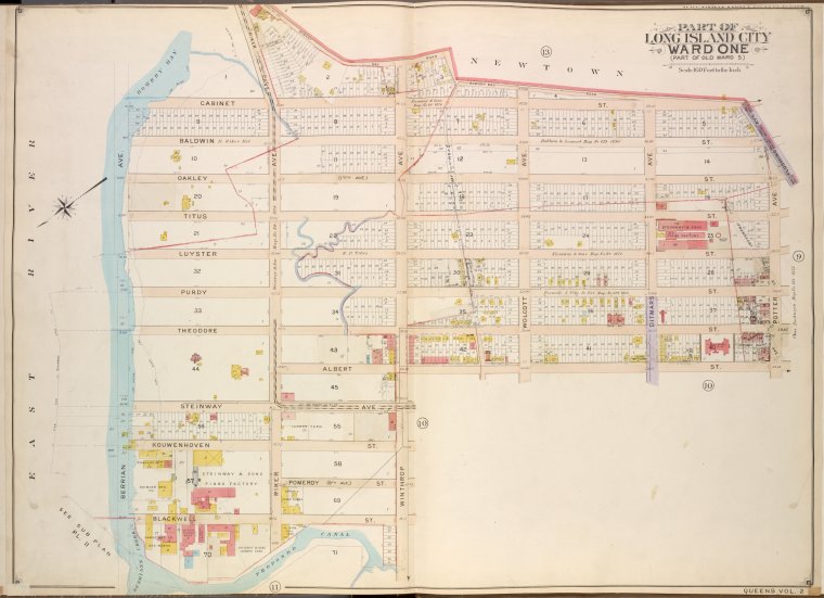
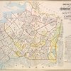
![Queens, Vol. 2, Double Page No. 12; Part of Long Island City Ward One (Part of Old Ward 5); [Map bounded by Berrian Ave., Riker Ave., Winthrop Ave., Wolcott Ave., Ditmars Ave., Potter Ave., Flushing Ave., Bremen Ave., Steinway Ave., 8th Ave.; Including Cabinet St., Balowin St., Oakley St., Titus St., Luyster St., Purdy St., Theodore St., Kouwenhoven St., Pomeroy St., Blackwell St., South St.]](https://images.nypl.org/index.php?id=1693957&t=b)
Lionel Pincus and Princess Firyal Map Division, The New York Public Library. "Queens, Vol. 2, Double Page No. 12; Part of Long Island City Ward One (Part of Old Ward 5); [Map bounded by Berrian Ave., Riker Ave., Winthrop Ave., Wolcott Ave., Ditmars Ave., Potter Ave., Flushing Ave., Bremen Ave., Steinway Ave., 8th Ave.; Including Cabinet St., Balowin St., Oakley St., Titus St., Luyster St., Purdy St., Theodore St., Kouwenhoven St., Pomeroy St., Blackwell St., South St.]" The New York Public Library Digital Collections. 1907 - 1908. https://digitalcollections.nypl.org/items/632461fe-bbb4-97e3-e040-e00a18063f5b
Lionel Pincus and Princess Firyal Map Division, The New York Public Library. "Queens, Vol. 2, Double Page No. 12; Part of Long Island City Ward One (Part of Old Ward 5); [Map bounded by Berrian Ave., Riker Ave., Winthrop Ave., Wolcott Ave., Ditmars Ave., Potter Ave., Flushing Ave., Bremen Ave., Steinway Ave., 8th Ave.; Including Cabinet St., Balowin St., Oakley St., Titus St., Luyster St., Purdy St., Theodore St., Kouwenhoven St., Pomeroy St., Blackwell St., South St.]" New York Public Library Digital Collections. Accessed April 23, 2024. https://digitalcollections.nypl.org/items/632461fe-bbb4-97e3-e040-e00a18063f5b
Lionel Pincus and Princess Firyal Map Division, The New York Public Library. (1907 - 1908). Queens, Vol. 2, Double Page No. 12; Part of Long Island City Ward One (Part of Old Ward 5); [Map bounded by Berrian Ave., Riker Ave., Winthrop Ave., Wolcott Ave., Ditmars Ave., Potter Ave., Flushing Ave., Bremen Ave., Steinway Ave., 8th Ave.; Including Cabinet St., Balowin St., Oakley St., Titus St., Luyster St., Purdy St., Theodore St., Kouwenhoven St., Pomeroy St., Blackwell St., South St.] Retrieved from https://digitalcollections.nypl.org/items/632461fe-bbb4-97e3-e040-e00a18063f5b
<ref name=NYPL>{{cite web | url=https://digitalcollections.nypl.org/items/632461fe-bbb4-97e3-e040-e00a18063f5b | title=
(cartographic)
Queens, Vol. 2, Double Page No. 12; Part of Long Island City Ward One (Part of Old Ward 5); [Map bounded by Berrian Ave., Riker Ave., Winthrop Ave., Wolcott Ave., Ditmars Ave., Potter Ave., Flushing Ave., Bremen Ave., Steinway Ave., 8th Ave.; Including Cabinet St., Balowin St., Oakley St., Titus St., Luyster St., Purdy St., Theodore St., Kouwenhoven St., Pomeroy St., Blackwell St., South St.], (1907 - 1908)
|author=Digital Collections, The New York Public Library |accessdate=April 23, 2024 |publisher=The New York Public Library, Astor, Lenox, and Tilden Foundations}}</ref>
![Queens, Vol. 2, Double Page No. 12; Part of Long Island City Ward One (Part of Old Ward 5); [Map bounded by Berrian Ave., Riker Ave., Winthrop Ave., Wolcott Ave., Ditmars Ave., Potter Ave., Flushing Ave., Bremen Ave., Steinway Ave., 8th Ave.; Including Cabinet St., Balowin St., Oakley St., Titus St., Luyster St., Purdy St., Theodore St., Kouwenhoven St., Pomeroy St., Blackwell St., South St.]](https://images.nypl.org/index.php?id=1693957&t=t)