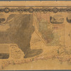
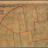
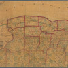
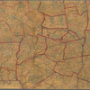
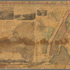
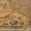
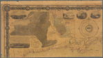
TitleThe State of New York: from new and original surveys
NamesFrench, J. H. (John Homer), 1824-1888 (Creator)Smith, Robert Pearsall, 1827-1898 (Publisher)
CollectionMaps of New York City and State
Whole
Dates / OriginDate Issued: 1860Place: No. 8 South Salina Street, SyracusePublisher: Robert Pearsall Smith
Library locationsLionel Pincus and Princess Firyal Map DivisionShelf locator: Map Div. 16-5768
TopicsGeology -- New York (State)Meteorology -- New York (State)New York (State)New York (N.Y.)
GenresMaps
NotesStatement of responsibility: under the direction of J.H. French, C.E.Content: Relief shown by hachures.Content: Prime meridians: Greenwich and Washington, D.C.Content: Includes: 13 lithographic views of prominent natural features, cities, and buildings throughout the state and statistical chart of religious denominations.Statement of responsibility: Complements J.H. French, Gazetteer of the State of New York (Syracuse: R.P. Smith, 1858-61).Content: Also includes: "Time dial showing the time at the several county seats when it is 12 òclock at the Dudley Observatory, Albany" [17 cm. dia.].Statement of responsibility: "Entered according to act of Congress, in the year 1859, by Robert Pearsall Smith, in the Clerk's Office of the District Court of the Northern District of New York."Content: Insets: Meteorological map of the state of New York / by Lorin Blodget -- Buffalo -- [City of] Rochester -- Comparative view of the capacities of churches of the religious denominations of New York -- Geological and land patent map of the state of New York -- City of Syracuse -- City of Oswego -- [New York City] -- City of Hudson -- City of Schenectady -- Poughkeepsie -- City of Albany -- Auburn City -- City of Troy -- Utica.Funding: Mapping the Nation (NEH grant, 2015-2018)
Physical DescriptionExtent: 1 map : hand colored ; 167 x 187 cm
Type of ResourceCartographic
IdentifiersRLIN/OCLC: 21868195 NYPL catalog ID (B-number): b20843163Other local Identifier: US144.2.01Universal Unique Identifier (UUID): 636fed70-a2ab-0133-adf0-00505686a51c
Rights StatementThe New York Public Library believes that this item is in the public domain under the laws of the United States, but did not make a determination as to its copyright status under the copyright laws of other countries. This item may not be in the public domain under the laws of other countries. Though not required, if you want to credit us as the source, please use the following statement, "From The New York Public Library," and provide a link back to the item on our Digital Collections site. Doing so helps us track how our collection is used and helps justify freely releasing even more content in the future.
Item timeline of events
-
-
-
-
-
-