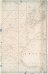
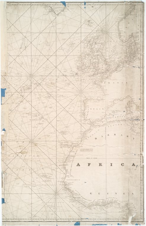
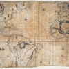
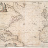
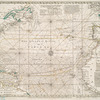
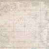
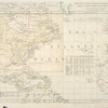
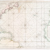
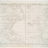
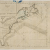
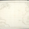
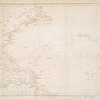
View this item elsewhere:

Title
A chart of the Atlantic or Western Ocean
Names
J. & C. Walker (Publisher)
Collection

Maps of the Oceans

Atlantic Ocean

Dates / Origin
Date Issued: 1830
Place: London
Publisher: Published ... by J. & A. Walker ...,
Library locations
Lionel Pincus and Princess Firyal Map Division
Shelf locator: Map Div. 01-5397
Topics
Atlantic Ocean
Nautical charts -- North Atlantic Ocean
North Atlantic Ocean -- Maps -- Early works to 1800
Genres
Maps
Notes
Content: Depths shown by soundings.
Content: Includes notes.
Content: National Endowment for the Humanities Grant for Access to Early Maps of the Middle Atlantic Seaboard.
Content: NYPL copy backed with blue paper and cloth; damaged in some places; year no longer visible.
Content: NYPL copy has ms. notations in pencil on face of map.
Content: Shows North Atlantic Ocean.
Citation/reference: NYPL. Dictionary Catalog of the Map Division, I, p. 476
Statement of responsibility: drawn from the latest surveys & astronomical observations by J. & A. Walker, London & Liverpool 1830.
Physical Description
Extent: 1 map on 2 sheets ; 90 x 118 cm., sheets 93 x 62 cm. 93 x 60 cm.
Type of Resource
Cartographic
Identifiers
RLIN/OCLC: 48759582
NYPL catalog ID (B-number): b15315216
Universal Unique Identifier (UUID): 6b5cacb0-c6bf-012f-dee2-58d385a7bc34
Rights Statement
The New York Public Library believes that this item is in the public domain under the laws of the United States, but did not make a determination as to its copyright status under the copyright laws of other countries. This item may not be in the public domain under the laws of other countries. Though not required, if you want to credit us as the source, please use the following statement, "From The New York Public Library," and provide a link back to the item on our Digital Collections site. Doing so helps us track how our collection is used and helps justify freely releasing even more content in the future.

Item timeline of events

  • 1830: Issued
  • 2013: Digitized
  • 2024: Found by you!
  • 2025

MLA Format

Lionel Pincus and Princess Firyal Map Division, The New York Public Library. "A chart of the Atlantic or Western Ocean" The New York Public Library Digital Collections. 1830. https://digitalcollections.nypl.org/items/8b726645-1787-9922-e040-e00a180644dd

Chicago/Turabian Format

Lionel Pincus and Princess Firyal Map Division, The New York Public Library. "A chart of the Atlantic or Western Ocean" New York Public Library Digital Collections. Accessed April 23, 2024. https://digitalcollections.nypl.org/items/8b726645-1787-9922-e040-e00a180644dd

APA Format

Lionel Pincus and Princess Firyal Map Division, The New York Public Library. (1830). A chart of the Atlantic or Western Ocean Retrieved from https://digitalcollections.nypl.org/items/8b726645-1787-9922-e040-e00a180644dd

Wikipedia Citation

<ref name=NYPL>{{cite web | url=https://digitalcollections.nypl.org/items/8b726645-1787-9922-e040-e00a180644dd | title= (cartographic) A chart of the Atlantic or Western Ocean, (1830) |author=Digital Collections, The New York Public Library |accessdate=April 23, 2024 |publisher=The New York Public Library, Astor, Lenox, and Tilden Foundations}}</ref>

A chart of the Atlantic or Western Ocean