


![[Inscription signed] Jeppe Aakjaer](https://images.nypl.org/index.php?id=494030&t=b)


![Abbatucci né le 21 décembre 1791, Abbatucci [signature]](https://images.nypl.org/index.php?id=494036&t=b)

![A. H. Abbett [signature]. Maj. Augustus H. Abbott 67th Indiana Regt.](https://images.nypl.org/index.php?id=494038&t=b)


![Charles Abbott, Baron Tenterden, Lord-Chief-Justice of the Kings bench. Tenterden [signature]](https://images.nypl.org/index.php?id=5627737&t=b)


- The Library Shop
- Privacy Policy
- Rules and Regulations
- Using the Internet
- Website Terms and Conditions
- Gifts of Materials to NYPL
-
© The New York Public Library, 2024
The New York Public Library is a 501(c)(3) | EIN 13-1887440
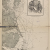
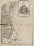
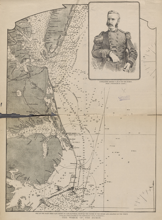
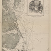
The Miriam and Ira D. Wallach Division of Art, Prints and Photographs: Print Collection, The New York Public Library. "The wreck of the Huron. Map of the coast from Cape Henry to Cape Hatteras, showing the course of the Huron and location of the wreck. (From the chart published by the hydrographic office, Washington.)" The New York Public Library Digital Collections. https://digitalcollections.nypl.org/items/9e279c0e-552a-d9e0-e040-e00a18067520
The Miriam and Ira D. Wallach Division of Art, Prints and Photographs: Print Collection, The New York Public Library. "The wreck of the Huron. Map of the coast from Cape Henry to Cape Hatteras, showing the course of the Huron and location of the wreck. (From the chart published by the hydrographic office, Washington.)" New York Public Library Digital Collections. Accessed April 18, 2024. https://digitalcollections.nypl.org/items/9e279c0e-552a-d9e0-e040-e00a18067520
The Miriam and Ira D. Wallach Division of Art, Prints and Photographs: Print Collection, The New York Public Library. The wreck of the Huron. Map of the coast from Cape Henry to Cape Hatteras, showing the course of the Huron and location of the wreck. (From the chart published by the hydrographic office, Washington.) Retrieved from https://digitalcollections.nypl.org/items/9e279c0e-552a-d9e0-e040-e00a18067520
<ref name=NYPL>{{cite web | url=https://digitalcollections.nypl.org/items/9e279c0e-552a-d9e0-e040-e00a18067520 | title=
(still image)
The wreck of the Huron. Map of the coast from Cape Henry to Cape Hatteras, showing the course of the Huron and location of the wreck. (From the chart published by the hydrographic office, Washington.)|author=Digital Collections, The New York Public Library |accessdate=April 18, 2024 |publisher=The New York Public Library, Astor, Lenox, and Tilden Foundations}}</ref>