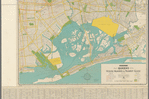
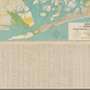


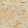
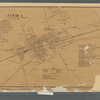
![Map of the Queens Boro[ugh], city of New York](https://images.nypl.org/index.php?id=5082597&t=b)
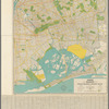
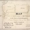
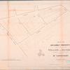
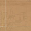
![[Long Island City] Reference Map of the property of New York Land & Warehouse Company showing desirable Factory, Water Front and Building Sites, First Ward, Borough of Queens, City of New York](https://images.nypl.org/index.php?id=5082548&t=b)
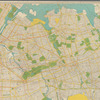
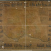
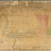
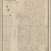
![[Long Island City, Queens] Record of searches in relation to the legal status of avenues and streets in the 1st Ward of the Borough of Queens.](https://images.nypl.org/index.php?id=5082549&t=b)
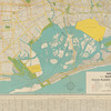
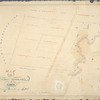
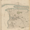
![[Rockaway Beach, Queens] Plan of drainage showing locations, sizes,& grades of sewers in sewerage district No. 10, Rockaway Beach watershed . . .](https://images.nypl.org/index.php?id=5082550&t=b)
- The Library Shop
- Privacy Policy
- Rules and Regulations
- Using the Internet
- Website Terms and Conditions
- Gifts of Materials to NYPL
-
© The New York Public Library, 2024
The New York Public Library is a 501(c)(3) | EIN 13-1887440
Lionel Pincus and Princess Firyal Map Division, The New York Public Library. "Hagstrom's map of Queens N.Y. City " The New York Public Library Digital Collections. 1945. https://digitalcollections.nypl.org/items/a5f2b250-3884-0137-2f3b-05f2f4ffb4c7
Lionel Pincus and Princess Firyal Map Division, The New York Public Library. "Hagstrom's map of Queens N.Y. City " New York Public Library Digital Collections. Accessed April 25, 2024. https://digitalcollections.nypl.org/items/a5f2b250-3884-0137-2f3b-05f2f4ffb4c7
Lionel Pincus and Princess Firyal Map Division, The New York Public Library. (1945). Hagstrom's map of Queens N.Y. City Retrieved from https://digitalcollections.nypl.org/items/a5f2b250-3884-0137-2f3b-05f2f4ffb4c7
<ref name=NYPL>{{cite web | url=https://digitalcollections.nypl.org/items/a5f2b250-3884-0137-2f3b-05f2f4ffb4c7 | title=
(cartographic)
Hagstrom's map of Queens N.Y. City , (1945)
|author=Digital Collections, The New York Public Library |accessdate=April 25, 2024 |publisher=The New York Public Library, Astor, Lenox, and Tilden Foundations}}</ref>