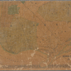
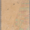
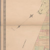
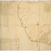
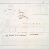
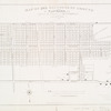
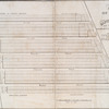
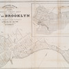
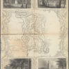
View this item elsewhere:

Title
Map of Kings County N.Y.
Names
Dripps, M. (Matthew) (Publisher)
J. & R. McLellan (Firm) (Printer)
Collection

Maps of New York City and State

New York City

Brooklyn

Dates / Origin
Date Issued: 1868
Place: 103 Fulton St., N.Y.
Publisher: Published by M. Dripps
Library locations
Lionel Pincus and Princess Firyal Map Division
Shelf locator: Map Div. 18-803
Topics
Brooklyn (New York, N.Y.)
Kings County (N.Y.)
New York (N.Y.)
New York (State) -- Kings County
New York (State) -- New York
New York (State) -- New York -- Brooklyn
Landowners
Landowners -- New York (State) -- New York
Real property -- New York (State) -- New York
Real property
Genres
Maps
Cadastral maps
Notes
Statement of responsibility: "Entered according to Act of Congress in the year 1868 by M. Dripps in the ... Southern District of New York."
Additional physical form: Available also through the Library of Congress Web site as a raster image.
Physical Description
Extent: 1 map on 2 sheets : color ; 80 x 65 cm, sheets 44 x 66 cm or smaller
Description
Shows Kings County consisting of the City of Brooklyn and 6 rural towns (townships) with property lines and names of owners of some property tracts. Shows radial distances from City Hall (Brooklyn). Hand colored to distinguish city wards (numbered) and town territories. Depths shown by contours and soundings. Oriented with north toward the upper left.
Type of Resource
Cartographic
Identifiers
Barcode: 33433087456335
NYPL catalog ID (B-number): b21659215
Universal Unique Identifier (UUID): 98d88d70-c5aa-012f-75e3-58d385a7bc34
Rights Statement
The New York Public Library believes that this item is in the public domain under the laws of the United States, but did not make a determination as to its copyright status under the copyright laws of other countries. This item may not be in the public domain under the laws of other countries. Though not required, if you want to credit us as the source, please use the following statement, "From The New York Public Library," and provide a link back to the item on our Digital Collections site. Doing so helps us track how our collection is used and helps justify freely releasing even more content in the future.

Item timeline of events

  • 1868: Issued (Approximate)
  • 2015: Digitized
  • 2024: Found by you!
  • 2025

MLA Format

Lionel Pincus and Princess Firyal Map Division, The New York Public Library. "Map of Kings County N.Y." The New York Public Library Digital Collections. 1868. https://digitalcollections.nypl.org/items/c4a7940a-dd61-7b78-e040-e00a180666d3

Chicago/Turabian Format

Lionel Pincus and Princess Firyal Map Division, The New York Public Library. "Map of Kings County N.Y." New York Public Library Digital Collections. Accessed April 25, 2024. https://digitalcollections.nypl.org/items/c4a7940a-dd61-7b78-e040-e00a180666d3

APA Format

Lionel Pincus and Princess Firyal Map Division, The New York Public Library. (1868). Map of Kings County N.Y. Retrieved from https://digitalcollections.nypl.org/items/c4a7940a-dd61-7b78-e040-e00a180666d3

Wikipedia Citation

<ref name=NYPL>{{cite web | url=https://digitalcollections.nypl.org/items/c4a7940a-dd61-7b78-e040-e00a180666d3 | title= (cartographic) 
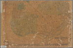
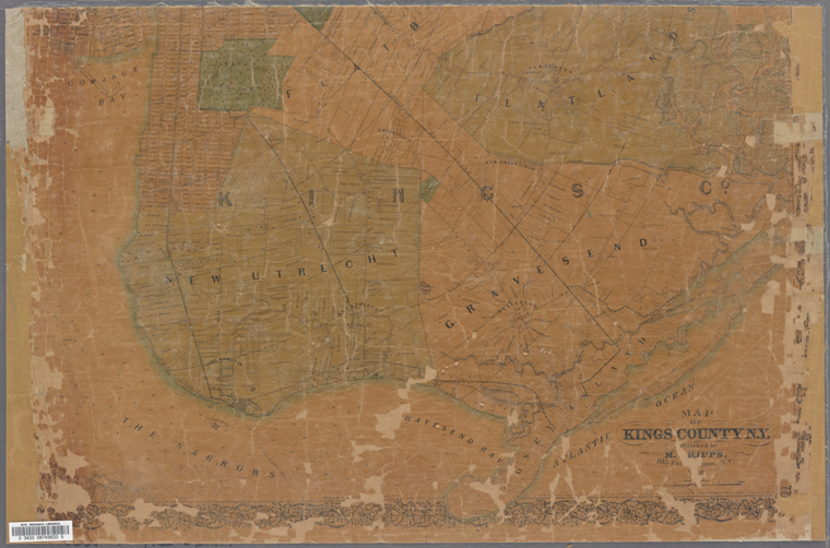
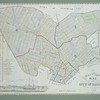
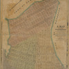
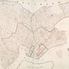
Map of Kings County N.Y., (1868) |author=Digital Collections, The New York Public Library |accessdate=April 25, 2024 |publisher=The New York Public Library, Astor, Lenox, and Tilden Foundations}}</ref>

Map of Kings County N.Y.