


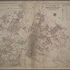


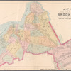
![Plate 4: [Bounded by Pomeroy Street, Jackson Avenue, Nott Avenue, Creek Street, Borden Avenue, West Avenue, Flushing Street, Front Street, Fifth Street, West Avenue, Nott Avenue, Vernon Avenue, Sanford Street, Sherman Street, Pierce Avenue, Lockwood Avenue and Webster Avenue.]](https://images.nypl.org/index.php?id=1523074&t=b)
![Plate 5: [Bounded by Dickinson Street, Woodside Avenue, Calvary Cemetery Road, Borden Avenue, Greenpoint Avenue, (Calvary Cemetery) Bradley Avenue, Review Avenue, Bradley Avenue, Orton Street, Nott Avenue and Jackson Avenue.]](https://images.nypl.org/index.php?id=1523075&t=b)
![Plate 6: [Bounded by Franklin Street, Flushing Avenue, Old Bowery Bay Blvd., Jackson Avenue, Western Avenue, Lockwood Avenue, Pierce Avenue, Sherman Street, Broadway, Boulevard, Fulton Street and Mills Street.]](https://images.nypl.org/index.php?id=1523076&t=b)
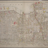
![Plate 7: [Bounded by Berrians Avenue, De Bevoise Avenue, Riker Avenue, Old Bowery Road, Cabinet Street, Flushing Avenue, Mills Street, Orchard Street, Remsen Street and Boulevard.]](https://images.nypl.org/index.php?id=1523077&t=b)
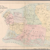
![Plate 8: [Bounded by Hillside Ave., Union Ave., Highland Ave., Grand St., Warwick Ave., Warwick Crescent, King St., Madison St., Fulton St., Wheeleer Ave., South St., George St., Sayres St., Merrick & Jamaica Plank Rd., South St., Jay St., Humboldt Blvd., Wyckoff Street, Liberty Ave., Guilford St., Chichester Ave., Kensington Ave., Johnston Ave., Rockway Tpke., Fulton St. & Hoffman Blvd.]](https://images.nypl.org/index.php?id=1523078&t=b)
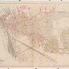
![Plate 9: [Bounded by Lawrence Avenue, Bayside Avenue, Congress Avenue, Myrtle Avenue, Whitestone Avenue, Bayside Avenue, Murray Avenue, Sanford Avenue, Parsons Avenue, Laburnum Avneue, Bowne Avenue, Oak Avenue, Jamaica Avenue, Mulberry Street, Colden Avenue, Franklin Pl., Summit Street, Bank Street.]](https://images.nypl.org/index.php?id=1523079&t=b)
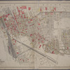
![Plate 10: [Bounded by Intersection Street, Franklin Street, Stevens Avenue, Main Street, Columbia Street, Stewart Avenue, Bennett Avenue, Fulton Street, William Street, Gerard Street, Greenwich Street, Grove Street, Prospect Street, Franklin Street, Front Street, Fulton Street, Cathedral Avenue, Atlantic Street and Cedar Valley Street.]](https://images.nypl.org/index.php?id=1523080&t=b)
![Plate 11: [Bounded by Bay Avenue, Franklin Avenue, Ocean Avenue, Healey Avenue, Bayview Avenue, The Strand, Bay Street, Mott Avenue, Grand Avenue, Crescent Place, Bay Street, Mott Avenue, Bay view Terrace, Cedar Avenue, Mott Avenue, Central Avenue, John Street, Wave Crest Avenue, and Bay Avenue.]](https://images.nypl.org/index.php?id=1523081&t=b)
![Plate 12: [Bounded by Central Avenue, Boulevard, Horton Avenue, Remsen Avenue, Mc Neil Avenue, Central Avenue, Lord Avenue, Greenwood, Jarvis Avenue, Cedar Hill Avenue, Fenwick Avenue, Somerset Avenue, Cedar Hill Avenue, Oak Street, Greenwood, Rue De. St. Felix, Coster Street and South Street.]](https://images.nypl.org/index.php?id=1523082&t=b)
![Plate 13: [Bounded by Rockaway Beach Boulevard, Averne Boulevard,... (Atlantic Ocean, Jamaica Bay), Eldert Avenue, Rockaway Beach Boulevard, Eastern Avenue, Triton Avenue and Tenth Avenue.]](https://images.nypl.org/index.php?id=1523083&t=b)
- The Library Shop
- Privacy Policy
- Rules and Regulations
- Using the Internet
- Website Terms and Conditions
- Gifts of Materials to NYPL
-
© The New York Public Library, 2024
The New York Public Library is a 501(c)(3) | EIN 13-1887440
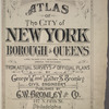
Lionel Pincus and Princess Firyal Map Division, The New York Public Library. "Atlas of the city of New York, borough of Queens, Long Island City, Newtown, Flushing, Jamaica, Far Rockaway, from actual surveys and official plans [1909]" The New York Public Library Digital Collections. 1909. https://digitalcollections.nypl.org/items/c572fce0-c5f9-012f-7d68-58d385a7bc34
Lionel Pincus and Princess Firyal Map Division, The New York Public Library. "Atlas of the city of New York, borough of Queens, Long Island City, Newtown, Flushing, Jamaica, Far Rockaway, from actual surveys and official plans [1909]" New York Public Library Digital Collections. Accessed April 24, 2024. https://digitalcollections.nypl.org/items/c572fce0-c5f9-012f-7d68-58d385a7bc34
Lionel Pincus and Princess Firyal Map Division, The New York Public Library. (1909). Atlas of the city of New York, borough of Queens, Long Island City, Newtown, Flushing, Jamaica, Far Rockaway, from actual surveys and official plans [1909] Retrieved from https://digitalcollections.nypl.org/items/c572fce0-c5f9-012f-7d68-58d385a7bc34
<ref name=NYPL>{{cite web | url=https://digitalcollections.nypl.org/items/c572fce0-c5f9-012f-7d68-58d385a7bc34 | title=

Atlas of the city of New York, borough of Queens, Long Island City, Newtown, Flushing, Jamaica, Far Rockaway, from actual surveys and official plans [1909], (1909)
|author=Digital Collections, The New York Public Library |accessdate=April 24, 2024 |publisher=The New York Public Library, Astor, Lenox, and Tilden Foundations}}</ref>
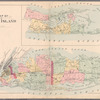
![Atlas of the city of New York, borough of Queens, Long Island City, Newtown, Flushing, Jamaica, Far Rockaway, from actual surveys and official plans [1909]](https://s3.amazonaws.com/repo-transcoded-web-media-thumnails/c5dab490-c5f9-012f-71bb-58d385a7bc34/c5dab490-c5f9-012f-71bb-58d385a7bc34-00002.jpg)