


![Central Park : memorial of the Common Council of the City of New York to the Legislature, approved June 11th, 1853...[title page]](https://images.nypl.org/index.php?id=5190254&t=b)


- The Library Shop
- Privacy Policy
- Rules and Regulations
- Using the Internet
- Website Terms and Conditions
- Gifts of Materials to NYPL
-
© The New York Public Library, 2024
The New York Public Library is a 501(c)(3) | EIN 13-1887440
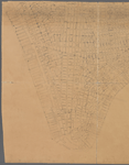
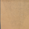
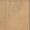
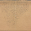
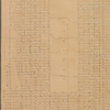
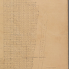
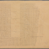
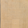
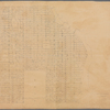
Lionel Pincus and Princess Firyal Map Division, The New York Public Library. "Data for population from census of 1910 " The New York Public Library Digital Collections. 1910. https://digitalcollections.nypl.org/items/e18ae4a0-09c0-0131-6ac5-58d385a7bbd0
Lionel Pincus and Princess Firyal Map Division, The New York Public Library. "Data for population from census of 1910 " New York Public Library Digital Collections. Accessed April 24, 2024. https://digitalcollections.nypl.org/items/e18ae4a0-09c0-0131-6ac5-58d385a7bbd0
Lionel Pincus and Princess Firyal Map Division, The New York Public Library. (1910). Data for population from census of 1910 Retrieved from https://digitalcollections.nypl.org/items/e18ae4a0-09c0-0131-6ac5-58d385a7bbd0
<ref name=NYPL>{{cite web | url=https://digitalcollections.nypl.org/items/e18ae4a0-09c0-0131-6ac5-58d385a7bbd0 | title=
(cartographic)
Data for population from census of 1910 , (1910)
|author=Digital Collections, The New York Public Library |accessdate=April 24, 2024 |publisher=The New York Public Library, Astor, Lenox, and Tilden Foundations}}</ref>