TitleIndian paths in the great metropolis
NamesA.R. Ohman Map Co. (Creator)Bolton, Reginald Pelham, 1856-1942 (Creator)Ohman, August R. (Creator)Museum of the American Indian, Heye Foundation (Publisher)
CollectionMaps of New York City and State
New York City
New York City & Vicinity
Dates / OriginDate Issued: 1912 (Inferred)Place: New York, N.Y.Publisher: Museum of the American Indian, Heye Foundation
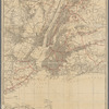
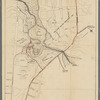
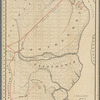
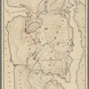
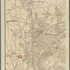
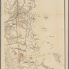
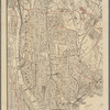
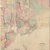
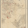
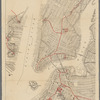
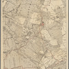
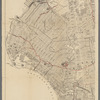
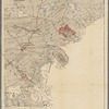
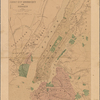
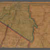
Table of ContentsMap I, Greater New York and contigous territory, showing the Indian paths, together with the approximate situation of all known Indian stations -- Map III, Werpoes, a village of the Manhattan Indians -- Map IV, Yorkville and East Harlem in aboriginal times -- Map V, Upper Manhattan, comprising the Inwood Valley, the Dyckman tract and Marble Hill -- Map VII A, The northwesterly part of the borough of the Bronx from Williamsbridge to the boundary of the city, and parts of Yonkers, Bronxville, Mount Vernon and Eastchester -- Map VII B, The district of Pelham Neck, within the borough of the Bronx, with Pelham Manor, and New Rochelle to Mamaroneck, together with the islands in the sound adjoining -- Map VII C, Southern part of the borough of the Bronx, from the Bronx Kills to Kingsbridge -- Map VII D, Southeastern part of the borough of the Bronx, the old township of Westchester, with Throgs Neck, and with Cornells Neck or Clasons Point -- Map VIII A, The lower end of Manhattan Island, as far north as Central Park, also the East River shorefront of Brooklyn, Williamsburg, and Greenpoint, and the New Jersey shoreline of Jersey City and Hoboken -- Map VIII B, The Long Island City and Newtown district within the borough and county of Queens, with a part of East New York, Bushwick, and Greenpoint, within the borough of Brooklyn or Kings County -- Map VIII C, The southwestern part of the borough of Brooklyn, or Kings County -- Map VIII D, The southeastern part of the borough of Brooklyn, or Kings County
Library locationsLionel Pincus and Princess Firyal Map DivisionShelf locator: Map Div. 19-4468
TopicsIndian trails -- New York (State) -- New YorkIndians of North America -- New York (State) -- New YorkNew York (N.Y.)
GenresMaps
NotesSource note: Appears in: Bolton, Reginald, Indian Paths of the Great Metropolis...New York, 1912.
Physical DescriptionExtent: 12 maps : color ; 56 x 44 cm or smaller
Type of ResourceCartographic
IdentifiersRLIN/OCLC: 1131723358NYPL catalog ID (B-number): b22042788Universal Unique Identifier (UUID): e2bf48f0-d038-0138-74f3-07b7a369d281
Rights StatementThe New York Public Library believes that this item is in the public domain under the laws of the United States, but did not make a determination as to its copyright status under the copyright laws of other countries. This item may not be in the public domain under the laws of other countries. Though not required, if you want to credit us as the source, please use the following statement, "From The New York Public Library," and provide a link back to the item on our Digital Collections site. Doing so helps us track how our collection is used and helps justify freely releasing even more content in the future.
Item timeline of events
-
-
-