Click to visit the main New York Public Library Homepage
The New York Public Library
Digital Collections
About Digital Collections
Browse
Search only public domain materials
Items
Collections
Divisions
Home
Search
Browse
About
Search only public domain materials
Items
Collections
Divisions
Digital Collections
Using Images
Using Data
Search
Keyword search
Show filters
Hide filters
Show Only Public Domain
topic
Landowners
5
Real property
5
Administrative and political divisions
2
name
Walling, Henry Francis, 1825-1888
2
Beers, D. G. (Daniel G.)
1
Beers, S. N
1
D.G. Beers & Co
1
Dunbar, Samuel Oliver, 1800-1883
1
More
Less
collection
Maps of North America
4
Century Company records
1
Maps of New York City and State
1
place
Massachusetts
2
Brownsville
1
Brownsville (Tenn.)
1
Haywood County
1
Haywood County (Tenn.)
1
More
Less
genre
Maps
5
Cadastral maps
3
Correspondence
1
publisher
D.G. Beers & Co
1
H.F. Walling
1
M.H. Tyler, Publisher
1
Saml. O. Dunbar
1
Smith, Gallup & Co
1
division
Map Division
5
Manuscripts and Archives Division
1
type
cartographic
5
text
1
Date Range
to
6 results found for:
17920
Sort by:
Relevance
Title
Date created
Date digitized
Sequence
m
Arey, Henry
Map of the town of Taunton: w…
abstract:
…
1:7,920
]. Includes 13
m
Map of the town of Norton, Br…
note:
…
1:7,920
].
m
Map of Haywood County, Tenn. …
abstract:
…. [Scale
1:7,920
. 40 rods
m
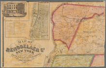
Map of Rensselaer Co., New Yo…
note:
…
1:7,920
. "Scale of village
Map of the city of Milwaukee,…
note:
Scale
1:7,920
(W 88°04ʹ15ʺ--W 87°51ʹ50ʺ/N