Click to visit the main New York Public Library Homepage
The New York Public Library
Digital Collections
About Digital Collections
Browse
Search only public domain materials
Items
Collections
Divisions
Home
Search
Browse
About
Search only public domain materials
Items
Collections
Divisions
Digital Collections
Using Images
Using Data
Search
Filtered search
Show filters
Hide filters
Show Only Public Domain
topic
Nautical charts
2
Colonies
1
World maps
1
name
Binneman, Walter
1
Browne, Christopher, active 1684-1712
1
Clark, James
1
Coronelli, Vincenzo, 1650-1718
1
Daniel, R. (Richard)
1
More
Less
collection
I. N. Phelps Stokes Collection of American Historical Prints
3
Lawrence H. Slaughter Collection of English maps, charts, globes, books and atlases
3
Maps of Europe
1
Maps of North America
1
place
Great Britain
2
Long Island (N.Y.)
2
New England
2
New Jersey
2
New York (N.Y.)
2
More
Less
genre
Maps
8
Prints
2
publisher
Chez I.B. Nolin
1
Printed for Nath: Crouch
1
Sold by Christopher Browne at the Globe near the West end of St. Pauls Church,
1
Sold by R. Morden at ye Atlas in Cornhill ye Royal Exchange,
1
by John Thornton ..
1
division
Map Division
5
Wallach Division: Print Collection
3
type
x
cartographic
still image
2
Date Range
to
8 results found
Filtering on:
x
Date
: 1685 - 1685
x
Type
: cartographic
Sort by:
Title
Date created
Date digitized
Sequence
m
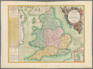
Le royaume d'Angleterre: divi…
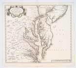
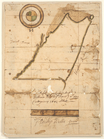
A new map of Virginia, Mary-l…
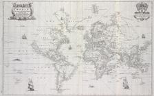
New mapp of the world accordi…
The English empire in America
A map of ye English Empire in…
Pas-kaart vande zee kusten va…
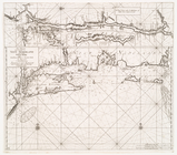
Survey of a "Certain neck of …
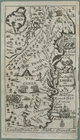
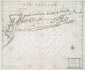
Part of New England New York …