Click to visit the main New York Public Library Homepage
The New York Public Library
Digital Collections
About Digital Collections
Browse
Search only public domain materials
Items
Collections
Divisions
Home
Search
Browse
About
Search only public domain materials
Items
Collections
Divisions
Digital Collections
Using Images
Using Data
Search
Filtered search
Show filters
Hide filters
Show Only Public Domain
topic
Real property
105
Cities & towns
88
Fire insurance
88
Administrative and political divisions
36
Railroads
32
More
Less
name
Sanborn Map Company
88
Bien, Joseph R
45
New York (N.Y.). Topographical Bureau
29
A.H. Mueller Co.,
22
Barthel, Otto
22
More
Less
collection
Atlases of New York City
117
Maps of North America
101
Atlases of the United States
85
Maps of New York City and State
59
Spezialkarte der Osterreichisch-Ungarischen Monarchie
3
More
Less
place
New York (State)
177
Bronx (New York, N.Y.)
37
New York
26
Atlantic City (N.J.)
22
Massachusetts
20
More
Less
genre
Maps
367
Atlases
85
Topographic maps
21
Cadastral maps
15
Geological maps
9
More
Less
publisher
Sanborn Map Company
88
Bien, Joseph R
45
Topographical Bureau
31
A.H. Mueller Co.,
22
D.L. Miller
18
More
Less
division
Map Division
364
Schomburg Manuscripts, Archives and Rare Books Division
2
Manuscripts and Archives Division
1
type
x
cartographic
text
4
still image
3
Date Range
to
367 results found
Filtering on:
x
Date
: 1895 - 1896
x
Type
: cartographic
Sort by:
Title
Date created
Date digitized
Sequence
The Matthews-Northrup up-to-d…
Plan of Bay Ridge Parkway
Map of the 23rd and 24th ward…
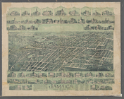
Jamaica, Long Island, N.Y
m
Rand McNally & Co.'s road map…
Map showing the proposed area…
m
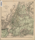
Vicinity of New York
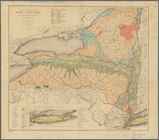
Economic and geologic map of …
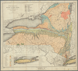
Economic and geologic map of …
Map of part of Jersey City, …
Map of the country about Bost…
Map of Chicago showing water …
Map of Mount Desert Island, M…
m
Map of Maine: Moosehead Lake …
Map of the City of Baltimore …
Map of the state of Wisconsin
Map of the state of Wisconsin
Map of the city of Sheffield,…
J.L. Hill Printing Co.'s map …
R.L. Polk & Co's map of the c…
m
Rand, McNally & Co.'s map sho…
Stranahan's map of Cleveland …
Map showing suburban subdivis…
Map of the city of Chicago sh…
Butler County, Iowa
m
Map of Rock Creek Park, being…
m
Map of Baltimore : as authori…
m
Map of the Denver & Rio Grand…
m
Map of Long Island: based upo…
m
Map of Chickamauga & Chattano…
Map of the city of Stockton
California (Nevada Co.), Neva…
m
Map of Stockton, Cal.
m
Map of Blackburn's addition t…
California (Los Angeles Co.) …
Map of the city of Oakland, B…
Map exhibiting the salt marsh…
Territory of New Mexico
Crocker's guide map of the ci…
Map of the City of San Franci…
Geological map of the Mother …
Map of the state of Ohio
The Hawaiian Islands: compile…
Map showing transfer system o…
Gould's official map of the c…
Railway and highway map of th…
Rand, McNally & Co.'s Massach…
Philadelphia and vicinity : P…
Topographical plan showing po…
Map of the State of Louisiana…
1
2
Previous
Next
1
2
Previous
Next