Click to visit the main New York Public Library Homepage
The New York Public Library
Digital Collections
About Digital Collections
Browse
Search only public domain materials
Items
Collections
Divisions
Home
Search
Browse
About
Search only public domain materials
Items
Collections
Divisions
Digital Collections
Using Images
Using Data
Search
Filtered keyword search
Show filters
Hide filters
Show Only Public Domain
topic
Cities and towns
1
Colonies
1
name
Melish, John, 1771-1822
2
Tanner, Henry Schenck, 1786-1858
2
Vallance, J. (John), 1770-1823
2
Colton, J. H. (Joseph Hutchins), 1800-1893
1
Finlayson, James
1
More
Less
collection
Maps of North America
5
Lawrence H. Slaughter Collection of English maps, charts, globes, books and atlases
1
Maps of the Oceans
1
place
x
North America
United States
4
America
2
Great Britain
2
West Indies
2
More
Less
genre
Maps
7
publisher
J.H. Colton
1
John Payne
1
Printed for Robert Sayer, No. 53 Fleet Street ...,
1
Printed for and sold by Henry Overton, at the White Horse without Newgate
1
Publish[e]d according to Act of Parliament by T. Jefferys, the corner of St. Martins Lane, Charing Cross,
1
More
Less
division
x
Map Division
type
cartographic
7
Date Range
to
7 results found for:
x
West Indies, British
Filtering on:
x
Division
: Map Division
x
Place
: North America
Sort by:
Relevance
Title
Date created
Date digitized
Sequence
m
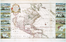
…, the
British
provinces, Mexico and the
West
Indies
note:
… of the
West
Indies
-- Map
… : with the contiguous
British
& Spanish
note:
Includes inset of the
West
Indies
… of the trading part of the
West
Indies
note:
…. ships in the
West
Indies
m
… with the contiguous
British
& Spanish
note:
… map of the
West
Indies
.
… and the
West
Indies
note:
… and the
West
Indies
. 1768.
… and the
West
Indies
… with the
West
India Islands :…