Click to visit the main New York Public Library Homepage
The New York Public Library
Digital Collections
About Digital Collections
Browse
Search only public domain materials
Items
Collections
Divisions
Home
Search
Browse
About
Search only public domain materials
Items
Collections
Divisions
Digital Collections
Using Images
Using Data
Search
Filtered keyword search
Show filters
Hide filters
Show Only Public Domain
topic
x
Administrative and political divisions
Counties
1
Indian reservations
1
Indians of North America
1
Landowners
1
More
Less
name
Blanchard, Rufus, 1821-1904
1
Cornell, Bradford and Baldwin
1
Johnson, A. J. (Alvin Jewett), 1827-1884
1
Richards & Co
1
Thayer, H. L. (Homer Lockwood), 1837-1904
1
More
Less
collection
Maps of North America
2
Maps of New York City and State
1
place
Colorado
1
Kansas
1
Missouri
1
New York (State)
1
Yonkers
1
More
Less
genre
Maps
3
Cadastral maps
1
publisher
Common Council
1
Published by A.J. Johnson
1
Published by Richards & Co
1
division
x
Map Division
type
cartographic
3
Date Range
to
3 results found for:
x
Thirde
Filtering on:
x
Division
: Map Division
x
Topic
: Administrative and political divisions
Sort by:
Relevance
Title
Date created
Date digitized
Sequence
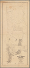
Map of the city of Yonkers,
Third
Ward
Thayer's map of Colorado
Johnson's Missouri and Kansas
abstract:
… eastern
third
of Kansas.