Click to visit the main New York Public Library Homepage
The New York Public Library
Digital Collections
About Digital Collections
Browse
Search only public domain materials
Items
Collections
Divisions
Home
Search
Browse
About
Search only public domain materials
Items
Collections
Divisions
Digital Collections
Using Images
Using Data
Search
Filtered keyword search
Show filters
Hide filters
Show Only Public Domain
topic
Real property
2
Administrative and political divisions
1
Maps
1
Railroads
1
Roads
1
More
Less
name
Perkins, Charles
2
Barnet, J
1
Chatelain, Henri Abraham
1
Goerck, Casimir
1
Lauder, J. C
1
More
Less
collection
Maps of New York City and State
5
Maps of North America
4
place
Brooklyn (New York, N.Y.)
4
New York (State)
2
North America
2
United States
2
Bushwick (New York, N.Y.)
1
More
Less
genre
Maps
9
Cadastral maps
1
Road maps
1
publisher
x
s.n
division
x
Map Division
type
cartographic
9
Date Range
to
9 results found for:
x
11
Filtering on:
x
Division
: Map Division
x
Publisher
: s.n.
Sort by:
Relevance
Title
Date created
Date digitized
Sequence
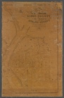
1841, showing the dates of th…
parent:
b8e12c20-c52a-012f-
11
bb-3c075448cc4b
Skeleton map showing the rail…
parent:
b8e12c20-c52a-012f-
11
bb-3c075448cc4b
Map of reconnaissance exhibit…
parent:
b8e12c20-c52a-012f-
11
bb-3c075448cc4b
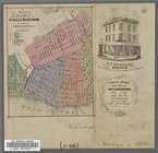
Map of the City of Williamsbu…
m
Plan of property situate in t…
m
Plan of property situate in t…
m
Peremptory sale of a suburban…
Carte contenant le royaume du…
note:
Scale [ca. 1:
11
,500,000] (W 114°--W 59°/N
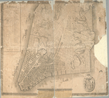
Plan of the city of New-York