Click to visit the main New York Public Library Homepage
The New York Public Library
Digital Collections
About Digital Collections
Browse
Search only public domain materials
Items
Collections
Divisions
Home
Search
Browse
About
Search only public domain materials
Items
Collections
Divisions
Digital Collections
Using Images
Using Data
Search
Filtered keyword search
Show filters
Hide filters
Show Only Public Domain
topic
Real property
438
Fire insurance
388
Cities & towns
303
City planning
69
Social conditions
68
More
Less
name
Sanborn Map Company
388
Bromley, George Washington
93
Bromley, Walter Scott
93
G.W. Bromley & Co
93
M.I.T. Press
68
More
Less
collection
Atlases of New York City
715
Maps of New York City and State
61
Lawrence H. Slaughter Collection of English maps, charts, globes, books and atlases
4
Atlases of the United States
2
Cartographic materials from the Emmet collection of manuscripts etc. relating to American history
2
place
New York (State)
525
Staten Island (New York, N.Y.)
363
New York
180
New York (N.Y.)
130
New York Metropolitan Area
13
More
Less
genre
Maps
779
Topographic maps
91
Cadastral maps
7
Manuscript maps
5
Indexes
3
More
Less
publisher
Sanborn Map Company
303
G.W. Bromley & Co
93
Sanborn Map Co
84
MIT Press
68
E. Robinson Co
37
More
Less
division
x
Map Division
type
cartographic
710
still image
69
text
6
Date Range
to
784 results found for:
x
"staten island" map
Filtering on:
x
Division
: Map Division
Sort by:
Relevance
Title
Date created
Date digitized
Sequence
Results 751 - 784
Annadale, Arden Heights, Bay …
collection:
Staten
Island
Annadale, Arden Heights, Bay …
collection:
Staten
Island
Annadale, Arden Heights, Bay …
collection:
Staten
Island
…, New York,
Staten
Island
, & Long Island.
note:
… to Early
Maps
of the Middle
Arrochar, Bloomfield, Bull's …
collection:
Staten
Island
Arrochar, Bloomfield, Bull's …
collection:
Staten
Island
Arrochar, Bloomfield, Bull's …
collection:
Staten
Island
Arrochar, Bloomfield, Bull's …
collection:
Staten
Island
Arrochar, Bloomfield, Bull's …
collection:
Staten
Island
… Street,
Staten
Island
…; Including South St,
Staten
Island
Ferry, Hamilton Av
… Island,
Staten
Island
note:
Mapping
the Nation (NEH grant, 2015-2018)…
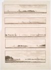
Views of the entrance to New …
note:
…, & the east bluff of
Staten
Island
) bearing S. b[y] W.
… road
map
of the country
Brooklyn, from Rand McNally metropolitan
map
note:
…, Queens,
Staten
Island
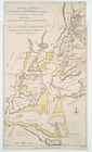
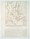
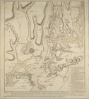
The seat of action between th…
note:
LC
Maps
of North America, 1750-1789, 1146
The seat of action between th…
note:
LC
Maps
of North America, 1750-1789, 1146
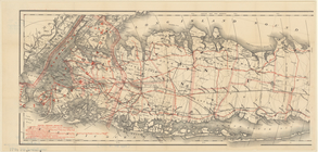
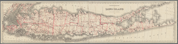
Colton's road
map
of Long Island
note:
… of
Staten
Island
, New Jersey
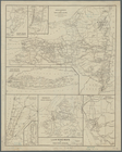
m
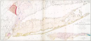
Geological
map
of Long &
Staten
islands
note:
Includes inset "
Map
of New-York Island."…
Map
of the port & vicinity of New York
m
Hammond's standard
map
of the city of New
note:
Includes inset
map
of
Staten
Island
.
m
Map
of Long Island and adjacent areas
note:
…
Staten
Island
L.A.W. road
maps
of New York Division
note:
Mapping
the Nation (NEH grant, 2015-2018) …
m
Colton's road
map
of Long Island
note:
… of
Staten
Island
, New Jersey
… and
Staten
Islands
, and part
note:
Haskell, D.C. Manhattan
maps
, 534
m
Library
map
1908
abstract:
…, and inset
map
of
Staten
Island
. Also shows
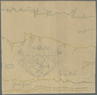
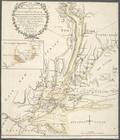
Chart and plan of the harbour…
note:
… to Early
Maps
of the Middle
m
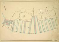
Double Page Plate No. 5: Rich…
collection:
… in a series of
maps
… Island,
Staten
Island
note:
NYPL copy in
Map
Div. 01-1773 lacks
… Island,
Staten
Island
note:
… to Early
Maps
of the Middle
… Island,
Staten
Island
note:
… to Early
Maps
of the Middle
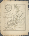
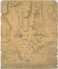
Carte de la baye et riviere d…
note:
LC
maps
of North America, 1750-1789, 1229
m
Map
of Long Island with the environs of New-York
note:
….,
Staten-Island
-- City of Newark
m
Map
of Long Island with the environs of New-York
note:
….,
Staten-Island
-- City of Newark
1
2
3
4
Previous
Next
1
2
3
4
Previous
Next