Click to visit the main New York Public Library Homepage
The New York Public Library
Digital Collections
About Digital Collections
Browse
Search only public domain materials
Items
Collections
Divisions
Home
Search
Browse
About
Search only public domain materials
Items
Collections
Divisions
Digital Collections
Using Images
Using Data
Search
Filtered keyword search
Show filters
Hide filters
Show Only Public Domain
topic
Administrative and political divisions
19
Railroads
6
Roads
5
Steamboat lines
5
Real property
4
More
Less
name
x
Geo. H. Walker & Co
Alfred Mudge and Son
2
Littlefield Directory Publishing Co
2
Massachusetts. Board of Railroad Commissioners
2
New England Navigation Company
2
More
Less
collection
Maps of North America
38
Maps of New York City and State
4
place
Massachusetts
24
Boston
15
Boston (Mass.)
13
Boston Metropolitan Area (Mass.)
8
Boston Harbor (Mass.)
4
More
Less
genre
x
Maps
Cadastral maps
3
Topographic maps
3
Aerial views
2
Road maps
2
More
Less
publisher
Geo. H. Walker & Co
26
publisher not identified
4
Walker Lith. & Pub. Co
2
Wright & Potter Ptg. Co
2
A. Mudge & Son
1
More
Less
division
Map Division
42
type
cartographic
42
Date Range
to
42 results found for:
x
Geo
Filtering on:
x
Genre
: Maps
x
Name
: Geo. H. Walker & Co.
Sort by:
Relevance
Title
Date created
Date digitized
Sequence
Road map of the Albany-Troy d…
note:
Copyright 1897 by
Geo
. H. Walker & Co
Crawford's map of the White M…
note:
From original surveys by
Geo
. T
Map of Somerville, [Mass.]: p…
note:
…"Copyright 1895, by
Geo
. H. Walker & Co."…
Rhode Island
note:
…"Copyright 1898 by
Geo
. H. Walker & Co."…
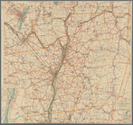
New map of Boston, giving all…
note:
…"Copyrighted 1894 & 1897 by
Geo
. H. Walker
Map of Boston and vicinity
note:
Geo
. H. Walker & Co., engravers, Boston.
Freight terminal map of New Y…
note:
Geo
. H. Walker & Co.
m
Map of Boston showing locatio…
note:
… copyright 1898 by
Geo
. H
Narragansett Bay and vicinity
note:
…"Copyright 1892 by
Geo
. H. Walker & Co."…
m
Map of Maine: Moosehead Lake …
Map of Connecticut
Plymouth town, Mass.
Map of Berkshire County
Boston Harbor
Map of the towns of Plymouth …
note:
…"Copyright 1899 by
Geo
. H. Walker & Co
Map of Berkshire hills, Massa…
Railroad and post office map …
The North Shore and part of M…
Boston and surroundings
City of Malden: [Massachusett…
Map of Cambridge and Somervil…
Railroad and post office map …
Indexed map of Boston
Map of Boston and vicinity: s…
Boston and surroundings
Map of the city of Malden
note:
…"Copyright by
Geo
. H. Walker & Co
Boston Harbor
m
Boston and surroundings
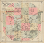
Map of the Vilas Preserve and…
note:
…, N.Y. ;
Geo
. H. Walker
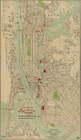
Topographical map of the stat…
Freight terminal map of New Y…
Map of Everett: [Massachusett…
Map of Boston
Map of the Town of Milford an…
Map of the railroads of the s…
Map of New England City, Dade…
Map of the railroads of the S…
Historical map of Sanbornton
Map of the city of Boston and…
Plan showing land owned by th…
Plan of Boston proper, showin…
Historical maps of Sanbornton
End of results
|
Top