Click to visit the main New York Public Library Homepage
The New York Public Library
Digital Collections
About Digital Collections
Browse
Search only public domain materials
Items
Collections
Divisions
Home
Search
Browse
About
Search only public domain materials
Items
Collections
Divisions
Digital Collections
Using Images
Using Data
Search
Filtered keyword search
Show filters
Hide filters
Show Only Public Domain
topic
Railroads
16
History
12
Canals
6
Distances, etc
6
Administrative and political divisions
4
More
Less
name
Tanner, Henry Schenck, 1786-1858
8
Colton, J. H. (Joseph Hutchins), 1800-1893
4
Mitchell, S. Augustus (Samuel Augustus), 1792-1868
4
Young, J. H. (James Hamilton)
4
American Revolution (1775-1783)
3
More
Less
collection
Maps of North America
55
Maps of New York City and State
6
Atlases of the United States
3
Lawrence H. Slaughter Collection of English maps, charts, globes, books and atlases
2
place
x
United States
Mexico
9
United States -- Maps
9
North America
7
Hudson River (N.Y. and N.J.)
5
More
Less
genre
x
Maps
Illustrations
2
Nautical charts
2
Bathymetric maps
1
Charts
1
More
Less
publisher
Henry Schenck Tanner
3
J.H. Colton
3
s.n
3
G. Woolworth Colton
2
Henry Tanner,
2
More
Less
division
Map Division
66
type
cartographic
65
still image
4
text
1
Date Range
to
66 results found for:
x
Tables
Filtering on:
x
Genre
: Maps
x
Place
: United States
Sort by:
Relevance
Title
Date created
Date digitized
Sequence
Der amerikanische Continent: …
note:
… reference
tables
, one
Ocilla River, Florida
note:
Includes text and
tables
.
m
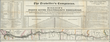
New travelling and commercial…
note:
Includes 3
tables
of distances.
Map of the United States show…
note:
Includes
tables
showing the "areas
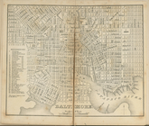
Baltimore.
collection:
…. With
tables
of distances
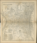
Philadelphia and environs.
collection:
…. With
tables
of distances
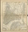
New-York.
collection:
…. With
tables
of distances
Map of the roads, canals and …
note:
Includes
tables
of steam boat routes
A map of Mexico, Louisiana, a…
note:
Includes
tables
of latitude, longitude, Native
Topographical map of the orig…
note:
Includes text and population
tables
.
m
Schonberg's imperial map of t…
note:
Includes
tables
and diagram of principal
… country ... : also a
table
note:
….) and
tables
of distances
United States of America
note:
…
tables
.
m
Watson's new county and railr…
note:
Includes
tables
with population and railroad
m
Maps of the picturesque Catsk…
A map of the confluence of th…
note:
Includes
tables
of references.
m
United States of America, 1834
note:
…, and statistical
tables
.
Leavitt's map with views of t…
note:
Includes
tables
of distances between stations
The states of Ohio, Indiana &…
note:
Includes population
tables
of counties
Map of the routes through the…
note:
Accompanied by: Routes and
tables
Skeleton map showing the rail…
note:
Includes
tables
of travel times.
m
Map of the United States
note:
…
tables
of the United
m
Mitchell's new national map e…
note:
…, and statistical
tables
A.R. Roessler's latest map of…
abstract:
… of Texas," with "
Tables
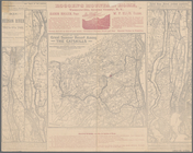
The Theatre of war in North A…
note:
…," "Evan's polymetric
table
of America, and "A
table
…, with
table
of distances, etc.
note:
Includes
table
of distances and text.
Map of the United States of A…
note:
Includes
table
m
Colton's map of the United St…
note:
Includes
table
The Country twenty five miles…
note:
… "Chronological
table
of the most
War Department weather map: N…
abstract:
…. Includes
table
Map of the United States : wi…
note:
… and statistical
table
The country twenty five miles…
note:
… "Chronological
table
of the most
m
Lay's map of the United States
note:
… "Statistical
table
of the United States" and
table
m
Map of the United States with…
note:
Includes statistical
table
and inset
Mitchell's travellers guide t…
note:
… routes, statistical
table
Map of the United States and …
note:
…, historical notes, "
Table
of Distances", and "
Table
m
Johnson's new illustrated & e…
note:
Contains
table
Map of the Vermont Central Ra…
note:
…
table
.
m
Johnson's new illustrated & e…
note:
…,
table
of distances, "Statistical
table
from
Map of the United States of A…
note:
Includes
table
of "Popular and electoral vote
Map of the U.S.
abstract:
…
table
with railroads
A new map of Carolina
abstract:
… by soundings. Includes a "
Table
Map of the United States, con…
note:
Includes statistical
table
listing
m
Map of the United States
note:
Includes population
table
and portrait
Map of the United States, the…
note:
… California and distance
table
.
m
Lloyd's new county map of the…
note:
Includes
table
of population and inset
m
Rand, McNally and Co.'s gener…
abstract:
Relief shown by hachures. Includes
table
Map of the seat of war in Vir…
note:
…"
Table
of distances from Norfolk
m
G. Woolworth Colton's new gui…
note:
…
table
.
Plan of the battle fought nea…
abstract:
Shows positions of opposing forces, and
table