Click to visit the main New York Public Library Homepage
The New York Public Library
Digital Collections
About Digital Collections
Browse
Search only public domain materials
Items
Collections
Divisions
Home
Search
Browse
About
Search only public domain materials
Items
Collections
Divisions
Digital Collections
Using Images
Using Data
Search
Filtered keyword search
Show filters
Hide filters
Show Only Public Domain
topic
Nautical charts
10
Harbors
4
History
3
Indian land transfers
3
Land grants
3
More
Less
name
United States Coast Survey
10
Bache, A. D. (Alexander Dallas), 1806-1867
8
Mathiot, G
7
Jenkins, T. A
6
Hassler, F. R. (Ferdinand Rudolph), 1770-1843
5
More
Less
collection
Maps of New York City and State
5
Maps of North America
5
Lawrence H. Slaughter Collection of English maps, charts, globes, books and atlases
3
place
New Jersey
7
New York (N.Y.)
4
New York Harbor (N.Y. and N.J.)
4
New York Metropolitan Area
4
North Carolina
4
More
Less
genre
x
Maps
Nautical charts
5
Bathymetric maps
4
publisher
Printed by James Parker, and a few Copies are to be Sold by him, and Benjamin Franklin, in Philadelphia;
3
Survey of the Coast of the United States
3
U.S. Coast Survey
3
U.S. Coast Survey Office
2
The Survey
1
More
Less
division
Map Division
13
type
cartographic
13
Date Range
to
13 results found for:
x
Jenkins, T. A
Filtering on:
x
Genre
: Maps
x
Rights
: Public Domain
Sort by:
Relevance
Title
Date created
Date digitized
Sequence
Preliminary chart of entrance…
parent:
32958040-b143-0132-2eae-58d385
a
7bbd0
Preliminary chart of Frying P…
parent:
cc2c56
a
0-4226-0135-e4b0-3d6ce13e4480
m
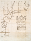
Map of New-York Bay and Harbo…
parent:
04b4c260-c5ab-012f-f198-58d385
a
7bc34
Albemarle Sound, N. Carolina,…
parent:
78423d90-3ff5-0135-e7c6-0d7
a
3815
a
372
Map of New-York Bay and Harbo…
parent:
05
a
170d0-c5ab-012f-1c11-58d385
a
7bc34
Map of New-York Bay and Harbo…
parent:
063
a
2480-c5ab-012f-719b-58d385
a
7bc34
Sketch of Frying-Pan Shoals a…
parent:
52
a
622d0-b144-0132-78c9-58d385
a
7bbd0
m
Map of New-York Bay and Harbo…
parent:
039e5860-c5ab-012f-7163-58d385
a
7bc34
Preliminary chart of the sea …
parent:
23
a
56540-3e4f-0135-378b-0deb9ecc3f28
Long Island Sound (western sh…
parent:
587bdb60-c5aa-012f-f824-58d385
a
7bc34
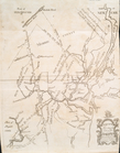
Map no. II : [to accompany A …
parent:
d06f2f60-c5d4-012f-9
a
29-58d385
a
7bc34
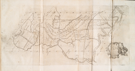
Map no. I : [to accompany A b…
parent:
cfbcc870-c5d4-012f-7909-58d385
a
7bc34
Map no. III : [to accompany A…
parent:
d15219b0-c5d4-012f-36
a
1-58d385
a
7bc34
End of results
|
Top