Click to visit the main New York Public Library Homepage
The New York Public Library
Digital Collections
About Digital Collections
Browse
Search only public domain materials
Items
Collections
Divisions
Home
Search
Browse
About
Search only public domain materials
Items
Collections
Divisions
Digital Collections
Using Images
Using Data
Search
Filtered keyword search
Show filters
Hide filters
Show Only Public Domain
topic
x
Administrative and political divisions
Railroads
17
Landowners
11
Altitudes
10
Canals
9
More
Less
name
Mitchell, S. Augustus (Samuel Augustus), 1792-1868
9
Tanner, Henry Schenck, 1786-1858
6
Colton, J. H. (Joseph Hutchins), 1800-1893
5
Walling, Henry Francis, 1825-1888
5
Smith, Robert Pearsall, 1827-1898
4
More
Less
collection
Maps of North America
51
Maps of New York City and State
29
Lawrence H. Slaughter Collection of English maps, charts, globes, books and atlases
1
place
New York (State)
28
Massachusetts
9
Erie Canal (N.Y.)
8
Connecticut
6
Georgia
5
More
Less
genre
x
Maps
Cadastral maps
6
Road maps
2
Topographic maps
2
Tourist maps
2
More
Less
publisher
S. Augustus Mitchell
7
publisher not identified
6
J.H. Colton
5
H.S. Tanner
3
Gaylord Watson
2
More
Less
division
Map Division
81
type
cartographic
81
still image
2
text
2
Date Range
to
81 results found for:
x
Tables
Filtering on:
x
Genre
: Maps
x
Topic
: Administrative and political divisions
Sort by:
Relevance
Title
Date created
Date digitized
Sequence
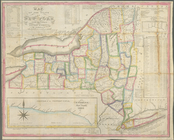
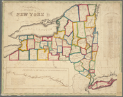
Map of the state of New York …
note:
…
tables
, statistical
tables
and elevation
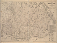
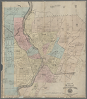
Map of the borough of Brookly…
abstract:
…. Includes
tables
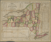
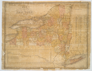
Map of the State of New York …
note:
Includes text and statistical
tables
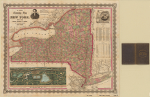
Map of the state of New York …
note:
Includes inset statistical
tables
m
Map of the City of Utica, One…
note:
Includes statistical
tables
and local
m
A new township map of the sta…
note:
… "Excelsior," 2
tables
of 1860
Colton's railroad & township …
note:
Includes
tables
of statistics.
Massachusetts and Rhode Island
note:
Includes population "Statistical
Tables
m
Watson and Adams new topograp…
abstract:
…"; 3
tables
Vermont, from actual survey :…
note:
Includes
tables
: Census of Vermont, A.D
Labor commissioner's official…
abstract:
…,
tables
, and 6 vignettes
m
Nell's topographical & townsh…
abstract:
…
tables
of Area
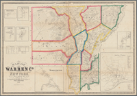
Map of Warren Co., New York
note:
Includes statistical
tables
, and insets
m
Hardee's geographical, histor…
abstract:
…
tables
, and "Profile
The tourist's pocket map of t…
abstract:
…. Includes text,
tables
list
m
Map of the state of New-York …
note:
Includes indexed
tables
of references
m
Watson and Adams new topograp…
abstract:
…
tables
of "Civil
New Hampshire & Vermont
note:
Includes population
tables
.
Official map of Nebraska : sh…
abstract:
…. Includes
tables
A map of the state of Virgini…
abstract:
… and geology, and
tables
The Empire State, New York : …
note:
Includes notes and 3
tables
Lloyd's official map of the s…
abstract:
…, advertisements,
tables
m
Map of Clinton Co., New York:…
abstract:
… of towns, 4 views,
tables
m
Map of the state of New-York:…
note:
Includes indexed
tables
of references
Nell's new topographical & to…
abstract:
…
tables
of Area
m
Colton's map of the state of …
abstract:
…. Includes inset
tables
Colton's sectional map of the…
abstract:
…," and statistical
tables
on "State
m
Map of Orange and Rockland Co…
note:
Also Includes
table
Map of the western part of th…
note:
Includes
tables
of statistics and notes.
m
Map of the state of Virginia
note:
Includes geological remarks,
tables
m
Mitchell's new national map e…
note:
…, and statistical
tables
Map of the state of Virginia
note:
Includes geological remarks,
tables
m
Map of the states of Kentucky…
abstract:
… and distance
tables
for steam
m
A map of South Carolina and a…
abstract:
… by soundings. Includes
tables
Colton's new illustrated & em…
note:
… of "Authorities,"
table
m
Topographical map of the stat…
note:
Includes
table
Map of the State of New York
note:
…
table
.
Distance map of the state of …
note:
… in the state [diagram and
table
m
Johnson's new illustrated & e…
note:
Contains
table
Map of Connecticut
note:
Includes a
table
of 1890 population
Map of Bennington County, Ver…
abstract:
… in the county; Statistics
table
m
Johnson's new illustrated & e…
note:
…,
table
of distances, "Statistical
table
from
Map of the city of Rochester
note:
Includes city acreage statistical
table
Map of the State of New York
note:
…
table
of cities
Russell's map of Massachusetts
note:
Includes Includes a
table
of distance
Neueste Karte von New York : …
note:
Includes inset mileage
table
Map of the State of New York
note:
Includes statistical
table
.
m
Map of Suffolk Co., L.I., New…
note:
… statistical
table
, distance
table
, local business
Franklin County
abstract:
…. Title from atlas'
table
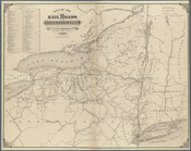
Map of the railroads of the S…
note:
Includes
table
detailing "Length of rail