Click to visit the main New York Public Library Homepage
The New York Public Library
Digital Collections
About Digital Collections
Browse
Search only public domain materials
Items
Collections
Divisions
Home
Search
Browse
About
Search only public domain materials
Items
Collections
Divisions
Digital Collections
Using Images
Using Data
Search
Filtered keyword search
Show filters
Hide filters
Show Only Public Domain
topic
City planning
123
Social conditions
123
History
10
Real property
6
Landowners
5
More
Less
name
M.I.T. Press
123
New York (N.Y.). City Planning Commission
123
Montanus, Arnoldus, 1625?-1683
7
Ogilby, John, 1600-1676
7
Bromley, George Washington
3
More
Less
collection
Atlases of New York City
126
Maps of New York City and State
13
Maps of North America
11
Lawrence H. Slaughter Collection of English maps, charts, globes, books and atlases
9
I. N. Phelps Stokes Collection of American Historical Prints
7
More
Less
place
New York (State)
135
New York (N.Y.)
133
New York
127
America
9
New England
7
More
Less
genre
x
Maps
Prints
10
Illustrations
9
Aerial views
6
Advertisements
3
More
Less
publisher
MIT Press
123
Printed by the author, and are to be had at his house
7
G.W. Bromley & Co
3
T.R. Callender & Co
2
A.R.Z. Dawson
1
More
Less
division
Map Division
162
Wallach Division: Print Collection
8
Wallach Division: Picture Collection
4
George Arents Collection
2
Manuscripts and Archives Division
2
More
Less
type
x
still image
cartographic
42
text
9
Date Range
to
183 results found for:
x
One Wall Street (New York, N.Y. : 1931- )
Filtering on:
x
Genre
: Maps
x
Type
: still image
Sort by:
Relevance
Title
Date created
Date digitized
Sequence
m
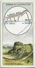
Hadrian's
Wall
.
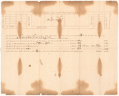
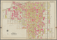
Town & village of Ovid, Seneca Co.,
N
.
Y
.
use:
… partner (e.g.,
New
York
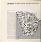
Lower Manhattan, The Battery,
Wall
Street
Lower Manhattan, The Battery,
Wall
Street
Lower Manhattan, The Battery,
Wall
Street
Lower Manhattan, The Battery,
Wall
Street
Lower Manhattan, The Battery,
Wall
Street
Lower Manhattan, The Battery,
Wall
Street
Lower Manhattan, The Battery,
Wall
Street
New
York
.
use:
… partner (e.g.,
New
York
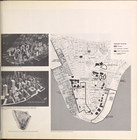
… Manhattan, The Battery,
Wall
Street
, Civic Center
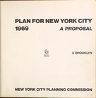
collection:
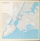
Plan for
New
York
City 1969: a proposal
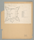
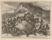
The Fort in
New
Yorke
use:
… partner (e.g.,
New
York
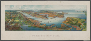
Greatest
New
York
…
use:
… partner (e.g.,
New
York
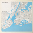
New
York
's Neighborhoods
m
Florance, George
N
use:
… partner (e.g.,
New
York
… the
Walls
of Taxamalco.
use:
… partner (e.g.,
New
York
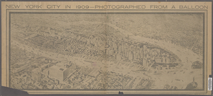
m
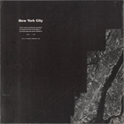
New
York
City in 1909
use:
… partner (e.g.,
New
York
New
York
City Government
New
York
State Facilities
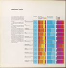
Industry in
New
York
City
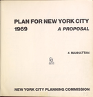
collection:
Plan for
New
York
City 1969: a proposal
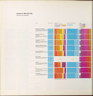
Industry in
New
York
City
collection:
Plan for
New
York
City 1969: a proposal
… Avenue, East
New
York
use:
… partner (e.g.,
New
York
m
Map of Ontario County,
New
York
use:
… partner (e.g.,
New
York
m
Plans for a
New
York
State prison
use:
… partner (e.g.,
New
York
Industry in
New
York
City (cont.)…
collection:
Plan for
New
York
City 1969: a proposal
Industry in
New
York
City (cont.)…
collection:
Plan for
New
York
City 1969: a proposal
New
York
City (North West)…
New
York
City (North East)…
New
York
City (South West)…
New
York
City (South East)…
m
Map of Clinton Co.,
New
York
use:
… partner (e.g.,
New
York
m
Map of Dutchess Co.,
New
York
use:
… partner (e.g.,
New
York
Temple Cell with
Walls
bedaub'd two
use:
… partner (e.g.,
New
York
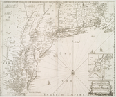
A
new
map of
New
England,
New
York
,
New
I[J
use:
… partner (e.g.,
New
York
… Place, East
New
York
use:
… partner (e.g.,
New
York
Plan for
New
york
Plan for
New
york
Plan for
New
york
Plan for
New
york
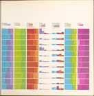
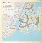
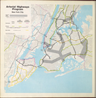
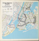
Arterial highways program
New
York
City
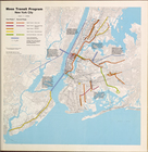
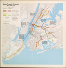
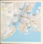
Mass Transit program
New
York
City
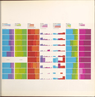
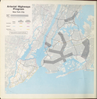
Arterial highways program
New
York
City
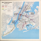
Mass Transit program
New
York
City
Arterial highways program
New
York
City
Mass Transit program
New
York
City
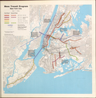
Mass Transit program
New
York
City
Arterial highways program
New
York
City
Mass Transit Program
New
York
City
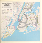
Arterial Highways Program
New
York
City
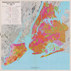
Neighborhood Improvement
New
York
City 1969