Click to visit the main New York Public Library Homepage
The New York Public Library
Digital Collections
About Digital Collections
Browse
Search only public domain materials
Items
Collections
Divisions
Home
Search
Browse
About
Search only public domain materials
Items
Collections
Divisions
Digital Collections
Using Images
Using Data
Search
Filtered keyword search
Show filters
Hide filters
Show Only Public Domain
topic
Railroads
53
Administrative and political divisions
46
Canals
19
Real property
18
Nautical charts
11
More
Less
name
United States Coast Survey
8
G.W. & C.B. Colton & Co
6
Carrère & Hastings
5
Connecticut. Commission on Boundary between the States of New York and Connecticut
5
G.W. Bromley & Co
5
More
Less
collection
Maps of North America
128
Maps of New York City and State
57
Lawrence H. Slaughter Collection of English maps, charts, globes, books and atlases
13
Atlases of the United States
10
A plan of the city of Hartford
5
More
Less
place
Connecticut
122
New York (State)
73
Massachusetts
44
New England
39
Rhode Island
34
More
Less
genre
x
Maps
Cadastral maps
11
Atlases
9
Early maps
6
Plans
5
More
Less
publisher
publisher not identified
29
Case, Lockwood & Brainard Co
5
G.W. & C.B. Colton & Co
5
G.W. Bromley & Co
5
The Commissioners
5
More
Less
division
Map Division
215
General Research Division
5
Wallach Division: Print Collection
2
Rare Book Division
1
type
cartographic
223
still image
1
Date Range
to
223 results found for:
x
Connecticut
Filtering on:
x
Genre
: Maps
Sort by:
Relevance
Title
Date created
Date digitized
Sequence
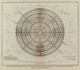
Isothermal chart, or, View of…
note:
… of
Connecticut
."…
Rand Mcnally official detaile…
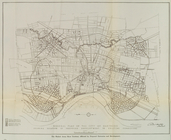
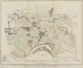
General plan of the city of H…
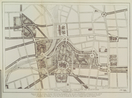
Diagrammatic plan for a moder…
General plan of the city of H…
Plan of the central section o…
Suggested type of layout for …
m
Rand McNally & Co.'s road map…
m
… of
Connecticut
Map of the state of New York:…
abstract:
Covers all of Vermont and
Connecticut
Map of the rail roads of the …
abstract:
… and
Connecticut
, substantial
Map of the rail-roads of the …
Map of the rail roads of the …
note:
… and
Connecticut
, substantial
Map of the American Coast, fr…
Map of the railroads of
Connecticut
abstract:
Covers
Connecticut
, Massachusetts, Rhode Island
Map of New England, with adja…
Map showing the New York and …
note:
Covers
Connecticut
, Rhode Island
… of
Connecticut
, Rhode Island
Map showing the line of the N…
A chart of the world : exhibi…
A new and correct map of
Connecticut
m
Colton's new map of Long Isla…
abstract:
… of
Connecticut
.
Shelton & Kensett's map of th…
Map of the city of New Haven:…
collection:
Connecticut
m
Eastern part of Long Island S…
Long Island Sound (western sh…
Middle part of Long Island So…
Map of New Netherland with a …
note:
…, and
Connecticut
(modern-day New
Map of Long Island: showing t…
note:
… of
Connecticut
.
Northern coast of Long Island…
Plan of the New Haven City bu…
collection:
Connecticut
Map of the city of New Haven
collection:
Connecticut
City of New Haven
collection:
Connecticut
Map of New Haven and its envi…
collection:
Connecticut
A plan of New Haven and harbo…
collection:
Connecticut
Harbors of Sheffield Island a…
collection:
Connecticut
…, and
Connecticut
… &
Connecticut
…, and
Connecticut
m
…,
Connecticut
, and parts of New
G. Woolworth Colton's series …
collection:
…,
Connecticut
and Lower Canada
Southern New England
collection:
Map of Massachusetts,
Connecticut
Johnson's Massachusetts,
Connecticut
m
1896
Connecticut
River, Conn., from
m
Map of the portion of the
Connecticut
River between
Massachusetts,
Connecticut
and Rhode-Island
A map of the province of Mass…
Southern New England and New …
… and
Connecticut
Massachusetts with
Connecticut
and Rhode Island