Click to visit the main New York Public Library Homepage
The New York Public Library
Digital Collections
About Digital Collections
Browse
Search only public domain materials
Items
Collections
Divisions
Home
Search
Browse
About
Search only public domain materials
Items
Collections
Divisions
Digital Collections
Using Images
Using Data
Search
Filtered keyword search
Show filters
Hide filters
Show Only Public Domain
topic
Real property
27
name
G.W. Bromley & Co
27
collection
Atlases of the United States
27
place
New York (State)
27
Westchester County
27
Westchester County (N.Y.)
27
genre
x
Atlases
Maps
27
publisher
x
G.W. Bromley & Co
division
Map Division
27
type
cartographic
27
Date Range
to
27 results found for:
x
Union (N.Y. : Town)
Filtering on:
x
Genre
: Atlases
x
Publisher
: G.W. Bromley & Co.
Sort by:
Relevance
Title
Date created
Date digitized
Sequence
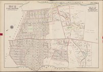
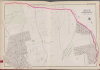
… [Map bounded by
Town
of Mamaroneck,
Union
Ave
… of the
town
of York
Town
… of the
Towns
of York
Town
… Rd.,
Town
of White Plains,
Town
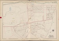
… [Map bounded by
Town
… [Map bounded by
Town
of Greenburg,
Town
of White
… [Map bounded by
Town
… of the
towns
of Somers
… County, York
Town
, Hudson
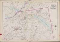
… of the
Towns
of Poundridge
… [Map bounded by
Town
… of the
Towns
of North Castle
….,
Union
Ave.]
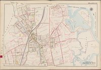
… of Harrison,
Town
of Scarsdale
…, Hudson River, Tarry
town
]
… River, York
Town
, New
… Sprain Rd.,
Town
… of Connecticut,
Town
of harrison
… by Cortlandt York
Town
, Village
… [Map bounded by
Town
… [Map bounded by
Town
… [Map bounded by
Town
… Boston Post Rd.,
Town
… [Map bounded by
Town
…. Pleasant,
N
. Broadway
… and Co., 147
N
. Fifth St
… and Co., 147
N
. Fifth St
End of results
|
Top