Click to visit the main New York Public Library Homepage
The New York Public Library
Digital Collections
About Digital Collections
Browse
Search only public domain materials
Items
Collections
Divisions
Home
Search
Browse
About
Search only public domain materials
Items
Collections
Divisions
Digital Collections
Using Images
Using Data
Search
Filtered keyword search
Show filters
Hide filters
Show Only Public Domain
topic
x
City planning
Real property
6
Landowners
3
Buildings
1
Fires
1
More
Less
name
American Photo-Lithographic Company
1
Baist, G. Wm. (George William), 1859-1927
1
Covington & St. Tammany Land and Improvement Company
1
Davis, Thomas W. (Surveyor)
1
Ewen, Edward S
1
More
Less
collection
Maps of North America
4
Maps of New York City and State
2
place
Boston
2
Manhattan (New York, N.Y.)
2
Massachusetts
2
New York (N.Y.)
2
New York (State)
2
More
Less
genre
x
Cadastral maps
Maps
6
publisher
publisher not identified
2
Am. Photo-Lithographic Co
1
Covington & St. Tammany Land and Improvement Co
1
G. Wm. Baist, Map Publisher
1
division
Map Division
6
type
cartographic
6
Date Range
to
6 results found for:
x
maps
Filtering on:
x
Genre
: Cadastral maps
x
Topic
: City planning
Sort by:
Relevance
Title
Date created
Date digitized
Sequence
Map
of the Melrose addition to Roanoke City
note:
Prepared by G. Wm. Baist,
Map
Publisher.
Map
of land to be acquired under Chapter 191
Plan of Public Garden: showin…
note:
Mapping
the Nation (NEH grant, 2015-2018)…
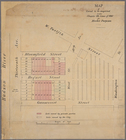
Map
of New Covington, in St. Tammany
note:
Mapping
the Nation (NEH grant, 2015-2018)…
Plan of burnt district (by fi…
note:
Mapping
the Nation (NEH grant, 2015-2018)…
m
Map
of the City of New York north
collection:
Map
of the City of New York north of 155